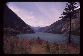
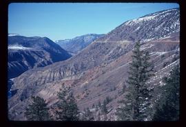
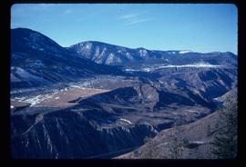
Mostrando 70 resultados

Archival description
65 resultados con objetos digitales Muestra los resultados con objetos digitales
Lillooet - Howe Sound
2012.13.1.054 · Sub-séries · [between 1977 and 1987]
Parte de J. Kent Sedgwick fonds

File contains slides depicting places around and between Lillooet and Howe Sound.

River Ferry
2012.13.1.66.01 · Item · June 1987
Parte de J. Kent Sedgwick fonds

Image depicts a ferry on a river, possibly the Fraser River in the Lillooet area.

River Ferry
2012.13.1.66.02 · Item · June 1987
Parte de J. Kent Sedgwick fonds

Image depicts a ferry on a river, possibly the Fraser River in the Lillooet area.

Lillooet Area
2012.13.1.053 · Sub-séries · [between 1971 and 1982]
Parte de J. Kent Sedgwick fonds

File contains slides depicting places in the Lillooet area.

Moran Canyon
2012.13.1.53.23 · Item · Mar. 1975
Parte de J. Kent Sedgwick fonds

Image depicts the Fraser River running through the Moran Canyon near Lillooet, B.C.

Moran Canyon
2012.13.1.53.19 · Item · Mar. 1975
Parte de J. Kent Sedgwick fonds

Image depicts the Fraser River running through the Moran Canyon near Lillooet, B.C.

Moran Canyon
2012.13.1.53.24 · Item · Mar. 1975
Parte de J. Kent Sedgwick fonds

Image depicts the Fraser River running through the Moran Canyon near Lillooet, B.C.

Moran Canyon
2012.13.1.53.21 · Item · Mar. 1975
Parte de J. Kent Sedgwick fonds

Image depicts the Fraser River running through the Moran Canyon near Lillooet, B.C.

Moran Canyon
2012.13.1.53.20 · Item · Mar. 1975
Parte de J. Kent Sedgwick fonds

Image depicts the Fraser River running through the Moran Canyon near Lillooet, B.C.

Moran Canyon
2012.13.1.53.22 · Item · Mar. 1975
Parte de J. Kent Sedgwick fonds

Image depicts the Fraser River running through the Moran Canyon near Lillooet, B.C.

Moran Canyon?
2012.13.1.53.27 · Item · Mar. 1975
Parte de J. Kent Sedgwick fonds

Image depicts what is possibly the Fraser River running through the Moran Canyon near Lillooet, B.C.

2020.08 · Colección · [between 1905 and 1926]

This collection consists of photographs and "real photo" postcards that depict the construction and operation of the Pacific Great Eastern Railway line, communities nearby the railway line, and regional geography of areas adjacent to the PGE line.