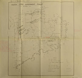
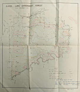
Item is a photocopied 1944 map depicting Fort George, published by the British Columbia Department of Lands.
Original forest cover map shows timber history in the area of Giscome, BC.
Item is a photocopied 1949 pre-emptor's map of Fort George, published by the British Columbia Department of Lands.
Original linen map depicts mining claims in the Cassiar District of British Columbia that were located in 1900-1901: L. 115 Princess Louise, L. 310 North Star, L. 311 Bonanza, L. 309 Emerald, and L. 312 Emma.
Item is an original 1950 pre-emptor's map of the Chilcotin region, published by the British Columbia Department of Lands and Forests.
Item is a photocopied plan depicting the Eagle Lake Sawmills Ltd. in Giscome, British Columbia with the plan of the sawmill and adjacent buildings, published by Transit Survey by L.C. Gunn and P.J. Klotz.
Map is a mylar reproduction of an Aleza Lake Forest Reserve map.
Item is an original 1952 map depicting Isle Pierre in British Columbia, published by the British Columbia Department of Lands and Forests. Map includes pen markings.
Map depicts the CNR system in Canada and the United States and all of its connecting lines, including the Central Vermont Railway, the Grand Trunk Western Railroad, and the Duluth Winnipeg & Pacific Railway.
Item is an original 1952 map depicting Isle Pierre British Columbia, published by the British Columbia Department of Lands and Forests.
Map reflects reserve boundary, roads, trails, 20 feet contour intervals, air photo centre, declination, swamps, and mile post at the Aleza Lake Forest Reserve.
Item is an original 1954 map depicting Salmon Valley British Columbia, published by British Columbia Department of Lands and Forests. Map includes pen markings.
Map is an uncontrolled mosaic of aerial photography of the Aleza Lake Research Forest, with a July 1955 date of the air photography. Duplicate exists.
Map depicts the Cowichan Lake area, including rail trackage for the Western Forest Industries Logging Railway, the Canadian National Railway, and the BC Forest Products Logging Railway.
Item is an original 1955 map depicting surficial geology of Anahim Lake, British Columbia published by the Geological Survey of Canada.
Map depicts the growth of Vancouver's street car system as from the laying of the first tracks in 1889 to the last section laid (Clark Dr., Hastings to Venables).
The map depicts the biotic regions and forests in British Columbia.
Map depicts the climactic regions of British Columbia which includes the coast, interior, and the northwest.
Map of Timber Sale X72108 shows area to be scarified, as well as previously logged areas. Location is outside Prince George in the Upper Fraser area near Kenneth Creek.
Map of Timber Sale X72108 shows area to be scarified. Location is outside Prince George in the Upper Fraser area near Kenneth Creek.
Logging plan of Sinclair Spruce Lumber Company's T.S.X. 73378 at Hubble Creek shows areas to be cut.
Logging plan of Sinclair Spruce Lumber Company's T.S.X. 73378 at Hubble Creek shows areas to be cut. Annotations show areas logged.
Map is a photocopy reproduction of the Aleza Lake Experiment Forest working circle timber sale map that was included in the appendix to the 1957 Aleza working plan.
Map is a photocopy reproduction of the Aleza Lake Experiment Forest development map that was included in the appendix to the 1957 Aleza working plan.
Map is a photocopy reproduction of the Aleza Lake Experiment Forest permanent plot map that was included in the appendix to the 1957 Aleza working plan.
Map is a photocopy reproduction of the Aleza Lake Experiment Forest map that was included in the appendix to the 1957 Aleza working plan.
Map depicts the City of Squamish, Howe Sound, and the Britannia Mine.
Item is a map of British Columbia and is a key map showing: maps published on scale 1 inch to 2 miles and summary zones of the provincial forest inventory. Map includes index of post offices correct to October 22, 1956.
Map is a photocopy reproduction of the "Aleza Lake Experiment Forest" map that was included in the appendix to the 1957 Aleza working plan.
File contains handwritten cross section book, original studies with handwritten measurement charts and black and white photos, loose pages of original correspondence, handwritten diagrams and measurement charts, loose handwritten tally sheets, black and white photographs, hand coloured plot diagrams, photocopies of aerial photographs, and original correspondence for Plot 160.
Item is an original 1961 map depicting Giscome in British Columbia, published by the Army Service Establishment, R.C.E. Map includes pen markings.
Item is an original 1961 map depicting Prince George .
Item is a photocopied 1961 National Topographic System map of Sinclair Mills in British Columbia, published by the Canadian Department of Geography. The map includes pen markings.
Map depicts the Abbotsford area, including railway lines.
Item is an original 1961 partial map depicting Giscome, published by the Army Service Establishment, R.C.E. Map includes pen markings.
Item is a map of British Columbia's Status of Sustained-Yield Forestry Programme as at 31 December 1962. The map has been annotated to show forest area surveyed by Celgar Ltd. as base for new kraft mill.
Map reflects reserve boundary, roads, trails, 20 feet contour intervals, air photo centre, declination, swamps, and mile post at the Aleza Lake Forest Reserve.
Map reflects reserve boundary, roads, trails, 20 feet contour intervals, air photo centre, declination, swamps, and mile post at the Aleza Lake Experiment Forest.
File consists of:
- "Development Study - Northern Resources" by the Columbia Cellulose Company, Limited, September, 1963. This report includes: background information on the company and a contextual background of forestry in British Columbia; a description of resources and proposed facilities, which covers northern wood resources and requirements for future sulphite and sulphate mills; an economic study for new Kraft operations.
- 2 maps: one of British Columbia entitled "Status of Sustained-Yield Forestry Programme as at 31 December 1962" by the Department of Lands, Forests, and Water Resources; the other of British Columbia Forest Service Forest: Surveys and Inventory Division, Key Map Showing: Maps published on scale 1 inch to 2 miles and summary zones of the provincial forest inventory by the Department of Lands and Forests (1957).
Map is an original linen Aleza Lake Experiment Forest map that reflects the reserve boundary, roads, trails, 20 feet contour intervals, air photo centre, declination, swamps, and mile posts.
Map reflects lot and STL lines, timber sale boundaries, Highway 16, roads, beetle infested areas, and plots X91971 to X91980, and X89946.