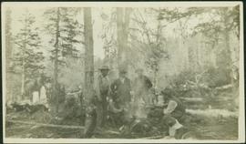
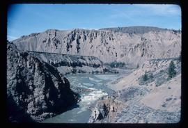
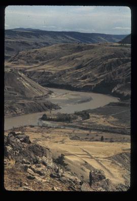
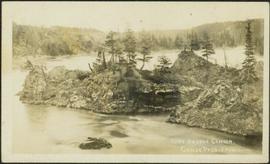
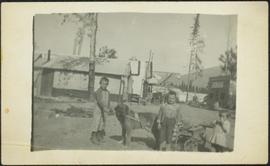
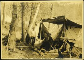
Photograph depicts three men and dog in tent campsite. Cooking supplies and miscellaneous items in throughout, forest trees in background. Handwritten annotation on verso and recto of this photograph reads: "Camp on Upper end of Grand Canyon".
Photograph depicts six men around fireside in forest, trees felled on either side. Bob Potts sits on far right, next to dog in foreground. These men are believed to be members of A. K. Bourchier's crew on the Upper Fraser River. Handwritten annotation on recto of photograph: "Preparing The miday meal. frying Bacon on sticks. Potts. Chief Chef."
Photograph depicts Mrs. Houghtaling standing with four small children near doorway of tent building (Gertrude, Mary, Henry, and Charlie). This photograph is believed to have been taken at Sand Creek, BC. Forest trees in background. Handwritten annotation on recto of photograph reads: "Tete Jaune 1912".
Postcard photograph depicts lofty view of sternwheeler in river, snow capped mountains in background.
Printed annotation on recto reads: “R.M.S. B.C. Express in Upper Canyon Fraser River.”
Image depicts the Fraser River in the upper Fraser Canyon.
Image depicts a view of the Upper Fraser Canyon. The Fraser River is visible.
Image depicts the Fraser River running through the Upper Fraser Canyon.
Image depicts the Fraser River somewhere in the Lillooet area.
Image depicts the Fraser River near Lillooet, B.C.
Image depicts the Fraser River running through the Moran Canyon near Lillooet, B.C.
Image depicts the Fraser River near Lillooet, B.C.
Image depicts two bridges over the Fraser River, located somewhere in Lillooet, B.C.
Image depicts an aerial view of a plateau near the Fraser River.
Image depicts an aerial view of the land near the Fraser River.
Image depicts an aerial view of the Fraser River.
Image depicts an aerial view of a stretch of road near the Fraser Bridge.
Image depicts the Fraser River, south of Soda Creek, B.C.
Image depicts the Fraser River, looking south from Marguerite, B.C.
Image depicts a farm on the west side of the Fraser, south of Quesnel, B.C.
Aerial view of Prince George featuring roadways and the confluence of the Fraser and Nechako rivers.
Annotation on verso: “Prince George from air 1936”.
Photograph depicts small log buildings and loaded wagons in cleared dirt area. Building on far left has the sign "POOL HALL" posted on front . Treetops, lumber piles, and hills in background. Mountains can be seen in distance. Handwritten annotation on verso of photograph reads: "Sand Creek. B.C."
Image depicts the Fraser River and a mountain in Longworth, B.C.
Image depicts an aerial view of grooves in the land near the Fraser River, possibly caused by glaciers.
Image depicts a view of grooves in the land near the Fraser River, possibly caused by glaciers.
Image depicts a view of a mountainous landscape, possibly near the Fraser River.
Image depicts what is possibly a section of the Fraser River.
Image depicts what is possibly the Fraser River.
Image depicts the Fraser River in the upper Fraser Canyon.
Image depicts the Fraser River, and a sign pointing towards Gang Ranch, in the Upper Fraser Canyon.
Image depicts the Fraser River, and a sign pointing towards Gang Ranch with an unknown individual hugging it, in the Upper Fraser Canyon.
Image depicts the Fraser River from the Moran railway point in the Lillooet area.
Image depicts a rail road bridge over the Fraser River, possibly somewhere in the Lillooet area.
Image depicts the Fraser River running through the Moran Canyon near Lillooet, B.C.
Image depicts the Fraser River near Lillooet, B.C.
Image depicts two bridges over the Fraser River, located somewhere in Lillooet, B.C.
Photograph depicts a small pass through an island or peninsula on the Fraser River. Photo is believed to have been taken near Stone Creek, south of South Fort George. Annotation on verso of photograph reads: "FORT GEORGE CANYON. CANOE PASS. J. HEAY. PHOTO."
Photograph depicts three small children (Henry, Charlie and Mary) standing at Sand Creek settlement. A dog stands beside them pulling a small wagon of firewood. Tent and wood buildings in background, including a cafe on far right. Hillside can be seen in distance. Handwritten annotation on recto of photograph reads: "Houghtaling Sand Creek Bourchier 1912".
Image depicts the Fraser River passing through the upper Fraser Canyon.
Image depicts the Fraser River near Gang Ranch in the Upper Fraser Canyon.
Image depicts a bridge over the Fraser River in the Upper Fraser Canyon; possibly near Gang Ranch.
Image depicts the Fraser River in the Lillooet, B.C.
Image depicts a view of the Fraser River near Lillooet, B.C.
Image depicts a view of the Fraser River and the mountains surrounding Lillooet, B.C.
Image depicts the Fraser River near Lillooet, B.C.
Image depicts the Fraser River running through the Moran Canyon near Lillooet, B.C.
Image depicts an area around Lillooet, B.C. It is possibly the Fraser River running through the Moran Canyon.
Image depicts a view of the Fraser River, as well as a road and railroad, near the Moran Canyon.