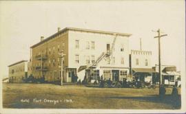
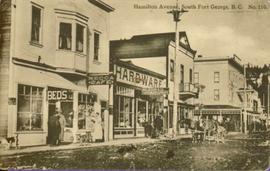
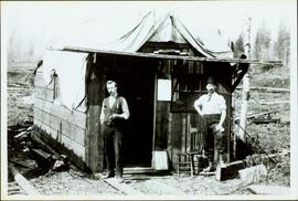
Imprimir vista previa Cerrar

Mostrando 74 resultados

Archival description
52 resultados con objetos digitales Muestra los resultados con objetos digitales
Third Avenue
2012.13.1.3.161 · Item · May 2001
Parte de J. Kent Sedgwick fonds

Image depicts 3rd Ave in Prince George, B.C. Map coordinates 53°55'01.9"N 122°44'48.7"W

Spruce dollars
2014.6.1.01 · Dossiê · 1958-1981
Parte de Rustad & Dezell Family fonds

File consists of various "Spruce Dollars" consisting of thin rounds of spruce wood stamped commemorating an event or place. Some are contained in their original plastic bags with some of the bags marked with the names of the people who owned them. File also includes a thank you note from UNBC for the donation.

Small wood investigation 1
2000.13.1.31 · Item · 1961.
Parte de Ray Williston fonds

Item is a photograph of Mr. Williston, Chief Forester John Stokes and Tom Wright of Canadian Forest Products examining an area near Prince George in order to determine the timber area required for a Pulp Harvesting License for a proposed pulp mill that would depend completely on waste wood.

2000.13.1.35 · Item · 1966.
Parte de Ray Williston fonds

Item is a photograph of, from left: John G. Prentice of Canadian Forest Products; Peter Bentley of CanFor; Mr. Williston; unknown; Premier W.A.C. Bennett; an unknown representative of Reed Paper and L.L.G. “Poldi” Bentley of Can For.

Prince George Postcard
2006.20.11.1 · Item · ca. 1940
Parte de Northern BC Archives Historical Photograph Collection

Postcard image depicts streetview looking west along 3rd Ave in Prince George, B.C. Storefronts and period automobiles are visible. Handwritten annotation on photographic negative, now visible along bottom of print image reads: "3rd Ave, Prince George B.C. Looking West. HND 41".

2010.13 · Colección · 1910 - [ca. 1950]

Collection contains photographs depicting community life in Prince George, B.C. Images depict holiday events, sports teams, government buildings, businesses (hotels, banks, retail, newspaper office), riverboats, railroad construction, fishing, a cemetery, street scenes, aerials, and landscapes. Also includes photos taken outside of the Prince George vicinity including Prairie Creek, Thomas Creek and Barkerville, B.C.

Prince George
2012.13.1.3.042 · Item · Nov. 1977
Parte de J. Kent Sedgwick fonds

Image depicts downtown Prince George looking northwest across Dominion Street. Map coordinates 53°54'48.7"N 122°44'45.6"W

Pine Centre Mall
2012.13.1.3.111 · Item · 12 Oct. 1989
Parte de J. Kent Sedgwick fonds

Image depicts Pine Centre Mall in Prince George, B. C. Map coordinates 53°53'53.2"N 122°46'36.4"W

Harkins History
2006.9.2 · Dossiê · 1998 - 2000
Parte de Bob Harkins fonds

Consists of 1 DVD entitled "Harkins' History" consisting of clips from Bob Harkins TV interviews with various personalities in Prince George covering a range of topics related to local and regional history. DVD includes two sets of clips of segments broadcasted from October 1999 to June 2000.

Sin título
Hamilton Avenue, South Fort George, BC
2011.3.2.10 · Item · [ca. 1910]
Parte de North Coast & Central BC Postcard Collection

Street scene showing people, dog, team of horses & wagon. Signage reads: “Beds; Mecca Café; Hardware.” Printed annotation on recto reads: “Hamilton Avenue, South Fort George, B. C. No. 110.” Verso displays cancelled 1 cent Canadian Postage Stamp and handwritten message in ink is addressed to Mr. Eathan Villard Burt Mish, U.S.A.

Green Gold-
2002.12.12 · Item · 1985
Parte de Bob Harkins fonds

Item consists of transcript of documentary consisting of forum with prominent members of the forest industry discussing the history of forestry in North Central British Columbia c.1960s-c.1980s. Participants include Bill Young, Keith Yorston, Ken Bernsohn, Hector Richmond, Russ Cousins, Harry Gairns, Don Gould, Orville Gorley, Frank Oberle, Includes 'logger's commandments' song.

Sin título
Government Buildings, Fort George, BC
2011.3.2.06 · Item · [ca. 1910]
Parte de North Coast & Central BC Postcard Collection

Photo of buildings behind street, fenced on either side. Man and horse can be seen on street. Printed annotation on verso reads: “The Government buildings Fort George B. C.” Handwritten annotation on recto reads: “This is the place I receive my patent from next June.”

Family Records series
2014.6.1 · Séries · 1953-2017
Parte de Rustad & Dezell Family fonds

Series consists of records reflecting the activities of the Dezell and Rustad families. Series include mayoral records from Bea and Garvin Dezell when Garvin served as Mayor of Prince George. Series includes materials celebrating Bea Dezell's life created by her family. Series also includes fundraising efforts for the Northern Medical Programs Trust. Finally, series includes a collection of "spruce" dollars and commemorative coins.

2012.13.1.3.110 · Item · 12 Oct. 1989
Parte de J. Kent Sedgwick fonds

Image depicts George St in downtown Prince George with City Hall in the background. Also visible are the Prince George Hotel, Ming's Inn Chinese Restaurant, Fraser Stationers Ltd., Weiner King food cart, and a movie theatre. Map coordinates 53°54'55.0"N 122°44'36.1"W

Downtown Prince George Businesses
2012.13.1.3.107 · Item · 12 Oct. 1989
Parte de J. Kent Sedgwick fonds

Image depicts 4th Ave at Brunswick St. and the following businesses: Hart Drugs, The Yarn Barn, and Saveco. Map coordinates 53°54'59.9"N 122°44'52.9"W

Downtown Prince George Businesses
2012.13.1.3.108 · Item · 12 Oct. 1989
Parte de J. Kent Sedgwick fonds

Image depicts 4th Ave at Quebec St, showing the following businesses: The Yarn Barn, Golden Chalice Jewellers, Dandy Lines, Ultrasport, and Saveco. Map coordinates 53°54'58.6"N 122°44'47.5"W

Central Street West
2012.13.1.3.115 · Item · 12 Oct. 1989
Parte de J. Kent Sedgwick fonds

Image depicts Central Street West, parallel to Highway 97 in Prince George, B.C. looking north. Shown: Prince George Motors and other car dealerships, Burger King, Grama's Inn, and the Spruceland Shopping Mall sign. Map coordinates 53°54'42.1"N 122°46'53.1"W

Central Business District
2012.13.1.3.057 · Item · July 1979
Parte de J. Kent Sedgwick fonds

Image depicts the Central Business District of Prince George looking north from Connaught Hill. Map coordinates 53°54'41.4"N 122°44'58.5"W