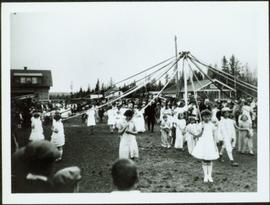
Imprimir vista previa Cerrar

Mostrando 950 resultados

Archival description
Yellowhead Bridge
2012.13.1.3.120 · Item · 12 Oct. 1989
Parte de J. Kent Sedgwick fonds

Image depicts the Yellowhead Bridge across the Fraser River. Map coordinates 53°54'45.2"N 122°43'27.9"W

Woodwards
2012.13.1.3.029 · Item · Oct. 1975
Parte de J. Kent Sedgwick fonds

Image depicts Parkwood Place taken from Connaught Hill looking west with the hospital in the background. Map coordinates 53°54'39.9"N 122°45'02.5"W

Wood Bridge and Snow Sculptures
2012.13.1.3.148 · Item · Apr. 1999
Parte de J. Kent Sedgwick fonds

Image depicts two snow sculptures near a wooden bridge on an ice rink, possibly during the Winter City Conference, in Prince George, B.C. Taken at the Prince George Civic Center. Map coordinates 53°54'45.6"N 122°44'59.6"W

Woman with a Paper
2012.13.1.133.10 · Item · 1985
Parte de J. Kent Sedgwick fonds

Image depicts a woman holding a sheet of paper in a room with numerous other unidentified individuals. The man standing behind her is possibly Elmer Mercier, a former Mayor of Prince George, B.C.

Woman in the Street
2012.13.1.128.06 · Item · 1994
Parte de J. Kent Sedgwick fonds

Image depicts a woman, wearing clothes reminiscent of traditional First Nations, who appears to be dancing in the street outside of a Native Friendship Centre in Prince George, B.C. A large crowd is looking on.

View of the CNR bridge
2002.1.29.2.006 · Item · 1950
Parte de Prince George Railway & Forestry Museum Collection

The CN Rail Bridge is a truss bridge over the Fraser River. It was built in 1914 by the Grand Trunk Pacific Railway and is therefore also known as the "GTP Bridge". The Canadian National (CN) Railway Company took over the Grand Trunk Pacific Railway in 1919.

View of the Agora, UNBC
2008.3.3.3.2 · Item · 26 May 1995
Parte de Bridget Moran fonds

Photograph depicts the Agora center at the University of Northern British Columbia in Prince George, B.C. Library building can be seen in right background, cafeteria building on far left. Unidentified individuals can be seen walking on campus. Accompanying note from Maureen Faulkner: "The processional gathers on the upper walkway". Photo believed to have been taken on the day Bridget Moran received an Honourary Law Degree.

View of the Agora, UNBC
2008.3.3.3.3 · Item · 26 May 1995
Parte de Bridget Moran fonds

Photograph depicts the Agora center at the University of Northern British Columbia in Prince George, B.C. Sign in foreground reads "Agora/Student Centre". Unidentified individuals can be seen in red blankets on upper walkway in background, above the Winter Garden. Accompanying note from Maureen Faulkner: "The first nations people, in button blankets, gather". Photo believed to have been taken on the day Bridget Moran received an Honourary Law Degree.

View of Prince George, BC from Above
2011.3.2.13 · Item · 1921
Parte de North Coast & Central BC Postcard Collection

Boardwalk in foreground, buildings and roads in mid ground, cut banks in background. Printed annotation on recto reads: “Prince George. B.C. 1921 by Moore”. Handwritten annotation in ink on verso reads: “The Netchaco river is between the mountain and the city and the C.N.R. runs along the river bank nearest the city. This picture is taken looking north.”

View of Prince George from east hill
2020.05.25 · Item · [Sept. or Oct. 1936]
Parte de Gordon Wyness Album

Photograph depicts a view of the city of Prince George looking west from the east hill. The confluence of the Fraser River and Nechako River is visible to the right. The Grand Trunk Pacific Railway bridge is visible at centre. The current location of where this photograph may have been taken is likely somewhere near where Highway 16 rises on the hill past the correctional centre (jail).

2008.3.3.3.1 · Item · 26 May 1995
Parte de Bridget Moran fonds

Photograph depicts road at University of Northern British Columbia. Library building stands in center background. Administration and cafeteria buildings can be seen in left background. Accompanying note from Maureen Faulkner: "Walking up to Canada's newest 'U' - ". Photo believed to have been taken on the day Bridget Moran received an Honourary Law Degree.

View of Fort George, B.C. from Above
2011.3.2.05 · Item · 1913
Parte de North Coast & Central BC Postcard Collection

Lofty view of South Fort George, river and treed hills in the background. Printed annotation on verso reads: “South Fort George - 1913.” Handwritten message on recto is addressed to “Ethel M. Heurris Norton Maps Bristol County" reads: "11-1-13 an excellent view of south Fort George taken recently. Power Station at cross near water. This does not give all the south residence view. Population approx 1500”.

View of Cenotaph from City Hall
2012.13.1.3.166 · Item · May 2001
Parte de J. Kent Sedgwick fonds

Image depicts a view of Prince George from City Hall looking northeast along George Street. Includes a back view of the Prince George cenotaph. Map coordinates 53°54'46.3"N 122°44'41.9"W

View from Gunn Point
2012.13.1.3.060 · Item · Nov. 1979
Parte de J. Kent Sedgwick fonds

Image depicts a view of Prince George from Gunn Point in the L.C. Gunn Park looking north. Map coordinates 53°54'26.2"N 122°43'35.8"W.

View from Gunn Point
2012.13.1.3.061 · Item · Nov. 1979
Parte de J. Kent Sedgwick fonds

Image depicts a view of Prince George from Gunn Point in the L.C. Gunn Park looking north. Map coordinates 53°54'26.2"N 122°43'35.8"W.

View from Gunn Point
2012.13.1.3.059 · Item · Nov. 1979
Parte de J. Kent Sedgwick fonds

Image depicts a view of Prince George from Gunn Point in the L.C. Gunn Park looking north. Map coordinates 53°54'26.2"N 122°43'35.8"W.

View from Gunn Point
2012.13.1.3.064 · Item · Nov. 1979
Parte de J. Kent Sedgwick fonds

Image depicts a view of Prince George from Gunn Point in the L.C. Gunn Park looking north. Map coordinates 53°54'26.2"N 122°43'35.8"W.