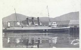
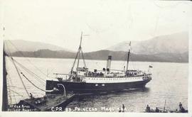
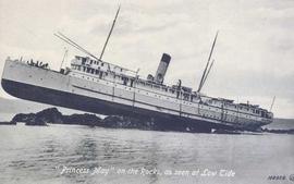
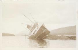
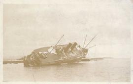
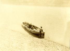
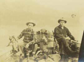
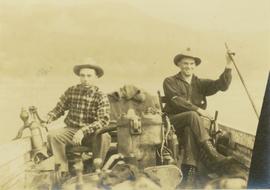
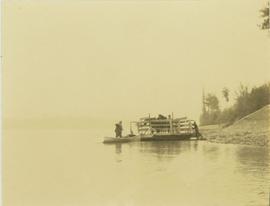
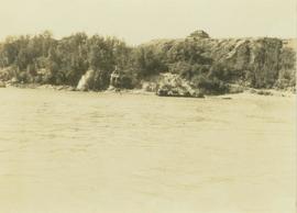
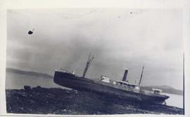
Photograph depicts an unidentified boat run aground on a rocky shoreline.
Photograph depicts the steamship Prince George docked on the water with buildings in the background. Annotation on recto of photograph states: "G.T.P. S.S. "Prince George"
Photograph depicts the steamship S.S. Princess Maquinna on the water with the stern of another ship in the foreground and a forested mountain range in the background. Annotation on recto of photograph states: "McRae Bros Prince Rupert C.P.R. S.S. PRINCESS MAQUINNA"
Photograph depicts the steamship Princess May run aground on rocks at low tide. Annotation on recto of photograph states: ""Princess May" on the Rocks, as seen at Low Tide"
Photograph depicts a ship beached on rocks, leaning heavily to one side with a forested shoreline in the background.
Photograph depicts a side view of a ship beached on rocks, leaning heavily to the side.
Photograph depicts the steamship Princess Kathleen on the water with tugboats in the foreground and a forested shoreline in the background. Annotation on recto of photograph states: "Princess Kathleen Photo by R.W."
Photograph depicts the steamship Camosun on the water with numerous passengers aboard. Annotation on verso of photograph states: "SS Camosun"
Photograph depicts the ship Princess Beatrice on the water with passengers aboard. Annotation on verso of photograph states: "Princess Beatrice"
Photograph annotation states that image depicts a CPR warehouse located about 1/4 mile east of the Revelstoke depot, on the north side of the track. The view is looking east. Additional information provided by railway historian Tom W. Parkin: This building is the CPR icehouse at Revelstoke after a partial tear-down. The structure was built after 1929, when a similar facility near the locomotive shops was removed between 1920-29, possibly to make room for a larger turntable. The location is on the northwest edge of the CPR yards. Icehouses once made and stored blocks of ice for refrigeration of passenger coaches and (when crushed) for cooling fresh produce in "reefer cars" en route to market.
Photograph depicts five men loading packed bags into a long boat belonging to Mac McGarvey. The boat is resting near the shore of an inlet at Rolla Landing.
Photograph depicts Prentiss Gray (left) and Mac McGarvey (right) seated in a boat on the Peace River.
Photograph depicts Mac McGarvey (left) and Frank Dewing (right) getting the boat "Starvation" ready on a rocky shoreline in preparation for travel on the Peace River.
Photograph depicts Mac McGarvey (right) and Frank Dewing (left) seated in a boat on the Peace River. Mac McGarvey is steering the boat while Frank Dewing is pumping water from the boat.
Photograph depicts Mac McGarvey (right) and Frank Dewing (left) sitting in a boat on the Peace River. Mac McGarvey is steering the boat while Frank Dewing is pumping water from the boat. In the background a low mountain range is visible.
Photograph depicts three men working to move a raft carrying two horses from Hudson's Hope ferry landing.
Photograph depicts three men and a child loading packs into a boat along the shoreline of an inlet at Rolla Landing.
Photograph depicts a view of the Hudson's Hope ferry seen from across the river. Behind the ferry, in the background is a rocky cliff face.
Plan depicts Granville Island industrial sites in False Creek, Vancouver. Shows revised trackage from 1955 annotated in colour by Davies.
Photograph depicts the CPR line at Revelstoke. The present terminus is about 1 mile south of the mainline depot of the former Arrowhead branch line (27.5 miles long) which became submerged when Arrow Lake was raised 70 ft. in 1968-1969.
Photograph depicts a 4-wheeled cart located on Tsalalh Nation territory at the head of Seton Lake.
Photograph depicts Beaver Trucking located on Kamloops Indian Reserve No. 1 on Tk'emlups te Secwepemc territory, Kamloops, BC. It had been a company since 1990 and received 2 or 3 boxcars weekly loaded with items from Toronto that were then delivered around town. Davies later noted that the business was destroyed by arson in 1997.
Three Indigenous men stand in a canoe poling their craft along a shoreline while one man sits and steers. An unidentified village is visible along the opposite shore.
Photograph of a long bridge spanning two rock faces. A small settlement is visible on the lower right.
File includes calendars depicting historical Prince George that were published by the Fort George Museum. Includes the following calendars published by the Fraser-Fort George Museum: "1985 Calendar" (1985); "The arrival of the steel" (1983); "Transportation" (Jan 1986-June 1987); and "Prince George: old & new" (1980).
File consists of a special edition of the Prince George Citizen newspaper titled "70 years of Rail!" (27 Jan. 1984).
File consists of a "BC Rail" special edition of the Prince George Citizen newspaper celebrating 75 years of railway (21 May 1987).
File consists of notes and reproductions relating to a brochure about the Fort George Railway and the "Little Prince" 24? gauge steam engine. Includes: "Fort George Railway" brochure prepared by Kent Sedgwick (May 1988); "Fort George Railway Society" typescript letter to George Finsterle from Kent Sedgwick (1 May 1989); and "Fraser-Fort George Regional Museum" brochure (1988).
File consists of notes, clippings, and reproductions relating to the arrival of the railway in Fort George. Includes material on railway development and building of the railway in Fort George.
File consists of notes, clippings, and reproductions relating to highway transportation in and around the Prince George area. Includes material regarding the Old Cariboo Highway; the Yellowhead Highway east; and Highway 97 north. Includes: "RE: Proposed Bridge at Isle Pierre" typescript letter from Kent Sedgwick to Ken Pedergast, District Manager (4 Oct. 1991) and "Year 2000 Calendar Bridges of BC" calendar for the year 2000 produced by Argentis (2000).
File consists of notes, clippings, and reproductions relating to sternwheelers. Includes material regarding Pacific Great Eastern sternwheelers on the Fraser River; the B.X. sternwheeler; Trelle Morrow's book "Sternwheelers on the Upper Fraser" published in 2009; and sternwheeler travel on the Fraser River. Includes: "The Pirates of South Fort George" clipped article from Today's Consumer magazine (April 1989).
File consists of notes and clippings relating to the Cariboo Road. The Cariboo Road (also called the Cariboo Wagon Road, the Great North Road or the Queen's Highway) was a project initiated in 1860 by the Governor of the Colony of British Columbia, James Douglas. The road stretched from Fort Yale to Barkerville, B.C. through hazardous canyon territory in the Interior of British Columbia.
File consists of notes and reproductions relating to Marcus Smith. Marcus Smith was a railway surveyor and in 1872 he was appointed as deputy to the Engineer-in-Chief of the Canadian Pacific Railway and took charge of British Columbia surveys between 1876-78. He worked as a surveyor for the CPR until 1886.
File consists of notes, clippings, and reproductions relating to the British Columbia Express Company. Barnard's Express, later known as the British Columbia Express Company or BX, was a pioneer transportation company that served the Cariboo and Fraser-Fort George regions in British Columbia, Canada from 1861 until 1921.
File consists of notes, clippings, and reproductions relating to ferry boat service in and around Prince George. Includes material regarding the Fraser River Fort George ferry; the Isle Pierre ferry; and the Miworth ferry. File also includes photographs depicting a building at Isle Pierre in the 1970s and the ferry crossing at Isle Pierre in 2005.
File consists of notes and reproductions relating to the land surveys conducted between 1871 and 1876 to find a route across British Columbia for the Canadian Pacific Railway. File contains material regarding surveyor Charles Horetzky; surveyor Sir Sandford Fleming; surveyor Joseph Hunter and the Pine Pass; and the proposed routes for the Canadian Pacific Railway in British Columbia.
File consists of notes and reproductions relating to a presentation on the Grand Trunk Pacific Railway conducted by Kent Sedgwick. Includes a CD titled "GTP Talk" containing a recording of Kent Sedgwick's presentation on the Grand Trunk Pacific (Oct. 2010).
File consists of notes, clippings, and reproductions relating to the Grand Trunk Pacific Railway survey and construction. Includes: "70 years of Rail!" special edition of the Prince George Citizen newspaper (27 Jan. 1984). Includes photographs depicting the Prince George roundhouse in its original location and various trains surrounding it.
File consists of notes, clippings, and reproductions relating to a failed tunnel build for the Grand Trunk Pacific Railway line between McBride and Goat River and a potential homestead on the land surrounding the tunnel. The land was later owned by Russ Purvis of Dunster in 2006.
File consists of notes and reproductions relating to the Canadian Northern Railway. File contains material regarding the CNR railway station at Boston Bar; the community and railway stop at Basque; development of the CNR; and the CNR in Lucerne, British Columbia.
File consists of notes and reproductions relating to the Grand Trunk Pacific Railway. File contains material regarding mileages, railway stations, and lists of the GTP railway line stations.
File consists of notes and reproductions relating to the Goat River railway station. Includes photographs depicting the Goat River station and a painting of the station (2009).
File consists of notes and reproductions relating to the Penny station. Also includes photographs depicting the Penny train station (1980?).
File consists notes and reproductions relating to the Dunster station and Mcbride station. Includes: "Re: Dunster Station - Grants, etc". typescript letter from Derek Trimmer, Heritage Advisory Committee, to Karen Craigue, Dunster Community Association (21 Apr. 1988) and "Proposal for the Acquisition, Restoration and use of the Dunster C.N.R. Station" typescript document prepared by Heritage Committee of Dunster Community Association (Feb. 1986). Also includes a photograph depicting the Dunster station (1980?).
File consists of notes and reproductions relating to townsites along the Grand Trunk Pacific Railway. Includes material regarding townsite planning for McBride, Willow River, Prince George, Terrace, Prince Rupert, and South Hazelton.
File consists of notes, clippings, and reproductions relating to the original Pacific Great Eastern Railway line. Also includes photographs depicting various dirt roads (2001-2010).
File consists of notes and reproductions relating to the Grand Trunk Pacific Railway in Prince Rupert. Also includes a map depicting the Prince Rupert townsite (before 1980).
File consists of notes, clippings, and reproductions relating to the Pacific Great Eastern Railway line. Includes: "Remembering" special edition of the Coupler Marking the 75th anniversary of BC Rail and the PGE Railway (Jan. 1987). Also includes a photograph depicting the Ahbau railway bridge (2005).
File consists of notes, clippings, and reproductions relating to railway heritage in British Columbia. Includes: "Heritage West" volume 8 number 3 of Heritage West magazine (1984); "Article to be Published" typescript document by Kent Sedgwick sent to Heritage West (1984); "geography 103 Endako - McBride" typescript document by Allan MacDonald (1980); "BC Rail" special edition of the Prince George Citizen newspaper (May 1987); and "Heritage Cranbrook" promotional booklet (2004).