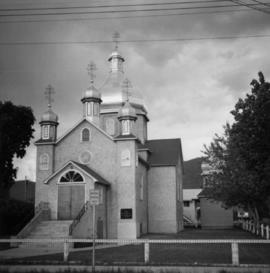
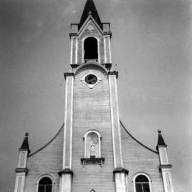
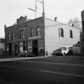
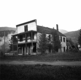
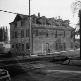
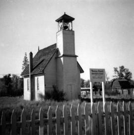
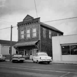
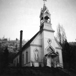
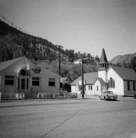
Photograph depicts a liquor store and church on Main St. in Lillooet, B.C.
Photograph depicts a log barn at Lookout Lodge beside Shuswap Lake, between Sorrento and Squilex.
Photograph depicts the United Church at Spences Bridge in the Fraser Canyon. The church is on the flats on the west side of the river and close to the C.N. depot.
Photograph depicts a shop on the north side of Main St. in Cumberland on Vancouver, Island.
Photograph depicts the brick works at Haney, B.C., within 100 yards of the Fraser River. Current production appeared to be bricks, tiles, and flowerpots. There is a disused railway spur in the works
Photograph depicts a Ukrainian Greek Orthodox Church on 27th St. and 41st Ave. in Vernon, B.C. in the Okanagan.
Photograph depicts a post office on Main St. in Cumberland on Vancouver Island. It was built in 1907 in a similar style to the building in Ladysmith.
Photograph depicts the junction of Robson and Cordero St. in west end Vancouver, B.C. The photo is looking northwest on the newly demolished block, except for some houses at far end. View is looking down Robson St., with Cordero St. intersecting the photo.
Photograph depicts a fisherman's house, lived in and owned by a First Nations man (?), on the south bank of the south arm of the Fraser River. It is about 5 miles southeast of New Westminster at approximately 9000 block of River Road.
Photograph depicts a house on Nicola St. at the southwest corner of the intersection of Nicola and Robson St., in Vancouver, B.C.
Photograph depicts Alberni St. in the west end of Vancouver. It is directly opposite the Vehicle Testing Station, in the 1700 block. The view in the photo is looking east.
Photograph depicts one of the few surviving old style garages in west end Vancouver on Barclay St.
Photograph depicts a disused schoolhouse with the dates "1925" and "1902" on it. It is on River Rd. on the south bank of the Fraser River in Delta, opposite the west end of Annacis Island.
Photograph depicts the Delta Municipal Hall on Main St. in Ladner, B.C.
Photograph depicts a Chinese farmer's buildings on the Port Guichon Rd. on the outskirts of Ladner, B.C.
Photograph depicts a settler's log cabin, about 1 mile from the main road of Sechelt Peninsula and on the side road leading to Gordon Bay, at a point where a small stream cease to be tidal. Vertical cracks in logs stuffed with rags and horizontal cracks filled with cement.
Photograph depicts the B.C. Forest Service Ranger's administration and equipment building at Pender Harbour in Sechelt, B.C.
Photograph depicts a house on Ladner Trunk Rd. in Delta, B.C. It is in the northeast corner of an intersection with the road leading to the Canadian Army Signal Station.
Photograph depicts a barn at Lund, a village 12 miles north of Powell River. This building overlooks the harbour.
Photograph depicts St. Hilda's Anglican Church in Sechelt on the Sechelt Peninsula. Tall tree on left just coming into flower is a dogwood.
Photograph depicts a Roman Catholic church, "Our Lady of Lourdes," on the First Nations reservation, Sechelt Village. It was built in 1907 and is now closed, but the heavy bell is still in position in the belfry.
Photograph depicts the church of His Presence in Halfmoon Bay, Sechelt. It was built in 1962 by Cannon Greene, a former seafaring minister of the Columbia Coast Missions and the subject of a C.B.C. T.V. production in early April 1966.
Photograph depicts St. Paul's Anglican Church in Powell River. The church was built in 1955.
Photograph depicts the seaward end of C.P.R. pier A1 (now 12A), showing its rotted condition. The pier was built in 1890 and is still in use except at this outer face. C.P.R. pier B1 is in the background.
Photograph depicts the C.P.R. pier A.1. (now 12A) at Vancouver, B.C., slightly right of the foot of Thurlow St. It was built in 1890 and it is still in use. The view shows its east face.
Photograph depicts a barn at Port Guichon, 1 mile west of Ladner, Delta.
Photograph depicts a former fire hall now used as a boy's club on 12th Ave and St. Catherine's St., in Vancouver, B.C. It is one and a quarter miles southeast of C.N.R. station.
Photograph depicts Pier B of C.P.R., just west of the C.P.R. railway station. This is the only pier accessible to ocean going passenger liners and is used by P&O vessels. Facilities generally in adequate for the 1960s.
Photograph depicts the Sun Building at the intersection of Beatty and West Pender St. in Vancouver, B.C. The photo was taken after the Pacific Press Ltd. Vacated the building on December 26, 1965, and the "Sun" neon sign on the tower was removed. The view is looking west from West Pender St.
Photograph depicts the Pacific Press Ltd. Vancouver Sun building at Beatty and West Pender St. The view is looking northeast from Beatty St. It was vacated by the Vancouver Sun at Christmas 1965 with the neon "Sun" sign on the tower removed.
Photograph depicts the Buckingham Apartments at 925 Cardero St. in Vancouver, B.C. after a snowfall. The view is looking south and depicts Barclay St. crossing in the foreground.
Photograph depicts one of the earlier brick buildings beside the river, sited opposite the sternwheeler landing pier. It is called Commercial Block and was built in 1897.
Photograph depicts the Upper Clearwater Hall on a dirt road between Clearwater (70 miles north of Kamloops) and the entrance to Wells Gray Provincial Park. The cracks between the logs recently re-cemented.
Photograph depicts a derelict shop on what was the Main St. of Slocan City.
Photograph depicts an abandoned log cabin in the Kettle Valley between Rock Creek and Westbridge, on the east side of the road approximately 5 miles from Rock Creek.
Photograph depicts the city hall in Rossland, B.C. built in 1990, during its heyday.
Photograph depicts a possibly derelict hotel in Slocan City, 25 miles northwest of Nelson. Slocan City was once famous for its silver, lead etc. mines.
Photograph depicts a courthouse at Revelstoke, B.C. that was built in 1912-1913.
Photograph depicts a cattle shelter/ barn at the head of Nicola Lake, 20 miles east of Merritt, near the Douglas Lake road turnoff.
Photograph depicts stores in Kaslo on Kootenay Lake, 40 miles northeast of Nelson. This town still has 15 miles of dirt road leading to it.
Photograph depicts a church on Wood St. in Greenwood, which is between Oliver and Grand Forks. The church may have been Roman Catholic.
Photograph depicts the derelict Langham Hotel at Kaslo, B.C. on Kootenay Lake.
Photograph depicts the fire hall in Moyie, 20 miles south of Cranbrook. When the photo was taken there were 2 hose reel carts inside, a hose, and huge log stove under the hose drying tower (partially seen through window). Moyie was a prosperous village about 1900-1910.
Photograph depicts the Windsor Hotel at Fort Steele, 10 miles northeast of Cranbrook. It was built in 1895 by Robert D. Mather and originally was called Dalgarno House. It is being renovated as a village museum.
Photograph depicts a derelict building on the old Main St in Slocan City, northwest of Nelson.
Photograph depicts a church built in 1876 in Nicola, 7 miles northeast of Merritt. It was originally a Presbyterian church and is one of the oldest in the interior, though it is now infrequently used.
Photograph depicts East Pender St., looking west towards the Vancouver Sun newspaper office near Abbot St. in Vancouver, B.C.
Photograph depicts a barn at Darfield, near Barriere, about 35 miles north of Kamloops. The English timbered cottage developed from this architectural form.
Photograph depicts the house opposite an 1876 church in Nicola village, 7 miles northeast of Merritt. It may be the manse.
Photograph depicts the Silver Ledge Hotel, Ainsworth Hot Springs, on the west side of Kootenay Lake, north of Nelson.