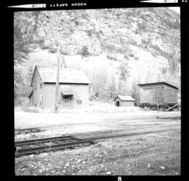
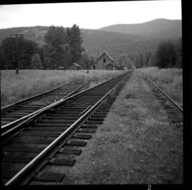
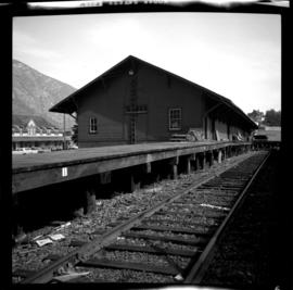
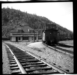
Print preview Close

Showing 4439 results

Archival description
3218 results with digital objects Show results with digital objects
CPR line at Boundary Falls
2013.6.36.1.028.02 · Item · 14 Sept. 1970
Part of David Davies Railway Collection

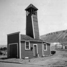
Photograph depicts the CPR line at Boundary Falls, which is at mile 121 from Nelson on the Boundary Subdivision. The view is looking west and it shows the former flag stop shelter.

CPR line at Greenwood
2013.6.36.1.028.03 · Item · 17 Sept. 1970
Part of David Davies Railway Collection

Photograph depicts the CPR line at Greenwood. There is no representative of the CPR in Greenwood now and the agency expired in June 1969. There appears to be 2 to 3 way freights per week from Nelson to Midway. The view is looking north and shows the depot house.

Grand Forks CPR depot
2013.6.36.1.028.04 · Item · Aug. 1983
Part of David Davies Railway Collection

Photograph depicts the Grand Forks CPR depot, located at mile 94.8 on the Boundary Subdivision, which runs from Nelson to Midway (127 miles). It was originally built by the Columbia & Western Railway in 1899. IT has not seen a passenger train in years but it is still in use for administrative purposes.

Grain elevator at Wynndel
2013.6.36.1.028.05 · Item · Aug. 1983
Part of David Davies Railway Collection

Photograph depicts the a grain elevator at Wynndel, located at mile 73.8 on the CPR line on the Nelson Subdivision. It is between Creston at mile 67.2 and Kootenay Landing at mile 83.1. Grain elevators are rare in BC and this one belongs to the United Grain Growers. The view is looking east.

Fernie CPR station
2013.6.36.1.028.06 · Item · Aug. 1983
Part of David Davies Railway Collection

Photograph depicts the Fernie CPR station, located at mile 34.7 on the Cranbrook Subdivision, which runs from Crowsnest to Cranbrook. In coal mining days this was a busy place but now it has sidings for 153 cars and nothing else. The view is looking east.

Nelson CPR Station
2013.6.36.1.028.07 · Item · 13 Aug. 1983
Part of David Davies Railway Collection

Photograph depicts the Nelson CPR depot, built in 1899. Since there are no passenger trains, freights used the front line, adjacent to the depot. The photograph was taken from the platform and shows a view looking east.

Nelson CPR Station
2013.6.36.1.028.08 · Item · Aug. 1983
Part of David Davies Railway Collection

Photograph depicts the Nelson CPR depot, built in 1899 and still well-maintained. Streetcars had a terminal in this yard from 1899-1949, for what was probable the shortest street car system in Canada. The view is looking north and shows the rear view.

2013.6.36.1.028.09 · Item · Aug. 1983
Part of David Davies Railway Collection

Photograph depicts two grain elevators at Creston, BC. The Creston CPR yard lies behind the camera. The line is on a downgrade away from the camera, starting its descent to the valley bottom for Kootenay Lake. The grain elevators are a rare sight in BC.

2013.6.36.1.028.11 · Item · 17 Sept. 1970
Part of David Davies Railway Collection

Photograph depicts the CPR line at Eholt, located at mile 108.7 from Nelson on the Boundary Subdivision. It was a formerly bustling junction with the left-hand spur leading to Phoenix. Nor it only has 3 way freight trains a week from Nelson to Midway. The view is looking west.

2013.6.36.1.028.26 · Item · 18 Sept. 1970
Part of David Davies Railway Collection

Photograph depicts a former icehouse at the Nelson CPR depot. It is located about 150 yards west of the main depot building. It also shows service boxcar CPR #412120, on the right track. The view is looking east.

2013.6.36.1.028.28 · Item · 18 Sept. 1970
Part of David Davies Railway Collection

Photograph depicts a freight shed at the Nelson CPR depot. There is a terminal spur on the south side of the shed and road trucks on the north side. The road side of the main depot building can be seen in the left rear of the photo. The view is facing east.

2013.6.36.1.028.31 · Item · Aug. 1983
Part of David Davies Railway Collection

Photograph depicts the Creston Sawmills Ltd on the CPR line. Here the southern BC CPR mainline passes through the center of trackage, looking eastbound. A chip car is on the spur directly leading from the camera.

CPR line at McConnell, BC
2013.6.36.1.028.35 · Item · Aug. 1983
Part of David Davies Railway Collection

Photograph depicts the CPR line at McConnell, BC, which is located at mile 55 on the Nelson Subdivision and 12 miles east of Creston. The view includes the signalman's shanty, which is still in occasional use.

CPR depot at Castlegar
2013.6.36.1.028.40 · Item · 14 Sept. 1970
Part of David Davies Railway Collection

Photograph depicts the CPR depot at Castlegar. The left-hand track leads to Trail and the right-hand track to Midway and Penticton. The picture was taken at about 1 pm with the Nelson to Midway way freight train standing at the depot. The caboose was built in 1913. The view is looking west.

Nelson CPR Depot
2013.6.36.1.028.41 · Item · 18 Sept. 1970
Part of David Davies Railway Collection

Photograph depicts the Nelson CPR depot . All the freight traffic work is handled at this office for a wide area. The view is looking west.

CPR depot at Proctor, BC
2013.6.36.1.028.43 · Item · 16 Sept. 1970
Part of David Davies Railway Collection

Photograph depicts the CPR depot at Proctor, located at mile 117.5 from Cranbrook on the Nelson Subdivision. David Davies notes: "The view is looking east and shows the spur at right leading to a barge slip on Kootenay Lake. The majority of the spur rails here are dated 1908-1910." An updated description provided by a subject expert suggests that this view is actually looking west.

Surviving building, Gerard
2013.6.36.1.072.02 · Item · 10 Sept. 1970
Part of David Davies Railway Collection

Photograph depicts the only surviving building in the ghost town of Gerard. Its survival was due to the ownership and periodic use of the B.C. Government Fisheries Department.

Abandoned house, Trout Lake
2013.6.36.1.072.03 · Item · 6 Sept. 1970
Part of David Davies Railway Collection

Photograph depicts an abandoned house in a semi-host town viallage that dated back to 1895-1900. It was coverd with hop flowers which was typical for most of the deserted homes in the area. Village had 20 buildings standings of which 12 were occupied.

2013.6.36.1.072.06 · Item · [July 1969]
Part of David Davies Railway Collection

Photograph depicts the Moha "ghost" vilage, 20 miles west of Lillooet, at the fork of Bridge and Yalako Rivers. It used to be a gold mining village. About 8 houses/cabins were left standing, but none were occupied. Displayed is one that had 2 ft. thick walss to waist height, as shown.

2013.6.36.1.072.19 · Item · 28 Oct, 1967
Part of David Davies Railway Collection

Photograph depicts a house that had a "sold" notice on it and was partly demolished. Up to the date the photograph was captured, this block on Beach Ave. was the sole remaining one to have only houses on it, as opposed to a mixture of houses and apartment blocks, or blocks only.

Kaslo City Hall
2013.6.36.1.073.03 · Item · 12 Sept. 1970
Part of David Davies Railway Collection

Photograph depicts the Kaslo City Hall, built in 1898. The first floor contained a library while the second floor held a coutroom with original furnishings in mild disarray.