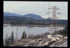
The item is a photograph slide reproduction depicting a flooded river and covered area in Fort George Park, currently Lheidli T'enneh Memorial Park.
The item is a photograph slide reproduction depicting the raised floodwaters on the Fraser River and the Cottonwood Trail.
The item is a photograph depicting a 1/48 scale model of the Cameron Street bridge. The angle is a side view of the bridge with a blue and a yellow model car on the bridge. Annotation on the reverse side of the photograph states, "Oct. 2008 1/48 scale model of the Cameron St. bridge 1931-2005 by Roy Groeneveld."
Image depicts the house of the owner of Gang Ranch.
Image depicts the Alkali Lake Ranch in Alkali Lake, B.C.
Image depicts a view of the Fraser River in Lillooet, B.C.
Image depicts some farmland in Lillooet, B.C.
Image depicts an old church located somewhere in Lillooet, B.C.
Image depicts a view of Lillooet, B.C.
Image depicts two bridges over the Fraser River, located somewhere in Lillooet, B.C.
Image depicts the start of Joffre Creek Road, most likely somewhere in the Joffre Lakes Provincial Park.
Image depicts the Britannia Mine, which closed in 1974 and is now a museum. "Anaconda" was the last operating owner.
Image depicts numerous power lines and a road somewhere north of Squamish.
Image depicts rail road tracks and several buildings in Pemberton, B.C.
Image depicts some power lines and mountains near Pemberton, B.C.
Image depicts what appears to be an apartment building among several others in an uncertain location.
Image depicts a lake with a "Swim at Own Risk" sign at an uncertain location.
Image depicts a building painted with First Nations art in New Aiyansh.
Image depicts several children and numerous adults inside a church in Deadman Creek, near Kamloops, B.C.
Image depicts the Ranch house on the historic Hat Creek Ranch site north of Ashcroft, B.C.
Image depicts an old barn on the historic Hat Creek Ranch site north of Ashcroft, B.C.
Image depicts the front of the ranch house on the historic Hat Creek Ranch site north of Ashcroft, B.C.
Image depicts the Lajoie Dam on the Bridge River from the upstream side.
Image depicts Bralorne, B.C.
Image depicts what is possibly an old, rundown mill in Bralorne, B.C.
Image depicts several houses in Bralorne, B.C.
Image depicts a few boarded-up buildings in Bralorne, B.C.
Image depicts an area of Barlone, B.C. surrounded by trees.
Image depicts a number of identical buildings and vehicles at "Driftwood Creek" in the Driftwood Canyon Provincial Park.
Image depicts a cabin on the "west arm" of Takla Lake.
Image depicts a few piles of culverts in Leo Creek, B.C.
Image depicts a building, possibly an office building, next to a set of rail road tracks in Leo Creek, B.C. An unknown individual is present, and a number of barrels and culverts are visible in the foreground.
Image depicts a sign titled "Chilcotin Wildlife Management Area" somewhere near Riske Creek, B.C. It reads: "This trail has been provided by the Fish and Wildlife Branch in co-operation with Riske Creek Ranching Ltd., as access to the Chilcotin Wildlife Management Area. Please do not leave the the trail as the surrounding land is private property."
Image depicts a ranch house in Meldrum Creek, B.C.
Image depicts two women at a table; the one on the right is possibly Sue Sedgwick. The image may have been taken in Meldrum Creek, B.C.
Image depicts the interior of an old, abandoned church at an uncertain location; possibly somewhere between Lillooet and Kamloops.
Image depicts three picnic tables, one of which is occupied with three unknown individuals, on a beach somewhere in Kitimat, B.C.
Image depicts the Alcan smelter in Kitimat, B.C.
Image depicts numerous docked boats in Kitimat, B.C.
Image depicts a view of the area surrounding Kitimat, with power-lines in the foreground the city partially visible in the distance.
Image depicts numerous houses in Kitwancool, B.C.
Image depicts an old Hudson Bay Company house in Kitwanga, B.C.
Image depicts an old Hudson Bay Company house, with a totem pole in the foreground, in Kitwanga, B.C.
Image depicts a south-west view of the Nass Valley.
Image depicts several individuals looking down into a closed off section of a river in Meziadin Lake Provincial Park. They are counting fish.
Image depicts numerous old and ruined cabins in Quesnelle Forks.
Image depicts a view of Quesnelle Forks and the nearby river.