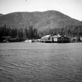
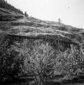
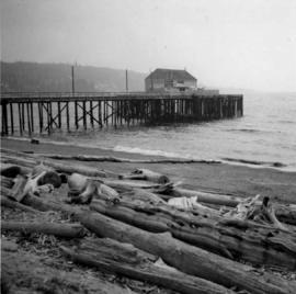
Photograph depicts block ships sunk to protect booming grounds at Powell River. The ships were former wartime naval vessels.
Photograph depicts the Hospital Cottage on Main St. in Sechelt, B.C. which also appears to have been home to the Magistrates and Small Debts Court at one point. A large central hospital for the whole of the Sechelt Peninsula was opened in 1965 at Sechelt.
Photograph depicts a view of downtown Vancouver taken from the east end of False Creek at the foot of Terminal Ave. The view is looking northwest. In the middle distance on the left is the pier of a railway bridge taking the Great Northern Railway line into the city. It was demolished in about 1915-1920 when a new Great Northern station was constructed.
Photograph depicts a fence at Nicola village, 7 miles northeast of Merritt.
Photograph depicts the Britannia Copper Mine in Howe Sound. The view is looking southeast.
Photograph depicts the general view of the waterfront buildings between Burrard and Thurlow St., in Vancouver Harbour looking northwest from Burrard St. The Immigration Building is on the left and the "Princess of Vancouver" (C.P.R.) is in the middle distance.
Photograph depicts a swimming pool at Second Beach in Stanley Park, Vancouver, B.C. The snow in the foreground is 16 inches deep and there is a gathering snowstorm in the background coming in from the west.
Photograph depicts the north shore of False Creek, looking west after a snowfall. Photo taken from the swing span of Cambie Bridge in Vancouver, B.C.
Photograph depicts Simon Fraser University in Burnaby, B.C. The view is looking east towards the nearly completed water tower from the west inner face of the Academic Quadrangle.
Photograph depicts Simon Fraser University in Burnaby, B.C. The view is looking northwest from the science complex towards the gymnasium.
Photograph depicts Simon Fraser University in Burnaby, B.C., one week after the official opening.
Photograph depicts Simon Fraser University in Burnaby, B.C. The view is looking northeast towards the northwest corner of the Academic Quadrangle.
Photograph depicts Simon Fraser University in Burnaby, B.C. The view is looking southwest from the mall towards the gym and sports arena.
Photograph depicts Simon Fraser University in Burnaby, B.C., 1 week after the official opening.
Photograph depicts a wooden irrigation flume on the west side of Oliver in the Osoyoos fruit valley, near #18 Rd.
Photograph depicts the sluice gates off the Nicola River, on a ranch at Nicola village, 7 miles northeast of Merritt.
Photograph depicts the west end of Coal Harbour looking south to West Georgia St. and Chilco-Gilford block beyond. The old pilings exposed at low tide.
Photograph depicts a general view of Coal Harbour in Vancouver, looking southeast and south with Marine Building (downtown) on extreme left and Stanley Park (unseen) at extreme right.
Photograph depicts a general view of Coal Harbour in Vancouver, looking southeast and taken from Royal Vancouver Yacht Club premises. Photo shows the Bayshore Hotel on the extreme left.
Photograph depicts the Vancouver Shipyards Ltd. on 555 Denman St. in Vancouver, B.C., looking south from Coal Harbour waters.
Photograph depicts a general view of the last 300 yards of the upper neck of Coal Harbour in Vancouver, B.C. The view is looking west and taken from the south side.
Photograph depicts a view looking northeast towards Coal Harbour from Alberni St. (Chilco-Gilford block) with West Georgia St. in the middle distance.
Photograph depicts a general view of the upper and south shore section of Coal Harbour in Vancouver, B.C.
Photograph depicts the upper end of Coal Harbour, on the south shore looking southwest and taken from the dock of the Vancouver Shipyards Ltd.
Photograph depicts the city hall at New Westminster on Victoria Day. The anvil battery firing round #3 of 21 gun salute.
Photograph depicts the city hall at New Westminster on Victoria Day. The anvil battery is about to fire a 21 gun salute.
Photograph depicts the inside of the suite at 925 Cadero St. in the west end of Vancouver, B.C.
Photograph depicts an empty site at 1000 Beach Ave. in Vancouver, B.C.
Photograph depicts home at #1053 Beach Ave., which is now fully demolished.
Photograph depicts the homes on 1000 Beach Ave. in Vancouver, B.C.
Photograph depicts the ongoing wrecking of house #1053 on Beach Ave.
Photograph depicts house at #1053 Beach Ave. in Vancouver, B.C. Dan Davies was a resident at one time.
Photograph depicts homes on 1000 Beach Ave. in Vancouver, B.C.
Photograph depicts the 1000 Beach Ave. block with dogwood rose tree in bloom at the left of the photo.
Photograph depicts homes on 1000 Beach Ave., looking northeast. House #1053 on the left has been demolished at this point and then set on fire one night by kids.
Photograph depicts homes on 1000 Beach Ave., looking northeast.
Photograph depicts a house fire possibly on 1000 Beach Block and Thurlow St. , caused by a wrecking gang.
Photograph depicts a house fire on 1000 Beach Block and Thurlow St. on December 18, 1964. A wrecking gang accidently set fire to the house and it took one hour to get the fire under control.
Photograph depicts a house fire possibly on 1000 Beach Block and Thurlow St. , caused by a wrecking gang.
Photograph depicts Tofino on Vancouver Island. View taken from wharf with a lifeboat on slip.
Photograph depicts the Pacific Terminus of the Trans Canada Highway in Tofino, B.C. on Vancouver Island.
Photograph depicts a deserted cannery at Nootka, on west Vancouver Island.
Photograph depicts a general view of Coal Harbour in Vancouver, taken from its head in Stanley Park, looking east. The Bayshore Inn is shown on the extreme left of the image.
Photograph depicts a dredge working on the shoreline of a new apartment site on the south side of Coal Harbour, Vancouver, B.C. Photograph taken from Stanley Park, looking east. The Bayshore Inn Hotel is shown in the rear center.
Photograph depicts the First Narrows looking east from the base of Point Atkinson lighthouse.
Photograph depicts a wharf at Lang Bay, 14 miles southeast of Powell River. In fair repair, now used only by an oil company to pump in oil to a storage depot behind the camera.
Photograph depicts a wharf at Sechelt village on the Sechelt Peninsula. The view is looking southeast towards Vancouver.