2020.4.7.013
·
Item
·
1982
Parte de G. Gary Runka fonds
3619 resultados com objetos digitais
Mostrar resultados com objetos digitais
2020.4.7.014
·
Item
·
1983
Parte de G. Gary Runka fonds
2020.4.7.015
·
Item
·
1982
Parte de G. Gary Runka fonds
2020.4.7.016
·
Item
·
1982
Parte de G. Gary Runka fonds
2020.4.7.017
·
Item
·
1982
Parte de G. Gary Runka fonds
2020.4.7.018
·
Item
·
[198-?]
Parte de G. Gary Runka fonds
Photocopied map depicts mineral and coal mining properties in north western British Columbia.
2020.4.7.019
·
Item
·
1982
Parte de G. Gary Runka fonds
2020.4.7.020
·
Item
·
1982
Parte de G. Gary Runka fonds
2020.4.7.021
·
Item
·
1988
Parte de G. Gary Runka fonds
2020.4.7.022
·
Item
·
Dec. 2005
Parte de G. Gary Runka fonds
2020.4.7.023
·
Item
·
1982
Parte de G. Gary Runka fonds
2020.4.7.025
·
Item
·
[2007]
Parte de G. Gary Runka fonds
2020.4.7.027
·
Item
·
19 Feb. 2008
Parte de G. Gary Runka fonds
2020.4.7
·
Série
·
1965-2009
Parte de G. Gary Runka fonds
Series consists of maps, technical drawings, and other oversize material collected by Gary Runka that are not associated with specific Land Sense Ltd. client jobs.

2014.10.1.054
·
Item
·
1909
Parte de Arthur Holland Land Surveying Collection
Photograph depicts a cluster of wooden buildings including a flagpole and church spire at a Lheidli T'enneh village site. Original photo identified this image as "Indian Village, Fort George".

2014.10.1.056
·
Item
·
1909
Parte de Arthur Holland Land Surveying Collection
Photograph depicts Lheidli T'enneh Nation burial grounds in foreground, Hudson Bay Company buildings in background.
2014.10.1
·
Série
·
1907-1920
Parte de Arthur Holland Land Surveying Collection
Series consists of a photograph album from A. H. Holland, a British Columbia Land Surveyor, that was created while working in the Central Interior, the Cariboo, the Chilcotin and southeast British Columbia. This album visually documents steamboat, stagecoach and horse travel in British Columbia and some First Nation village sites. It also captures preparatory survey work and dawn of the age of rail travel.
2014.10.1.179
·
Item
·
1911
Parte de Arthur Holland Land Surveying Collection
Photograph depicts a cluster of buildings near Fraser Lake. A fence and grasses in the foreground. Original photo title: "Indian Village at Fraser Lake." First Nations communities with territories overlapping Fraser Lake include Nadleh Whut'en and Stellat'en Nations.
2011.3.2.23
·
Item
·
[ca. 1910-1924]
Parte de North Coast & Central BC Postcard Collection
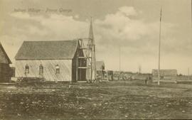
Side view of a wooden church, possibly under construction, and other buildings. Printed annotation on recto reads: "Indian Village- Prince George."

2009.7.1.165
·
Item
·
[ca. 1910]
Parte de Archdeacon W. H. Collison fonds
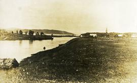
Three Indigenous men stand in a canoe poling their craft along a shoreline while one man sits and steers. An unidentified village is visible along the opposite shore.

2020.4.7.008
·
Item
·
2009
Parte de G. Gary Runka fonds
2012.13.2.01.03
·
Dossiê/Processo
·
[between 1970 and 1980]
Parte de J. Kent Sedgwick fonds
File consists of photocopies and notes relating to the boundary expansions of the city of Prince George since its incorporation. Includes a graph drawn by Kent Sedgwick regarding the addition of land and water each year of the boundary expansion and a "Proclamation" photocopy from the B.C. Gazette (23 Apr. 1953). Also includes 5 maps: "City of Prince George Boundary Expansions since Incorporation in 1915" (1979 or 1980); "City of Prince George" (Feb. 1979); "Map of Prince George" (between 1970 and 1985); "Study Area Boundaries" (Mar. 1977); and "City of Prince George" (Feb. 1972).
2012.13.2.01.05
·
Dossiê/Processo
·
1981-2011
Parte de J. Kent Sedgwick fonds
File consists of clippings, notes, and reproductions relating to the census boundaries across Canada. Also includes a map entitled "Canada: Federal Electoral Districts - 1987".
2012.13.2.02.24
·
Dossiê/Processo
·
[2007?]
Parte de J. Kent Sedgwick fonds
File consists of notes and reproductions relating to the Dominion Land Survey system. File primarily consists of photocopies of original township layout systems between 1881 and 1917 and printed secondary sources on the standardization of the Dominon Land Survey system in British Columbia and Alberta.
2012.13.2.02.25
·
Dossiê/Processo
·
1997-2006
Parte de J. Kent Sedgwick fonds
File consists of notes, clippings, and reproductions relating to contemporary and historical land surveying in British Columbia, includes material on Hunter Joseph who surveyed Quesnel to Salmon River in 1874; F.P. Burden and the surveying of the Cariboo District; and Mr. J.D. Pemberton, the colonial surveyor in 1851. File primarily consists of Kent Sedgwick's handwritten notes on land surveying in British Columbia and printed search results for the College of New Caledonia and BC Archives on land surveying. Includes: "Owning land: what you should know" pamphlet published by The Canadian Council of Land Surveyors (2004) and "Survey Systems in BC" email chain between Kent Sedgwick and John Whittaker, a B.C. Land Surveyor, discussing past land survey systems and surveyed areas in British Columbia (6 Oct. 2009).
2012.13.2.02.23
·
Dossiê/Processo
·
2001-2007
Parte de J. Kent Sedgwick fonds
File consists of notes and reproductions relating to pre-emption crown land grants between 1869 until 1912 in British Columbia, primarily in Prince George. File primarily consists of printed copies of pre-emptor maps of Prince George and region from the Royal BC Archives and Museum.
2012.13.2.02.20
·
Dossiê/Processo
·
1989-2011
Parte de J. Kent Sedgwick fonds
File consists of notes, reproductions, and letters relating to the street names in Prince George. Includes: "Canadian Permanent Committee on Geographical Names" typescript document; email from Ramona Rose to Kent Sedgwick (8 Dec. 2000); "Future entrance sign on Tyner Boulevard" typescript letter to Mr. Hamer from Ruth Iversen (10 Jan. 1995); "South Fort George gardens plan of subdivision" reproduced map depicting subdivision lots along the Fraser River in Prince George (2011); and "Porter Creek" letter from the Province of British Columbia to Kent Sedgwick (16 May 1989).
2012.13.2.02.29
·
Dossiê/Processo
·
1990
Parte de J. Kent Sedgwick fonds
File consists of notes and reproductions relating to the survey of Prince George. Includes material on survey plans, lots in Prince George, original town planning, subdivision plans, and Kent Sedgwick's handwritten notes on surveying and town planning in Prince George. File primarily includes photopied maps depicting town lots and planning in Prince George. Includes: "RE: Title Search for Fairgrounds" typescript letter from Kent Sedgwick to Dr. Dick Rowe (26 Apr. 1990) and "Map showing South Fort George, Fort George (Central) and the additions surveyed in 1910 or later" reproduced map from the Fort George Tribune newspaper.
2012.13.2.02.26
·
Dossiê/Processo
·
2002-2005
Parte de J. Kent Sedgwick fonds
File consists of notes, clippings, and reproductions relating to historical and contemporary natural resource surveys in British Columbia. Includes material on oil discovery, farming conditions, timber stands, the Alaskan Highway, and railway development. File predominantly consists of search results from the University of Northern British Columbia library, College of New Caledonia library, and Prince George Public Library regarding British Columbia's natural resource surveying.
2012.13.2.02.33
·
Dossiê/Processo
·
[1990?]
Parte de J. Kent Sedgwick fonds
File consists of maps and town surveys of early Prince George. Includes various reproduced 1915 maps and surveys depicting Prince George, Central Fort George, and Fort George: "Subdivision of part of Indian Reserve no. 1 lot 343 Cariboo District BC"; "Parcel Z map 1268"; "Plan of Subdivision lot 933"; "First addition to townsite of Central Fort George"; "Subdivision of lot 1511 Cariboo District BC"; "Townsite of Fort George" map originally made by R.H. Holland; "Plan of Subdivision of lot 1426 Fort George Collins Addition"; "Plan of subdivision of lot 932 Cariboo District"; and "Plan of subdivision of part of lot 2507."
2012.13.2.02.37
·
Dossiê/Processo
·
2001-2007
Parte de J. Kent Sedgwick fonds
File consists of notes and reproductions relating to Prince Arthur the Duke of Connaught, the third son of Queen Victoria who took the place of Governor General in Canada in 1911. Connaught Hill in Prince George was named in rememberance after Prince Arthur. File predominantly consists of printed websites and newspaper articles describing Prince Arthur, the Duke of Connaught, and his role as Governor General.
2012.13.2.02.34
·
Dossiê/Processo
·
1996-1998
Parte de J. Kent Sedgwick fonds
File consists of notes and reproductions relating to Brett & Hall landscape architecture and urban planning in Canada. File predominantly consists of photocopies of articles relating to urban planning, including "The Influence of Thomas Adams and the British New Towns Movement in the Planning of Canadian Resource Communities" by Oiva Saarinen; "Thomas Adams and the Commission of Conservation" by Alan H. Armstrong; "The Laying Out of Towns" by W.H. Dorsey; "The Relation of the City Engineer to Public Parks" by John C. Olmsted; "The Planning of Company Communities in the Lake Superior Mining Region" by Arnold R. Alanen; and "Planning the Canadian Environment" by L.O. Gertler.
2012.13.2.02.39
·
Dossiê/Processo
·
1996-2007
Parte de J. Kent Sedgwick fonds
File consists of notes, clippings, and reproductions relating to the City Beautiful movement across North America. File predominantly consists of photocopied articles: "The City Beautiful" by Fredrick Law Olmsted, Jr.; "The Plan of Chicago 1909" by Amy Diadamo; "Vancouver and the City Beautiful Movement" by Rodger Todhunter; "The Urbanization of America" by Blake McKelvey; and "The Rise of Modern Urban Planning" by Anthony Sutcliffe. File also includes an issue of the "Journal of the Society for the Study of Architecture in Canada", Vol. 32 No. 1 (2007).
2012.13.2.02.44
·
Dossiê/Processo
·
[ca. 2006]
Parte de J. Kent Sedgwick fonds
File predominantly consists of photocopies of newspaper articles, along with notes and reproductions relating to the development of the Prince George townsite and subdivision of Fort George, especially the area covered by Cariboo District Plan 1268. Includes material on investments and sale of lots in Prince George, Grand Trunk Pacific development in Prince George, and incorporation of the city of Prince George.
2012.13.2.02.45
·
Dossiê/Processo
·
1994-1998
Parte de J. Kent Sedgwick fonds
File consists of notes, clippings, and reproductions relating to the Millar Addition subdivision in Prince George.
2012.13.2.02.46
·
Dossiê/Processo
·
2001-2005
Parte de J. Kent Sedgwick fonds
File consists of notes and reproductions relating to the Hudson's Bay Company subdivision. Includes material on the subdivision, survey, and sale of lands in Fort George owned by the Hudson's Bay Company.
2012.13.2.02.49
·
Dossiê/Processo
·
[between 1980 and 1995]
Parte de J. Kent Sedgwick fonds
File consists of notes and reproductions relating to the planning of the Georges: South Fort George, Central Fort George, and Prince George.
2012.13.2.02.47
·
Dossiê/Processo
·
1986-2006
Parte de J. Kent Sedgwick fonds
File consists of notes, clippings, and reproductions relating to the South Fort George townsite. Includes "Name change from Glenora Park to Paddlewheel Park" typescript letter from Kent Sedgwick to The Mayor and Council (12 Sept. 1988).
2012.13.2.02.60
·
Dossiê/Processo
·
[between 1980 and 2010]
Parte de J. Kent Sedgwick fonds
File consists of a photocopy of "Journal and Report of Preliminary Explorations in British Columbia" originally written in 1872 by A.R.C. Selwyn in Geologic Survey Report of Progress for 1871-72.
2012.13.2.02.66
·
Dossiê/Processo
·
1987
Parte de J. Kent Sedgwick fonds
File consists of "South Fort George: A trip to the past", a heritage brochure prepared by the South Fort George Community Association.
2012.13.2.02.67
·
Dossiê/Processo
·
1968
Parte de J. Kent Sedgwick fonds
File consists of a pamphlet titled "The Fort Fraser-Fort George Bulletin Area" prepared by the Department of Lands, Forests, and Water Resources from the Province of British Columbia.
2012.13.2.03.05
·
Dossiê/Processo
·
1982-2007
Parte de J. Kent Sedgwick fonds
File consists of notes, clippings, and reproductions relating to the Fort George Canyon. Includes: "City of Prince George" typescript letter from Kent Sedgwick to Mr. Ron Drane, Manager of Pine Centre (7 June 1984) and "Fort George Canyon Hiking Trail" pamphlet published by the Fraser-Fort George Regional Museum (July 1984). Also includes photographs depicting the Fort George Canyon and men hiking the trail (1985).
2012.13.2.03.07
·
Dossiê/Processo
·
2001-2009
Parte de J. Kent Sedgwick fonds
File consists of notes and reproductions relating to Cottonwood Island in Prince George, formerly named Island Cache and Foley's Cache. Includes: "A brief history of Cottonwood Island Park" typed document by Kent Sedgwick (Nov. 2009).
2012.13.2.03.03
·
Dossiê/Processo
·
1979-1982
Parte de J. Kent Sedgwick fonds
File consists of letters relating to the Regional District of Fraser-Fort George geographical authority and heritage inventory. Includes: "Valemount Train Station" typed letter from Russell J. Irvine, the director of the Regional District of Fraser-Fort George, to Kent Sedgwick regarding the Valemount train station and ranch buildings at Mount Robson and applications for heritage trust (27 July 1982); "Heritage in Mackenzie" typed letter from the District of Mackenzie to Mr. Trimmer, the secretary of the Heritage Advisory Committee regarding heritage sites in Mackenzie (17 Apr. 1979); "Regional District" typescript document that is a list of heritage sites in the Regional District of Fraser-Fort George area; and "Fraser-Fort George Regional District" pamphlet depicting a map of the regional districts geographic area and list of authority districts.
2012.13.2.06.21
·
Dossiê/Processo
·
2005-2007
Parte de J. Kent Sedgwick fonds
File consists of notes and reproductions relating to a walking tour of the Millar Addition in Prince George.
2012.13.2.09.04
·
Dossiê/Processo
·
1986-2004
Parte de J. Kent Sedgwick fonds
File consists of notes, clippings, and reproductions relating to bibliographic references about the central interior of British Columbia. Includes: "Pioneers of the Central Interior" pamphlet from the Prince George Public Library (Nov. 1986) and "Manitoba Department of Tourism and Cultural Affairs" typescript letter from Shirlee Anne Smith to Frank Leonard (9 May 1980).
2012.13.2.11.03
·
Dossiê/Processo
·
1987-1996
Parte de J. Kent Sedgwick fonds
File consists of notes and reproductions relating to maps and creating maps of Prince George. File predominantly includes photocopies and reproductions of maps of Prince George and neighbourhoods in Prince George. Includes: "Planning division inventory of land use plans and sector plans" typescript document (5 Dec. 1989); "Prince George community planning council" typed letter to Kent Sedgwick attached to multiple maps depicting Prince George (11 Dec. 1996); and "Downtown revitalization committee map loan" typed document and photocopied maps lent to the Downtown Revitalization Committee from Kent Sedgwick (11 Dec. 1996).
2012.13.2.11.04
·
Dossiê/Processo
·
1969-1989
Parte de J. Kent Sedgwick fonds
File consists of maps and aerial photographs of Prince George. Includes: "Record of gift" typed document to Kent Sedgwick (10 July 1989); "Map showing topography of the incorporated area of Prince George" reproduction of a map depicting topography and lot areas of Prince George, originally drawn 1926; BC5553 No 237" aerial photo reproduction depicting Prince George [ca. 1980]; "Prince George September 1969" aerial photo reproduction (Sept. 1969); and "3rd and Johnson" reproduction of an aerial photo depicting 3rd Avenue and Johnson St in Prince George [ca. 1970]."