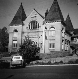
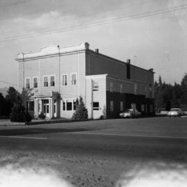
The item is an exterior photograph of the entrance to the College of New Caledonia at 3330 22 Avenue, Prince George.
Image depicts a number of trains in the CNR train yard taken from River Road in Prince George, B.C. Map coordinates 53°54'51.5"N 122°43'29.6"W
The photograph depicts a CN train engine in the interior of the roundhouse at the CN Railyard in Prince George, B.C. The train's identification number is 1369. Reproduction of photograph from 1984.
Photograph depicts the Canadian National Railway (CN) station at Hope, B.C.
Photograph depicts the Canadian National Railway (CN) repair shops at Port Mann. The caboose is receiving a spray paint job.
The photograph depicts the CN rail yard focusing on Garage 12 of the roundhouse and a CN train engine next to the building. Reproduction of photograph from 1984.
The photograph depicts a CN rail car at the CN roundhouse in Prince George, BC. Reproduction of photograph from 1984.
Photograph depicts a CN locomotive numbered 2693 with trees along both sides of the railway tracks.
Photograph depicts Canadian National Railway (CN) freight crossing Powell St. near Raymur Ave.
Photograph depicts the Canadian National Railway (CN) Chilliwack depot, looking north.
Image depicts the CN Building in Prince George, B.C.
Image depicts Upper Fraser residential area during demolition of town site. Map coordinates 54°06'51.6"N 121°56'26.3"W
Totem poles (crest poles?) stand in front of a line of houses. Blanketed canoes sit on beach in right foreground; forest in background.
Handwritten annotations on verso read: “Haida Encampment [crossed through with line]"; "Skidegate Queen Charlottes Islands / To illustrate Introduction / Introduction Trophies from a Song [Trail?] Page 1 Heading."
Photograph depicts large church to left of a tower structure. Power lines cross foreground, and other buildings can be seen in background.
Handwritten annotation on verso reads: "New Church Kincolith Nass River BC".
Handwritten annotation on verso reads: “working Minister on the Hill 1977”; photographer’s stamp on verso reads: “Please credit / Priere de mentionner - Health and Welfare Canada / Santé et Bien-être social Canada - Information Directorate / Direction de l’information”.
Large church stands behind white fence, unidentified man visible on front steps. Photograph depicts the first church built in Metlakatla, which was burned in a fire in 1901, and replaced in 1903.
Handwritten annotation on verso reads: "With love, from your two old friends JH [& AM Keen?]".
Photograph believed to have been taken at Government House, Victoria, B.C. Doorways and landscaping in background.
Close view of dock full of rows of nets and a few workers. Rows of bunkhouses on shore in background. Handwritten annotation in pencil on recto reads: “Port Essington B. C.”
Close up photograph of a large residential building in a freshly clear cut area. To the right of the main building is the church and an unidentified commercial building. Annotation on recto reads: "Prince Rupert, BC 1660."
Cassiar Asbestos Corporation Ltd opened a second mine in 1967 at what became the one-industry town of Clinton Creek, Y.T. File contains photographs depicting different areas of operations at Clinton Creek. Locations include the mine, plant, town, tailings pile, main office, the 40 Mile River, and surrounding area. Town photos depict the grocery store, cafeteria, medical clinic, school, auditorium residential area, Connell Street and power house. File also includes aerial photographs and images depicting forest fighting, photographers capturing the tailings pile, asbestos samples, mining machinery, staff offices, and operations in the mill, lab, and garage.
Additional photographs integrated into file depict Clinton Creek's surrounding area, and three slides of a tailing pile explosion believed to be Clinton Creek.
Cassiar Asbestos Corporation Ltd opened a second mine in 1967 at what became the one-industry town of Clinton Creek, Y.T. File contains photographs depicting progressive construction of buildings at the Clinton Creek mine, plant, townsite and powerhouse. Mine photos depict the crusher site and tramline station. Plant photos depict the dryer, fibre storage, mill, service, vault, and office buildings, as well as the dry rock storage tunnel, reclaim tunnel, and loading dock. Construction living quarters are depicted as well as the construction of residences at the townsite. The power house was built south of the town and plant, on the shore of the 40 Mile River. Some annotations describe the type of material being used for construction.
Image depicts a clearing at Island Cache.
The item is a photograph depicting the Prince George Coliseum from the outside. It shows a full parkin lot, a bus dropping people off and a layer of snow on the ground. The Civic Centre can be seen in the background. The annotation on the back states, "Coliseum Jan. 98."
Image depicts the Prince George Civic Centre.
Photograph depicts the city hall in Rossland, B.C. built in 1990, during its heyday.
Photograph depicts the city hall in Pitt Meadows in the Fraser Valley.
Photograph depicts the city hall at New Westminster on Victoria Day. The anvil battery is about to fire a 21 gun salute.
Photograph depicts the city hall at New Westminster on Victoria Day. The anvil battery firing round #3 of 21 gun salute.
Image depicts City Hall in Prince George, B.C.
The item is a photograph of a photograph depicting Prince George's City Hall circa. 1922 including an approximately 120 word write up describing its history. The building is approximately two stories high. There is an artillery cannon next to the building. A reflection of the photographer is barely visible in the photograph.
Image depicts Prince George City Hall. Map coordinates 53°54'46.3"N 122°44'41.9"W
The item is a photograph of a photograph depicting Prince George's City Hall circa. 1922 including an approximately 120 word write up describing its history. The building is approximately two stories high. There is an artillery cannon next to the building. A reflection of the photographer is barely visible in the photograph.
The item is a photograph of Citi Financial and an empty commercial building on 3rd Avenue in Prince George. Scotiabank building is visible in the background.
The item is a photograph of the CIBC Banking Centre on 3rd Avenue in Prince George.
Photograph depicts the Chute depot at mile 106.5 on the CPR line in the Carmi Subdivision. It is a totally isolated location, but not reachable by road. The photo shows the only surviving large building. The rail here is dated 1942.
Photograph depicts one of the churches on Denman Island.
Photograph depicts a church or school on the south side of Craigflower Rd. in Victoria B.C. It is near or on the Songhees Reserve.
Photograph depicts a church that was built of shaped logs on the territory of the Tsal'alh Nation on the road leading to Seton Lake. Church was derelict, but still held pews, plastic flowers and small shrines.
Photograph depicts a church on a reservation at Mosquito Creek in North Vancouver, B.C.
Image depicts a church on a hill somewhere in Seton Portage, B.C.
Photograph depicts the church of His Presence in Halfmoon Bay, Sechelt. It was built in 1962 by Cannon Greene, a former seafaring minister of the Columbia Coast Missions and the subject of a C.B.C. T.V. production in early April 1966.
Image depicts a church located near Mapes, B.C.
Image depicts the interior of a church, possibly one in or near Barkerville, B.C.
Image depicts the interior of a church, likely in Fort St. James, B.C.