Imprimir vista previa Cerrar

Mostrando 1067 resultados

Archival description
2000.19.1.191 · Item · 20 Sept. 1926-19 Oct. 1926
Parte de Prentiss Gray Collection

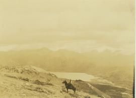
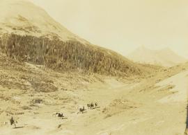
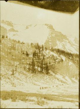
Photograph depicts a train of pack horses walking along a snowy trail across a snow-covered plateau. In the background a tree-covered mountain base is visible with snow-capped peaks rising up in the distance.

Two men loading up a pack horse
2000.19.2.55 · Item · 29 Aug. 1927-26 Sept. 1927
Parte de Prentiss Gray Collection

Photograph depicts two unidentified men loading up a pack horse in a field while two other men and several horses stand in the background.

Loading up a pack horse
2000.19.2.154 · Item · 29 Aug. 1927-26 Sept. 1927
Parte de Prentiss Gray Collection

Photograph depicts a man loading up pack horse with two other laden pack horses visible in the periphery of the image.

Gwen and Knox McCusker
2008.27.8.4 · Item · ca. 1946
Parte de Knox McCusker Collection

Photograph depicts Gwen and Knox McCusker standing outside, side by side. Caption on verso reads: “Knox & Gwen McCusker, late ‘40’s or early ‘50’s”.

Hagwilget Bridge Crosses Bulkley River
2009.5.1.70 · Item · [ca. 1900]
Parte de Taylor-Baxter Family Photograph Collection

Close view of bridge built with wooden planks, poles, and wires, braced from below, with triangles built into its frame. The bridge crosses Hagwilget Canyon on the Bulkley River, five kilometres from its confluence with the Skeena River. This is one of the many bridge structures that have crossed this location since at least 1859. Photograph was taken from one side of canyon, near bridge. Opposite canyon wall in background. Typed annotation glued to verso of photograph: "HAGWILGET - 'the gentle or quiet people'."

Hagwilget Bridge Crosses Bulkley River
2009.5.1.71 · Item · [ca. 1900]
Parte de Taylor-Baxter Family Photograph Collection

Photograph depicts two men and a horse on a bridge built with wooden planks, poles, and wires, braced from below, with triangles built into its frame. The bridge crosses Hagwilget Canyon on the Bulkley River, five kilometres from its confluence with the Skeena River. This is one of the many bridge structures that have crossed this location since at least 1859. Photograph was taken from a distance. Rocky riverbank in foreground, opposite shore in background behind bridge. Typed annotation in red ink on verso of photograph: "INDIAN BRIDGE, NEAR HAZELTON, B.C."

Taku River Survey - Kopoka River Rapids
2006.20.3.1 · Item · [between 29 August 1906 and 9 October 1906]
Parte de Northern BC Archives Historical Photograph Collection

Photograph depicts rocks among river rapids, opposite shore in background. Handwritten annotation on negative: "Rough water rap".

Image is one of 65 photos documenting a survey of the Canada-Alaska Boundary, Taku River area, May 23 to Oct. 15, 1906.
This particular photo is one of 13 found in original enclosure with the following handwritten annotation: "Kopoka River - river scenes Aug 29 to Oct. 9 [19]06". See also items 2006.20.3.2 - 2006.20.3.13.

Taku River Survey - Mountain Landscape
2006.20.3.2 · Item · [between 29 August 1906 and 9 October 1906]
Parte de Northern BC Archives Historical Photograph Collection

Photograph depicts valley; rocky area in foreground, mountains in background. Handwritten annotation on negative: "[M?] Glacier main camp".

Image is one of 65 photos documenting a survey of the Canada-Alaska Boundary, Taku River area, May 23 to Oct. 15, 1906.
This particular photo is one of 13 found in original enclosure with the following handwritten annotation: "Kopoka River - river scenes Aug 29 to Oct. 9 [19]06". See also items 2006.20.3.1 - 2006.20.3.13.

Taku River Survey - Canoe on Shore
2006.20.3.3 · Item · [between 29 August 1906 and 9 October 1906]
Parte de Northern BC Archives Historical Photograph Collection

Mountains stand behind water in background. Handwritten annotation on negative: "looking [over?] Kopoka".

Image is one of 65 photos documenting a survey of the Canada-Alaska Boundary, Taku River area, May 23 to Oct. 15, 1906.
This particular photo is one of 13 found in original enclosure with the following handwritten annotation: "Kopoka River - river scenes Aug 29 to Oct. 9 [19]06". See also items 2006.20.3.1 - 2006.20.3.13.

2006.20.3.11 · Item · [between 29 August 1906 and 9 October 1906]
Parte de Northern BC Archives Historical Photograph Collection

Photograph depicts two unidentified men on small boat with sail, opposite shore in background. Handwritten annotation on negative: "Prospectors on Taku Sailing".

Image is one of 65 photos documenting a survey of the Canada-Alaska Boundary, Taku River area, May 23 to Oct. 15, 1906.
This particular photo is one of 13 found in original enclosure with the following handwritten annotation: "Kopoka River - river scenes Aug 29 to Oct. 9 [19]06". See also items 2006.20.3.1 - 2006.20.3.13.

Taku River Survey - Kopoka River Rapids
2006.20.3.13 · Item · [between 29 August 1906 and 9 October 1906]
Parte de Northern BC Archives Historical Photograph Collection

Photograph depicts river water in foreground, mountains in background. Handwritten annotation on negative: "Rough Water, Kopoka".

Image is one of 65 photos documenting a survey of the Canada-Alaska Boundary, Taku River area, May 23 to Oct. 15, 1906.
This particular photo is one of 13 found in original enclosure with the following handwritten annotation: "Kopoka River - river scenes Aug 29 to Oct. 9 [19]06". See also items 2006.20.3.1 - 2006.20.3.12.

Taku River Survey - Men Loading Canoe
2006.20.3.16 · Item · [between 23 May 1906 and 15 October 1906]
Parte de Northern BC Archives Historical Photograph Collection

Photograph depicts three unidentified men loading canoe on river shore.

Image is one of 65 photos documenting a survey of the Canada-Alaska Boundary, Taku River area, May 23 to Oct. 15, 1906.
This particular photo is one of 8 found in original enclosure with the following handwritten annotation: "From main camp up Kopoka River. Scenes with persons in." See also items 2006.20.3.14 - 2006.20.3.21.

Taku River Survey - Man at Tent
2006.20.3.24 · Item · [between 23 May 1906 and 15 October 1906]
Parte de Northern BC Archives Historical Photograph Collection

Photograph depicts silhouette of unknown man standing in front of tent, trees in background. Poor image quality.

Image is one of 65 photos documenting a survey of the Canada-Alaska Boundary, Taku River area, May 23 to Oct. 15, 1906.
This particular photo is one of 13 found in original enclosure with the following handwritten annotation: "SOME OTHERS." See also items 2006.20.3.22 - 2006.20.3.34.

2006.20.3.25 · Item · [between 23 May 1906 and 15 October 1906]
Parte de Northern BC Archives Historical Photograph Collection

Unclear image of furry animal (wolverine?) moving among rocks.

Image is one of 65 photos documenting a survey of the Canada-Alaska Boundary, Taku River area, May 23 to Oct. 15, 1906.
This particular photo is one of 13 found in original enclosure with the following handwritten annotation: "SOME OTHERS." See also items 2006.20.3.22 - 2006.20.3.34.

2006.20.3.28 · Item · [between 23 May 1906 and 15 October 1906]
Parte de Northern BC Archives Historical Photograph Collection

Handwritten annotation visible on negative reads: "Valley of R. [Hills?] across Taku in distance."

Image is one of 65 photos documenting a survey of the Canada-Alaska Boundary, Taku River area, May 23 to Oct. 15, 1906.
This particular photo is one of 13 found in original enclosure with the following handwritten annotation: "SOME OTHERS." See also items 2006.20.3.22 - 2006.20.3.34.

Taku River Survey - Rapids
2006.20.3.29 · Item · [between 23 May 1906 and 15 October 1906]
Parte de Northern BC Archives Historical Photograph Collection

Photograph depicts white water rapids between rocks of river. Forest on opposite shore in background, tree branches in foreground.

Image is one of 65 photos documenting a survey of the Canada-Alaska Boundary, Taku River area, May 23 to Oct. 15, 1906.
This particular photo is one of 13 found in original enclosure with the following handwritten annotation: "SOME OTHERS." See also items 2006.20.3.22 - 2006.20.3.34.

2006.20.3.37 · Item · [between 23 May 1906 and 15 October 1906]
Parte de Northern BC Archives Historical Photograph Collection

Photograph depicts narrow waterfall in steep cliff, trees and bushes visible above. Handwritten annotation visible on negative: "Waterfall on way up Taku River."

Image is one of 65 photos documenting a survey of the Canada-Alaska Boundary, Taku River area, May 23 to Oct. 15, 1906. This particular photo is one of 7 found in original enclosure with the following handwritten annotation: "Around River Taku and main camp on same." See also items 2006.20.3.35 - 2006.20.3.41.

Taku River Survey - Iceberg
2006.20.3.40 · Item · [between 23 May 1906 and 15 October 1906]
Parte de Northern BC Archives Historical Photograph Collection

Photograph features iceberg floating in water, mountains on shore in background.

Image is one of 65 photos documenting a survey of the Canada-Alaska Boundary, Taku River area, May 23 to Oct. 15, 1906. This particular photo is one of 7 found in original enclosure with the following handwritten annotation: "Around River Taku and main camp on same." See also items 2006.20.3.35 - 2006.20.3.41.

Taku River Survey - Water Scene
2006.20.3.44 · Item · [between 23 May 1906 and 15 October 1906]
Parte de Northern BC Archives Historical Photograph Collection

Water spans foreground, wind-blown trees stand on shore in background. Mountains visible in distance.

Image is one of 65 photos documenting a survey of the Canada-Alaska Boundary, Taku River area, May 23 to Oct. 15, 1906. This particular photo is one of 5 found in original enclosure with the following handwritten annotation: "Boundary No.2 camera Sta. Twin Lake & Glacier.” See also items 2006.20.3.42 - 2006.20.3.46.

2006.20.3.45 · Item · [between 23 May 1906 and 15 October 1906]
Parte de Northern BC Archives Historical Photograph Collection

Photograph depicts valley in snowy mountain range. Handwritten annotation visible on negative: "Pan. From Camera Sta no w. looking at [?] Glacier."

Image is one of 65 photos documenting a survey of the Canada-Alaska Boundary, Taku River area, May 23 to Oct. 15, 1906. This particular photo is one of 5 found in original enclosure with the following handwritten annotation: "Boundary No.2 camera Sta. Twin Lake & Glacier.” See also items 2006.20.3.42 - 2006.20.3.46.

Taku River Survey - Water Scene
2006.20.3.46 · Item · [between 23 May 1906 and 15 October 1906]
Parte de Northern BC Archives Historical Photograph Collection

Water spans foreground, trees can be seen in water, trunks submerged. Opposite shore and mountains in background.

Image is one of 65 photos documenting a survey of the Canada-Alaska Boundary, Taku River area, May 23 to Oct. 15, 1906. This particular photo is one of 5 found in original enclosure with the following handwritten annotation: "Boundary No.2 camera Sta. Twin Lake & Glacier.” See also items 2006.20.3.42 - 2006.20.3.45.

2006.20.3.52 · Item · [between 23 May 1906 and 15 October 1906]
Parte de Northern BC Archives Historical Photograph Collection

Water spans foreground, mountains of opposite shore stand in background.

Image is one of 65 photos documenting a survey of the Canada-Alaska Boundary, Taku River area, May 23 to Oct. 15, 1906. This particular photo is one of 10 found in original enclosure with the following handwritten annotation: "From [Wahut?]-Azmuth and Koshu.” See also items 2006.20.3.47 - 2006.20.3.56.

2006.20.3.57 · Item · [between 23 May 1906 and 15 October 1906]
Parte de Northern BC Archives Historical Photograph Collection

River flows through rocky area, mountains visible in background.

Image is one of 65 photos documenting a survey of the Canada-Alaska Boundary, Taku River area, May 23 to Oct. 15, 1906. This particular photo is one of 9 found in original enclosure with the following handwritten annotation: "Pictures of different members of ‘our’ party.” See also items 2006.20.3.58 - 2006.20.3.65.

Taku River Survey - Men in Campsite
2006.20.3.58 · Item · 13 October 1906
Parte de Northern BC Archives Historical Photograph Collection

Photograph depicts miscellaneous items and supplies in front of white tent. Unknown man stands in foreground and a second man can be seen sitting in tent. Stand of trees in background. Handwritten annotation visible on negative: "[?] Oct 13".

Image is one of 65 photos documenting a survey of the Canada-Alaska Boundary, Taku River area, May 23 to Oct. 15, 1906. This particular photo is one of 9 found in original enclosure with the following handwritten annotation: "Pictures of different members of ‘our’ party.” See also items 2006.20.3.57 - 2006.20.3.65.

2006.20.3.64 · Item · [between 23 May 1906 and 15 October 1906]
Parte de Northern BC Archives Historical Photograph Collection

Photograph depicts two men walking with rope stretched between them close to shore of river, canoe floating behind them. Opposite shore crosses midground, mountains stand in background. Handwritten annotation visible on negative: "Gilroy & [Nellis?] - Kopoka River".

Image is one of 65 photos documenting a survey of the Canada-Alaska Boundary, Taku River area, May 23 to Oct. 15, 1906. This particular photo is one of 9 found in original enclosure with the following handwritten annotation: "Pictures of different members of ‘our’ party.” See also items 2006.20.3.57 - 2006.20.3.65.

2006.20.3.65 · Item · [between 23 May 1906 and 15 October 1906]
Parte de Northern BC Archives Historical Photograph Collection

Photograph depicts unknown man standing behind fish hung on a line. Tent and trees in background.

Image is one of 65 photos documenting a survey of the Canada-Alaska Boundary, Taku River area, May 23 to Oct. 15, 1906. This particular photo is one of 9 found in original enclosure with the following handwritten annotation: "Pictures of different members of ‘our’ party.” See also items 2006.20.3.57 - 2006.20.3.64.