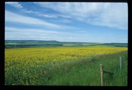
Image depicts a field in Giscome, B.C. On the right side of the image, in the background, is a grey strip that appears to be a mine, possibly the quarry at Eaglet Lake in Giscome, B.C. Map coordinates 54°03'52.9"N 122°22'10.0"W
Previous site of sawmill in Giscome, B.C. looking northwest. Map coordinates 54°04'19.7"N 122°22'04.7"W
Image depicts the former location of the Giscome mill foreman's house on the hill with Eaglet Lake in the background. Map coordinates 54°04'28.0"N 122°22'05.8"W
Image depicts a snowy road at an uncertain location.
Image depicts a two-room schoolhouse in Penny, B.C.
Image depicts a house with ivy growing over it. The location is uncertain.
Image depicts an old house with a torn up roof. The location is uncertain.
Image depicts an old house in Penny and a woman, possibly Sue Sedgwick, standing in front of it. The location is uncertain.
Image depicts an aerial view of a lake, and what appears to be a set of railway tracks running towards the mountains in the distance. The location is uncertain.
Image depicts an aerial view of several lakes and their surrounding areas at an uncertain location.
Image depicts what appears to be a small, narrow river, and mounds of snow. The location is uncertain.
Image depicts the Giscome bunkhouse in Giscome, B.C. Map coordinates 54°04'17.6"N 122°22'06.1"W
Image depicts the Giscome Community Hall in Giscome, B.C. Map coordinates 54°04'18.5"N 122°21'57.7"W
Image depicts the Giscome mill foreman's house on the hill. Map coordinates 54°04'28.0"N 122°22'05.8"W
Image depicts the Giscome, B.C. mill site looking west. Map coordinates 54°04'18.5"N 122°21'57.7"W
Image depicts four unidentified individuals standing on the bank of a river, possibly the Fraser, somewhere in or near Penny, B.C.
Image depicts a river, possibly the Fraser, near Penny, B.C.
Image depicts Kent Sedgwick sitting on the bank of a river. An old beehive burner is visible in the background. Located somewhere in or near Penny, B.C.
Image depicts what is possibly the community of Newlands, B.C.
Image depicts a barn full of hay and several cows, possibly near Newlands, B.C.
Image depicts the dairy farm in Giscome, B.C. Map coordinates 54°03'53.3"N 122°21'22.6"W
Image depicts a row of houses in Upper Fraser, B.C. Map coordinates 54°06'51.6"N 121°56'26.3"W
Image depicts the new Hansard Bridge. Map coordinates 54°04'57.9"N 121°51'10.1"W
Image depicts a street of shops at an uncertain location somewhere in the Peace River Regional District. A pink and blue building, possibly a theatre, is labelled "Lux."
Image depicts grass burning at an uncertain location in the Peace River Region.
Image depicts a cabin and several other buildings, possibly located in Hudson's Hope, B.C.
Image depicts what is either the Peace or Kiskatinaw River in Pine Valley, B.C.
Image depicts a view of Chetwynd, possibly from Highway 97.
Image depicts a river, possibly the Peace River.
Image depicts a group of individuals who appear to be examining a rock. It is possibly part of an educational trip.
Image depicts a large group of people examining the sediment layers in a rock face.
Image depicts a view of Pine Pass.
Image depicts a view of a sunset at an uncertain location, possibly in the Peace River Region.
Image depicts stuffed wildlife exhibits inside the Station Museum in Dawson Creek, B.C.
Image depicts a field of yellow plants at an uncertain location.
Image depicts an old, collapsing cabin which is sloped sideways. The location is uncertain.
Image depicts Sue Sedgwick and a dog standing next to an old, collapsing cabin which is sloped sideways. The location is uncertain.
Image depicts the road to Skagway, Alaska. Possibly located on the Klondike Highway in British Columbia with Tutshi Lake on the left.
Image depicts Atlin Lake as well as a small section of Atlin, B.C. The mountain is possibly Atlin Mountain.
Image depicts what appears to be a small community on the shore of a lake. The location is uncertain.
Image depicts Atlin Lake.
Image depicts a lake somewhere along what is possibly the Atlin Road to Atlin, B.C.
Image depicts a mountain somewhere along what is possibly the Atlin Road.
Image depicts numerous graves in the Atlin Cemetery.
Image depicts several unidentified individuals on a boat in the Miles Canyon near Whitehorse Y.T.
Image depicts the Robert Lowe Bridge, built in 1922, in the Miles Canyon near Whitehorse Y.T.
Image depicts a view of a forested, mountainous area and a river, somewhere along the White Pass railway. The slide is labelled "begin climb," suggesting the image was taken at the beginning of the White Pass Train's ascent into the mountains.
Image depicts a stream somewhere along the White Pass railway.
Image depicts a view of a forested valley in the mountains somewhere along the White Pass railway.