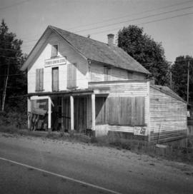
Photograph depicts a stone house on 17th St. and Esquimalt St. in West Vancouver, B.C.
Photograph depicts the Wheatsheaf Inn "pub" on the way to Cedar-by-the-Sea from Nanaimo, B.C.
Photograph depicts Chinatown in Duncan, B.C. on Vancouver Island.
Photograph depicts the Chinatown in Duncan on Vancouver Island.
Photograph depicts a grocery store on the main street of Pitt Meadows in the Fraser Valley.
Photograph depicts the water tower at B.C. Forest Products Ltd. Mill at Port Hammond, in the Fraser Valley.
Photograph depicts the corner building on West Georgia and Chilco St., facing Stanley Park in Vancouver B.C. View looking south across Georgia St.
Photograph depicts a church or school on the south side of Craigflower Rd. in Victoria B.C. It is near or on the Songhees Reserve.
Photograph depicts a former hotel, 300 yards from the former government wharf, in Squamish, B.C.
Photograph depicts an implement shed at Cloverdale in the Fraser Valley on the Pacific Highway.
Photograph depicts a disused general store at Coghlan, 5 miles southeast of Fort Langley in the Fraser Valley.
Photograph depicts the Windsor Hotel at Fort Steele, 10 miles northeast of Cranbrook. It was built in 1895 by Robert D. Mather and originally was called Dalgarno House. It is being renovated as a village museum.
Photograph depicts a general view of Coal Harbour in Vancouver, taken from its head in Stanley Park, looking east. The Bayshore Inn is shown on the extreme left of the image.
Photograph depicts an empty site at 1000 Beach Ave. in Vancouver, B.C.
Photograph depicts a view of Indian Arm, looking south from Granite Falls.
Photograph depicts the upper end of Coal Harbour, on the south shore looking southwest and taken from the dock of the Vancouver Shipyards Ltd.
Photograph depicts a view looking northeast towards Coal Harbour from Alberni St. (Chilco-Gilford block) with West Georgia St. in the middle distance.
Photograph depicts a general view of Coal Harbour in Vancouver, looking southeast and taken from Royal Vancouver Yacht Club premises. Photo shows the Bayshore Hotel on the extreme left.
Photograph depicts the construction of a new deep sea wharf on the site of an old Hastings mill in Vancouver, B.C. The forepart is to be dirt filled. The view is looking northeast.
Photograph depicts bollards for erection in new sea wall, to make outer face of the deep sea wharf being constructed at Dunlevey St. in Vancouver, B.C.
Photograph depicts the sluice gates off the Nicola River, on a ranch at Nicola village, 7 miles northeast of Merritt.
Photograph depicts a reaction ferry at Blackpool, near Clearwater on the north Thompson River, about 60 miles north of Kamloops. The car is being loaded on the east bank.
Photograph depicts the north shore of False Creek, looking west after a snowfall. Photo taken from the swing span of Cambie Bridge in Vancouver, B.C.
Photograph depicts an early spool donkey at the Cowichan Valley Forest Museum
Photograph depicts a scow with chips landing on the north shore of Vancouver harbour. There are Saskatchewan wheat elevators in the background.
Photograph depicts a general view of a Horne Bros. Ltd. shingle mill on #305 West Esplanade Rd. in North Vancouver.
Photograph depicts a view of the booming ground of the Horne Bros. Shingle Co. Ltd. On #305 West Esplanade Rd. in North Vancouver.
Photograph depicts an oxen powered log carrier with wheels that are approximately 10 feet in diameter. It is at Pioneer Park and Museum near Totem Lake, 3 miles north of Yahk and 30 miles east of Creston.
Photograph depicts a mine car at Moyie mine, at Moyie, 20 miles south of Cranbrook. The mine produced silver, zinc, and lead, and worked principally from 1900-1910. It is now disused.
Photograph depicts a horse drawn wagon in a garden at New Denver, Slocan Lake.
Photograph depicts a recently used steam crane, but driven by compressed air, at a former quarry at Granite Falls on the northeast end of the Indian Arm. The timbers on of the cabin were thick to withstand the blasting rock falls.
Photograph depicts a C.P.R. steam driven tracked crane at Revelstoke, BCIt was only marked "C.P. Service E.I."
Photograph depicts a traction engine at a ranch on Nicola Lake, near Merritt. The engine was made by Nichols-Shepard Co. at Battle Creek, Michigan and named the "Red River Special." It is undated and has 2 cylinders, side tanks, 16-10 horse power, wood burner, firebox 5 ft. long.
Photograph depicts an abandoned coal mine in Coal Creek, 5 miles east of Fernie, BCThe entrance to the mine is unusual and is 2/3rds up the mountainside. The mine was closed in 1959. Flat ground in foreground is littered with at least 100 mine tubs of approximately 3'0' gauge.
Photograph depicts a grave in the churchyard of Murray Church in Nicola, near Merritt. The church was built in 1876, which makes it one of the oldest churches in the interior of B.C. The gravestone shows a death in 1882, of a son aged 14.
Photograph depicts the mine buildings of the mine at Coal Creek that closed in 1959. The newer buildings date to circa 1930. Much of the standard gauge trackage of Morrissey, Fernie, and Michel railway (subsidiary of the Great Northern Railway) in mine area remains. The track between Coal Creek and Fernie has not been lifted.
Photograph depicts a truck at the Teepoortens Truck and Equipment Rentals Ltd., located at 950 West 6th Ave. in Vancouver, BC
Photograph depicts a horse drawn wagon at Kingbaker Creek on the southeast end of Mara Lake, south of Sicamous on highway 97A.
Photograph depicts one of the three remaining fire hydrants on location of the former Chinatown in Nanaimo, BCIt was provided and installed by the Chinese and not the city of Nanaimo. The hydrant had no identification marks.
Photograph depicts a rear view of 4 of the 6 traction engines in Nanton, Alberta. The left engine was built by Reeves and Co. in Columbus, Indiana, U.S. Its identification is #4438, it has 2 cylinder simple, and a roof. The next engine was built by Waterloo Mfg. Co. Ltd. in Waterloo, Ontario and has a single cylinder. The third engine was built by Sawyer Massey. The engine on the right side is a Gaar Scott, built in 1913, and has 25 horsepower on the drawbar and 75 horsepower on the belt.
Photograph depicts the C.P.R. terminal in Vancouver. A C.P.R. switcher is collecting cars from the "Princess of Vancouver" at about 7 p.m.
Photograph depicts the C.P.R. station at Golden, B.C. The view is looking east.
Photograph depicts the C.P.R. station at Merritt, halfway between Spences Bridge and Brockmere Junction. The line is in active use.
Photograph depicts the C.P.R. westbound freight train at passing loop at Illecillewaet, between Rogers Pass and Revelstoke. The April 25, 1965 CPR Employee timetable lists the mileage at Illecillewaet as 98.2 with a siding capacity of 85 cars.
Photograph depicts the C.P.R. yards on Cambie St. in Vancouver, B.C. The view is looking west with False Creek on the left (out of the picture), after a snowfall.
Photograph depicts the unused C.P.R. Shawnigan Lake section house on the Esquimalt and Nanaimo Railway. It is 27.8 miles outside Victoria.
Photograph depicts a C.P.R. wrecking crane at the Vancouver station.
Photograph depicts a coach stock in the C.P.R. False Creek yards in Vancouver, B.C.
Photograph depicts the C.P.R. ferry slip at Kaslo on Kootenay Lake. It is in regular use.
Photograph depicts a C.P.R. barge on Slocan Lake, travelling north just after leaving Slocan. It holds a complete train including a locomotive, eight cars, and a caboose.