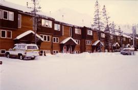
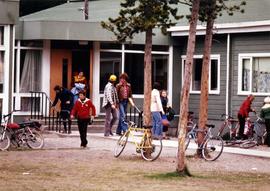
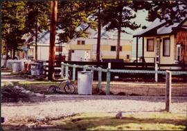
Photograph depicts residences and fenced front yards to left of street, trash cans in front. Small tricycle, camping trailer, power poles, and trees also visible.
Photograph depicts trees and pickup trucks in front of long building speculated to be an apartment residence.
Photograph depicts vehicles parked in driveways and on street to right of mobile homes. Mountain base in background.
Photograph depicts row of houses on either side of street in midground. Forest trees in foreground, mountains in background.
Photograph depicts unidentified men and women in front of yellow building with the signs "POST OFFCE / BUREAU DE POST / CASSIAR, B.C.", "NO PARKING". Three cars (one with siren on top) can be seen in foreground; forest in background.
Photograph depicts group of men, women, and children exiting main entrance of building believed to be the school at Cassiar, B.C. Trees and bicycles in foreground.
Photograph depicts four unidentified individuals walking in front of Cassiar Private Hospital. Sign in foreground reads "VISITING HOURS EVERY DAY / 2 PM - 4 PM / 7 PM - 8 PM".
Photograph depicts group of children standing in front of diving board, watching a peer dive into water below. Group of swimmers visible in background below domed roof of pool.
Photograph depicts two unidentified men using weight training equipment in indoor gymnasium. Weights and other equipment in background.
Photograph depicts two unidentified men playing tennis in foreground. Buildings stand in midground, including what appears to be the All Saints Anglican Community Church. Forest and mountain in background.
Photograph depicts church believed to be the All Saints Anglican Community Church at Cassiar, B.C. Trees and fence in foreground, forest and mountain in background.
Photograph depicts interior of church believed to be the All Saints Anglican Community Church at Cassiar, B.C. Table and pulpit in foreground, pews and door in background. Stained glass windows line both sides of the building.
Photograph depicts large auditorium, seats filled with unidentified individuals (mostly children). Rounded stage in foreground, curtain on wall in background. This building was built in the late 1970s and belonged to the community's cultural society.
Photograph depicts what appears to be a Euclid ore haulage truck at entrance of building speculated to be the truck dumping station at crusher plant in mine.
Photograph depicts two unidentified men in coveralls and hard hats, working in garage. Blasthole drill stands behind them in midground, walls in background.
Photograph depicts two unidentified men wearing coveralls, hard hats, and headphones, while working at table in garage. Blasthole drill stands behind them in background.
Mill building in left midground. Conveyor believed to be leading to tailings pile can be seen in foreground. Valley and mountains in background.
Plant buildings stand in midground. Conveyor believed to be leading to tailings pile can be seen in foreground. Valley and mountains in background.
Photograph depicts Ruston Hornsby diesel engines which turned the generators in the power house on the Cassiar plant. Two unidentified men wearing coveralls can be seen in image.
Photograph depicts unidentified man standing on Ruston Hornsby diesel engine which turned the generators in the power house on the Cassiar plant.
Photograph depicts two unidentified men standing on Ruston Hornsby diesel engine which turned the generators in the power house on the Cassiar plant.
Photograph depicts large trailer truck parked at what is believed to be the loading station on the Cassiar plant (possibly in mill building).
Photograph depicts two large tanks with Cassiar logo on front, labeled "1" and "2". Road in foreground, garage in background. Mountain base also visible in background.
Photograph depicts the old company store located at corner of Connell Driver and Creery Street. Retail store was located under company cafeteria "the Cookery", with butcher shop in back. The Cookery was known for serving good food and providing excellent service.
Photograph depicts a building with a truck parked in front on the corner of Connell Drive and Creery Street.
Photograph depicts large building behind power lines, car in right foreground.
Photograph depicts four large buildings behind power lines, believed to be located on Malozemoff Avenue. Trucks in foreground, forest and mountains in background.
Photograph depicts a log cabin in the woods with a small porch and moose antlers hanging from the roof. Beside the house is a small log shed.
Photograph depicts wood houses behind stand of trees in Cassiar valley. Truck, power poles, and road in foreground, mountains in background. Typed caption below photo in original duotang album: "Two Bedroom Pan-Abode Houses - Cassiar Townsite". Handwritten annotation on verso: "Sept 1954".
Photograph depicts a log cabin in the woods with a small porch and moose antlers hanging from the roof.
Photograph depicts group of eight men standing on front steps of Cassiar's Main Office building. Top, left to right: Ken A. Creery, John Drybrough. Middle, left to right: John E. Kennedy, Tam Zimmermann. Bottom, left to right: Fred Martin Connell, George Washington Smith, W. Harold Connell, Charles Rainforth Elliot. Windows and doors to office in background, flowers in bottom right foreground. Photo believed to have been taken on the same day as items 2000.1.1.4.3.4 - 2000.1.1.4.3.6.
Photograph depicts group of eight men standing on lawn in front of building known as "House 130" or "Director's Lodge" (see item 2000.1.1.3.19.88). Left to right: Nick Gritzuk, Charles Rainforth Elliot, Jack Christian, W. Harold Connell, Plato Malezemoff (from Newmont Mining), Tam Zimmermann, Ken A. Creery, Fred Martin Connell. Daffodils and tulips planted in foreground, trees and mountains in background. Most men featured in photo are believed to be members of Cassiar's Board of Directors.
Photograph depicts group of nine men standing on lawn in front of building known as "House 130" or "Director's Lodge". Left to right: Andre Beguin, unknown, Charles Rainforth Elliot, Jack Christian, W. Harold Connell, Plato Malezemoff (from Newmont Mining), Tam Zimmermann, Ken A. Creery, Fred Martin Connell. Daffodils and tulips planted in foreground, trees and mountains in background. Most men featured in photo are believed to be members of Cassiar's Board of Directors; Beguin was a General Superintendent.
Photograph depicts group of eight men standing on lawn in front of building known as "House 130" or "Director's Lodge". Left to right: Nick Gritzuk, Charles Rainforth Elliot, W. Harold Connell, Jack Christian, Fred Martin Connell, Ken A. Creery, Plato Malezemoff (from Newmont Mining), Tam Zimmermann. Trees and mountains in background. Most men featured in photo are believed to be members of Cassiar's Board of Directors.
Photograph depicts group of eight men standing on lawn in front of building known as "House 130" or "Director's Lodge". Left to right: Nick Gritzuk, Charles Rainforth Elliot, W. Harold Connell, Jack Christian, Fred Martin Connell, Ken A. Creery, Plato Malezemoff (from Newmont Mining), Tam Zimmermann. Gritzuk appears to be pointing at photographer. Trees and mountains in background. Most men featured in photo are believed to be members of Cassiar's Board of Directors.
Photograph depicts group of eight men standing on lawn in front of building known as "House 130" or "Director's Lodge". Left to right: Nick Gritzuk, Charles Rainforth Elliot, Jack Christian, W. Harold Connell, Plato Malezemoff (from Newmont Mining), Tam Zimmermann, Ken A. Creery, Fred Martin Connell. Elliot appears to be comparing height with Gritzuk. Trees and mountains in background. Most men featured in photo are believed to be members of Cassiar's Board of Directors.
This blueprint depicts the general layout of the recreational centre. Top-down, side and front perspectives are used. The ground floor, second floor, outside walls and stage layouts are shown.
This blueprint depicts the outside layout of the recreation centre and includes its north, south, east and west elevations. Details are included regarding the materials to be used for construction.
This blueprint depicts the detailed plans for the recreational centre's entrance hall. There are details pertaining to the elevation of entrance doors, the overall plan of the entrance hall, the upper level staiwell as well as handrailing details.
This blueprint depicts a cross-section layout of the recreational centre which includes a 1/4 scale drawing of a wall unit.
This blueprint depicts the overall framing structure of the recreational centre. Details include a cross section layout of the recreational centre with relevant framing dimensions, the locations and instructions for assembly as well as types of framing materials to be used.
This blueprint depicts the overall layout of the heating and ventilating units to be used for the first and second floor of the recreational centre. Details include the locations of fans, boilers, ducts and exhausts as well as typical heating connector connections and the plumbing layout.
This blueprint depicts the gymnasium lighting layout. Also shown is an isometric view of the air supply unit piping as well as a ventilating unit automatic control diagram. Included are detailed notes regarding system desriptions, its plan and layout as well as directions for the automatic control of the ventilation unit and heating systems.
This blueprint depicts the general layout of the recreational centre. Top-down, side and front perspectives are used. The ground floor, second floor, outside walls and stage layouts are shown. Annotations in gold pen and pencil regarding clarification and changes to certain details are included. Numerical annotation at the bottom right hand of plan imposed new numbering system (3002/09/06).
This blueprint depicts the outside layout of the recreation centre and includes its north, south, east and west elevations. Details are included regarding the materials to be used for construction. Annotations in gold pen and pencil regarding clarification and changes to certain details are included. Numerical annotation at the bottom right hand of plan imposed new numbering system (3002/09/07).
This blueprint depicts the detailed plans for the recreational centre's entrance hall. There are details pertaining to the elevation of entrance doors, the overall plan of the entrance hall, the upper level staiwell as well as handrailing details. Annotations in gold pen and pencil regarding clarification and changes to certain details are included. Numerical annotation at the bottom right hand of plan imposed new numbering system (3002/09/08).
This blueprint depicts a cross-section layout of the recreational centre which includes a 1/4 scale drawing of a wall unit. Annotations in gold pen and pencil regarding clarification and changes to certain details are included. Numerical annotation at the bottom right hand of plan imposed new numbering system (3002/09/09).