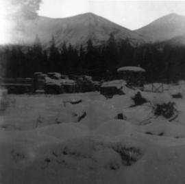
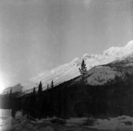
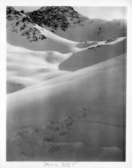
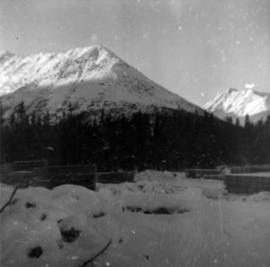
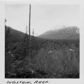
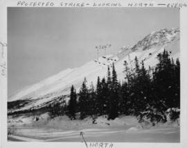
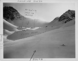
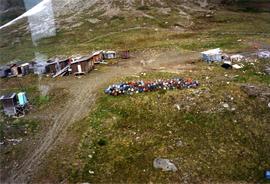
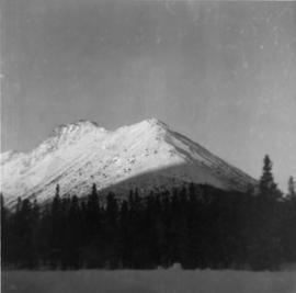
Photograph depicts snow-covered mountain north of townsite, partially covered in shadow. Photo taken with sun at highest point in the sky. Plant site clearing in foreground, trees behind clearing.
Photograph depicts five trucks and Eimco loader in snow-covered campsite. Photo taken facing south, forest and snow-covered mountains in background.
Photograph depicts McDame Creek road, snow-covered and taken from center of road, 1.5 miles from the early construction camp at Cassiar. Trees and mountains in background.
Photograph depicts the caboose office: a small wooden structure with flat roof and one door. Snow pathways and power pole in foreground, trees and hills in background.
Photograph depicts three men building garage foundation in snow-covered plant site. Truck to right of men, wood fence structure in foreground, Asbestos Valley in background.
Photograph depicts McDame Mountain from view of the early construction campsite at Cassiar. Trees in foreground.
Photograph depicts glacier on McDame Creek road, 1.5 miles from the mine at Cassiar. Snow-covered trees in background.
Photograph depicts snow-covered Asbestos Valley, slightly north of asbestos deposit.
Photograph depicts snow-covered Asbestos Valley, taken from mountain road looking northwest.
A collection of photographs from the site that Cassiar was being built in the early 50s. Photos depict lumber piles, early camp area, the first buildings, mountains, and the creek.
Along with this collection there are a set of images also from the early Cassiar site mainly depicting a dirt road and various individuals and machinery along it.
Photograph depicts approximately six lumber piles in the northwest corner of snow-covered plant site. Forest and snow-capped mountains in background. Photo taken facing west.
Photograph depicts tent structures among trees at the temporary Cassiar construction camp. Taken from future site of garage building, looking northwest, snow-capped mountain in background.
Photograph depicts a log bridge across Quartz Creek taken from shore. Trees in background on opposite shore, snow capped mountains barely visible behind trees.
Photograph depicts three small camp structures in dirt landscape: one trailer, one wooden building and one tent building. Logs and wood pile in foreground, forest and snow-capped mountain in background.
Photograph depicts a dirt roadway in wooded area. Snow capped mountains in background.
Photograph depicts a pile of industrial material in a wooded area. Pile includes what is believed to be cardboard boxes and lumber planks. Trees in background, mountains barely visible behind trees.
Photograph depicts a rocky clearing in a wooded area, snow-capped mountain in background. Outline of mountaintop is sketched on photograph in pencil, projected mining area is outlined in blue ink.
Photograph depicts the wooded area of the Cassiar valley. The projected plant site is outlined in blue ink. Trees and bushes in foreground, snow-capped mountains in background.
Photograph depicts the projected mining area of Asbestos Mountain, taken during the expedition of George Edzerza's party and their exploration of the future mine at Cassiar.
Handwritten annotations on verso in blue ink describing sections of photograph which have been pointed to or outlined in blue ink: "PROJECTED STRIKE - LOOKING NORTH - OVER -->" "<500'>" "NORTH".
Handwritten annotations in black ink on verso also outline areas and mark areas with "x".
Handwritten annotation on recto in blue ink: "No. 2. This is the continuation of the ore zone, over the top of the mountain, away from the 'fluff'' deposit."
Photograph depicts the projected mining area of Asbestos Mountain, taken during the expedition of George Edzerza's party and their exploration of the future mine at Cassiar.
A collection of 10 photographs of documented exploration in the early 1950s in and around the Cassiar area. Noted locations are Quartz Creek, Mocassin Mines, Blue River Bridge and the Alaska Highway.
Photograph depicts a dirt road 6 miles from the Alaska Highway.
Photograph depicts a bridge at Blue River taken from shore.
Photograph depicts the projected mining area of Asbestos Mountain, taken during the expedition of George Edzerza's party and their exploration of the future mine at Cassiar.
Handwritten annotation on verso in blue ink describing sections of photograph which have been pointed to or outlined in blue ink: "LOOKING SOUTH" "ORE ZONE <--500'--> ORE IN PLACE" "FLUFF AREA" "SOUTH^".
Photograph depicts a truck on a newly cleared dirt road in a mountain pass and a wooded area.
Photograph depicts a wooden structure in a gravel landscape. Truck with open door in foreground, forest and snow capped mountains in background. Mounds of gravel visible behind structure.
Photograph depicts steel drums and wooden buildings at an exploration camp in the Kutcho Creek valley area of B.C. The camp was set up by a crew led by Cassiar's Chief Geologist Bill Plumb. An arrow points to a possible burial site.
This file contains a collection of photographs of Elsa Mine and Venus Mine in the Yukon Territories that were operated by Equipment United Keno Hill, and were subsequently closed after Keno shut down operations in 1989.
It can be assumed that the Cassiar mine was looking at the equipment at Elsa and Venus mine for purchase as the collection depicts various machinery including: shotcrete machine, long hole drill, auger screw, compressed air powered generator, Cat engine, scooptram and slusher from Elsa Mine; and an empty trailer, first aid trailer, compressed air powered tugger, air receivers, cooling system, twist air compressors, and a bit sharpener from Venus Mine.
A collection of photographs of the early exploration exhibitions in the asbestos mountains area.
This is a collection of photographs from a Trip Report to Eureka Asbestos Cement Plant in Mexico by A.C. Beguin, General Superintendent, in 1958. It was primarily a "contact" visit by Cassiar Co. to the Mexican plant as they were new customers.
The photographs depict various in and around the plant, including: suburbs around plant, entrance to plant, Mexican people making "tortilla," discussions with General Manager Sr. Batis and plant engineer Sr. Gomez, Cassiar fibre reading for blending, weighing and batching area, sludge tank, pipe machine , pipe storage, hammer mill, dust tube filter, sheets going through sizing, shipments, construction of a water storage tank, workmen at work, tank area, loading trucks, testing machine, and final percentages of fibre in products.
Photograph depicts George Edzerza , R. T. Gilman, Bill Mossoh, and Pete Hamlin with gear and wearing snowshoes in the Asbestos Mountain area. It is believed that the photograph portrays their exploration of the future mine at Cassiar.
Photograph depicts three men on Asbestos Mountain who are believed to be members of George Edzerza's expedition party during an exploration of the future mine at Cassiar.
Handwritten annotation on verso in blue ink describing sections of photograph which have been pointed to or outlined in blue ink: "LOOKING SOUTH" "ORE ZONE <500' [?] >" "'FLUFF' AREA" "2 MEN" "1 MAN" "OVER -->"
Handwritten annotation on recto in blue ink: "The shaded areas do not indicate 'fluff' necessarily - They are shadows from mountains. The size of the men will give you some indication of the distance".
Photograph depicts steel drums and wooden buildings at an exploration camp in the Kutcho Creek valley area of B.C. The camp was set up by a crew led by Cassiar's Chief Geologist Bill Plumb.
Photograph depicts the dogsled team of George Edzerza's expedition party on Asbestos Mountain during an exploration of the future mine at Cassiar.
Photograph depicts three men on Asbestos Mountain who are believed to be members of George Edzerza's expedition party during an exploration of the future mine at Cassiar.
Photograph depicts man believed to be Matt Bell standing in Kutcho Creek exploration camp. The camp was set up by a crew led by Cassiar's Chief Geologist Bill Plumb. Tents on either side, wood structure in background. Sign on wood post: "PLUMB BLVD."
Photograph believed to have been taken near Kutcho Creek, BC during an outside exploration trip led by Cassiar's Chief Geologist Bill Plumb. Bill stands to left of man believed to be Matt Bell in right foreground. Bulldozer works along talus slope in left foreground.
Photograph depicts valley in Kutcho Creek area, exploration camp in distance at foot of hill. The camp was set up by a crew led by Cassiar's Chief Geologist Bill Plumb.
Bulldozer works along talus slope in centre of image. Photograph believed to have been taken near Kutcho Creek, BC during an outside exploration trip led by Cassiar's Chief Geologist Bill Plumb.
Photograph depicts valley in Kutcho Creek area, exploration camp in distance. Body of water in foreground, mountains in background. The camp was set up by a crew led by Chief Geologist Bill Plumb.
Photograph depicts a valley in the Kutcho Creek area with an exploration camp in the distance at the foot of a hill. The camp was set up by a crew led by Cassiar's Chief Geologist Bill Plumb.
Photograph depicts an exploration camp in the valley at the Kutcho Creek area in B.C. The camp was set up by a crew led by Cassiar's Chief Geologist Bill Plumb.
This photograph is an aerial depiction of what is believed to be a Certain Teed factory in the United States. Certain Creed is a manufacturing company that supplies building materials. They have been in operation since 1904 to present. This photograph was found along with invoices, shipping orders and correspondence between Certain Teed and Cassiar.
This collection of photograph is a Cassiar trip report to Weldotron Inc. Industrial Packaging Systems in Piscataway, New Jersey to look at the shrink wrap system. The ten photographs depict the wrap applicator, bag maker placer, feed side of wrap applicator, shroud wrap machine, and before and after packaged asbestos. One photograph is of the Kellogg Plant in Michigan depicting forklifts. There is also a commercial photograph of the "Weldotron Pallet Pak Shrouder & Shrink Tunnel for shrink wrapping pallet loads."
This is a collection of photographs from Liverpoool UK for the commercial promotion of a barrel. They are professional depictions of all sides and angles of the proposed barrel that Cassiar was exploring to obtain. It can be assumed that this barrel would have been used in the powerhouse as the original file was titled Powerhouse and contained powerhouse records for development.
Various photographs of equipment that Cassiar was researching to potentially purchase.
One photograph of proposed conveyor, to be used to transport material to the stockpile in 1957. One photograph of DUX Jump Tracker from DUX Machinery Corporation in 1976. Four photographs of George O. Hill Supply ltd. "Hill Belt Cleaner" (a rotary cleaner) in 1985. One photograph of George O. Hill "Poly-Teflon Conveyor Roller" in 1991. Three photographs of an overhead container crane from Kingsway Engineering Corporation in 1978. Two photographs of equipment from Sintra for Underground tunneling machinery in 1985. Two photographs (attributed to Ward&Davidson photography in Montreal) of Denovan machine from Victory Tool & Machine Co. Ltd. Two photographs of minpack system of cable from Mincon Inc. in April 1990. Three photographs of Transwest Dynequip from Por Coquitlam in 1990, with a note stating "To big for our need." Four photos of Euclid Trucks. Four photos of proposed Grader for mine from "Champion." Seven photos of Reed Guncrete equipment for shotcrete in 1989.