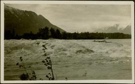
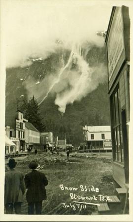
Print preview Close

Showing 4134 results

Archival description
3619 results with digital objects Show results with digital objects
Snow slide in Stewart, BC
2011.13.35 · Stuk · 7 July 1911
Part of Parker photograph collection

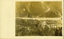
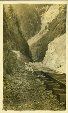
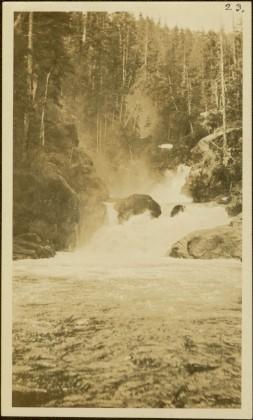
Street view photograph of two individuals watching the snow slide down one of the mountains surrounding Stewart, BC. Printed annotation on recto reads: "Snow Slide Stewart B.C. July 7/11."

Bitter Creek Glacier
2011.13.55 · Stuk · [ca. 1910-1930]
Part of Parker photograph collection

Wide angle perspective of the Bitter Creek glacier, with trees visible in the foreground. Printed annotation on recto reads: "Hughes #22 Bitter Creek Glacier."

2009.7.1.004 · Stuk · [ca. 1915]
Part of Archdeacon W. H. Collison fonds

Photograph depicts the sons and daughters of Marion and Archdeacon W.H. Collison, and one unidentified man. Buildings can be seen on shore in background.

Handwritten annotation on verso reads: "Collison family at camp (Portland Canal) Max, ?, Henry, Elsie, Arthur, Alice, Herbert".

2009.7.1.016 · Stuk · [ca. 1910]
Part of Archdeacon W. H. Collison fonds

Photograph depicts Marion and William Henry Collison standing on left with shovel, Bertha Collison on right, and young Muriel and Katherine Collison in centre with shovel (eldest daughters of W.E. Collison). Wood buildings cross midground, trees and hills visible in background.

Handwritten annotation on verso reads: "Garden at Kincolith / Grandad, Grannie / Mimi, Katie / Mother".

2009.7.1.055 · Stuk · [between 1903 and 1914]
Part of Archdeacon W. H. Collison fonds

Photograph depicts large buildings on shore. Three unidentified individuals can be seen walking on dock in foreground.

Printed on image: "METLAKATLA B.C. / McRAE BROS"; handwritten annotation on verso reads: "A section of Metlakahtla, showing Church & Schoolhouse." See also item 2009.7.1.58 for similar image also featuring the new church building at Metlakatla, B.C.

2009.7.1.061 · Stuk · [ca. 1873 - ca. 1920]
Part of Archdeacon W. H. Collison fonds

Photograph depicts a man and woman standing on steps to a round tower in fenced area. Roofs of other buildings can be seen below on right; water and shore visible in background.

Printed on image: "Indian Jail, Metlatkla".

2009.7.1.140 · Stuk · [ca. 1925?]
Part of Archdeacon W. H. Collison fonds

Group of six men sit and stand on small boat close to shore. Rev. W.E. Collison stands on far right (son of Marion and Archdeacon W.H. Collison).

Handwritten annotation on verso reads: "Dr. Macdonald Med officer (Kincolith) / Dr. [McQuarrie?] Med officer Victoria / Steven Clayton Native boat owner / Capt. Bary - Insp. of Indian Schools / W.E. Collison Indian agent. / Inspection trip to villages of upper Nass River".

2009.7.1.150 · Stuk · [ca. 1878 - ca. 1915]
Part of Archdeacon W. H. Collison fonds

Photograph features a steep cliff across water, rocky shore in foreground.

Handwritten annotation on verso reads: "Up the 'Big Creek' at Kincolith B.C. Rock face called 'the place of echoes' by the Indian people."

Shoreline Petroglyphs
2009.7.1.174 · Stuk · [ca. 1925]
Part of Archdeacon W. H. Collison fonds

Petroglyphs featuring coppers painting onto a rock face next to a lake.

Handwritten annotation in pencil on verso reads: “As seen from the R.R. track. By Harlan I. Smith. 4 poles E of 92 mile or about 1 ½ meter E. of Tyce, B.C., Red Pictograph, Note: head above and to the right at the left of log top in shadow of cedar.” Stamped annotation on verso reads: “Department of Mines Geological Survey Photographic Division, January 21 1926” – in pen above this stamped date is written “7-10-1925”.

P.G. Plan
2012.13.1.001 · Deelreeks · [between 1985 and 2003]
Part of J. Kent Sedgwick fonds

File contains slides depicting maps and site plans for the city of Prince George.

View from Gunn Point
2012.13.1.3.058 · Stuk · Nov. 1979
Part of J. Kent Sedgwick fonds

Image depicts a view of Prince George from Gunn Point in the L.C. Gunn Park looking north. Map coordinates 53°54'26.2"N 122°43'35.8"W.

View from Gunn Point
2012.13.1.3.062 · Stuk · Nov. 1979
Part of J. Kent Sedgwick fonds

Image depicts a view of Prince George from Gunn Point in the L.C. Gunn Park looking north. Map coordinates 53°54'26.2"N 122°43'35.8"W.

View from Gunn Point
2012.13.1.3.063 · Stuk · Nov. 1979
Part of J. Kent Sedgwick fonds

Image depicts a view of Prince George from Gunn Point in the L.C. Gunn Park looking north. Map coordinates 53°54'26.2"N 122°43'35.8"W.

View from Gunn Point
2012.13.1.3.066 · Stuk · Nov. 1979
Part of J. Kent Sedgwick fonds

Image depicts a view of Prince George from Gunn Point in the L.C. Gunn Park looking north. Map coordinates 53°54'26.2"N 122°43'35.8"W.

View from Gunn Point
2012.13.1.3.067 · Stuk · Nov. 1979
Part of J. Kent Sedgwick fonds

Image depicts a view of Prince George from Gunn Point in the L.C. Gunn Park looking north. Map coordinates 53°54'26.2"N 122°43'35.8"W.

Nechako Cutbanks Trail
2012.13.1.3.091 · Stuk · 12 Oct. 1989
Part of J. Kent Sedgwick fonds

Image depicts the cutbanks on the other side of the Nechako, taken from the nature trail at Island Cache. Map coordinates 53°55'34.6"N 122°45'52.4"W

Prince George
2012.13.1.3.134 · Stuk · 12 Oct. 1989
Part of J. Kent Sedgwick fonds

Image depicts Prince George, possibly with the Northwood Pulpmill in the background.

Prince George Sawmill
2012.13.1.3.159 · Stuk · Nov. 2000
Part of J. Kent Sedgwick fonds

Image depicts Prince George Sawmill taken from across the Nechako River looking southwest. Map coordinates 53°56'00.0"N 122°44'29.7"W

2012.13.1.3.168 · Stuk · Mar. 2003
Part of J. Kent Sedgwick fonds

Image depicts an aerial view of a Prince George residential section between Highway 97, Carney Street and 10th Ave looking north. Map coordinates 53°54'54.0"N 122°46'00.4"W