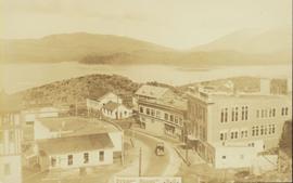
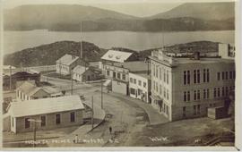
Elevated street view of Fulton Street in Prince Rupert, BC. City Hall is in the left foreground. Hills and water are visible in the background. Printed annotation on recto reads: "Fulton St. Prince Rupert. B.C. W.W.W."
Elevated street view of Fulton Street in Prince Rupert, BC. City Hall is in the left foreground. Hills and water are visible in the background. Printed annotation on recto reads: "Prince Rupert. B.C."
Street view of Third Avenue in Prince Rupert, BC. Several cars are visible parked along the sides of the paved street. Printed annotation on recto reads: "Third Ave. W Prince Rupert- BC."
Overhead view of many commercial buildings in Prince Rupert, BC. Printed annotation reads: "Prince Rupert, BC."
Image depicts a grocery store at Island Cache.
Image depicts downtown Prince George looking northwest across Dominion Street. Map coordinates 53°54'48.7"N 122°44'45.6"W
Image depicts the Central Business District of Prince George looking north from Connaught Hill. Map coordinates 53°54'41.4"N 122°44'58.5"W
Image depicts 3rd Ave at Victoria St. Map coordinates 53°55'03.9"N 122°44'54.8"W
Image depicts 4th Ave at Brunswick St. and the following businesses: Hart Drugs, The Yarn Barn, and Saveco. Map coordinates 53°54'59.9"N 122°44'52.9"W
Image depicts 4th Ave at Quebec St, showing the following businesses: The Yarn Barn, Golden Chalice Jewellers, Dandy Lines, Ultrasport, and Saveco. Map coordinates 53°54'58.6"N 122°44'47.5"W
Image depicts George St in downtown Prince George with City Hall in the background. Also visible are the Prince George Hotel and a movie theatre. Map coordinates 53°54'55.0"N 122°44'36.1"W
Image depicts George St in downtown Prince George with City Hall in the background. Also visible are the Prince George Hotel, Ming's Inn Chinese Restaurant, Fraser Stationers Ltd., Weiner King food cart, and a movie theatre. Map coordinates 53°54'55.0"N 122°44'36.1"W
Image depicts Pine Centre Mall in Prince George, B. C. Map coordinates 53°53'53.2"N 122°46'36.4"W
Image depicts Central Street West, parallel to Highway 97 in Prince George, B.C. looking north. Shown: Prince George Motors and other car dealerships, Burger King, Grama's Inn, and the Spruceland Shopping Mall sign. Map coordinates 53°54'42.1"N 122°46'53.1"W
Image depicts 3rd Ave in Prince George, B.C. Map coordinates 53°55'01.9"N 122°44'48.7"W
Image depicts the Wells Hotel in Wells, B.C.
Image depicts a street in Wells, B.C.
Image depicts the Jack O' Clubs Hotel in Wells, B.C. It burned down on February 14th, 1994
Image depicts the Sunset Theatre in Wells, B.C.
Image depicts the Wells Hotel in Wells, B.C.
Image depicts a street in Wells, B.C. The Sunset Theatre and Gold Country Food Market are both present in the image.
Image depicts a souvenir and gift shop for both Barkerville and Wells, B.C.
Image depicts the abandoned and crumbling Forman's General Store somewhere in or near either Barkerville or Wells, B.C.
Image depicts the original bank building in Wells, B.C.
Image depicts a building somewhere in Wells, B.C. There is a sign in one window which reads "Lon Oddfrey Insurance Realty LTD."
Image depicts the abandoned Cariboo Rooms, and a liquor store in Wells, B.C.
Image depicts a crowd of people outside the Wells Hotel in Wells, B.C.
Image depicts downtown Prince George, B.C.
Image depicts the Ramada Hotel in Prince George, B.C.
Image depicts an aerial view of downtown Prince George, B.C.
Image depicts an aerial view of Pine Centre Mall and Masich Place Stadium in Prince George, B.C.
Image depicts the Prince George Multiplex.
Image depicts the Aquatic Centre in Prince George, B.C.
Image depicts the Prince George Civic Centre.
Image depicts an old convenience store, with a sign on it labelled "Al Crosina." It is located at the 153 Mile House.
Image depicts the interior of an old convenience store; there are several unknown individuals present. It is located at the 153 Mile House.
Image depicts the interior of an old convenience store; numerous unknown individuals are present. It is located at the 153 Mile House.
Image depicts the Hudson Bay Store in Quesnel, B.C.
Image depicts a general store in Quick, B.C.
Image depicts the Endako General Store in Endako, B.C.
Image depicts a street in Burns Lake, B.C.
Image depicts the Royal Bank of Canada in Telkwa, B.C.
Image depicts a street in Telkwa, B.C.
Image depicts a hotel in what appears to be a small community, possibly an outlying area of Bralorne, B.C.
Image depicts what appears to be a motel somewhere near Bralorne, B.C.
Image depicts the old sales office of Bralorne Pioneer Mines Ltd. which is now the Bralorne Pioneer Museum.