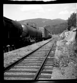
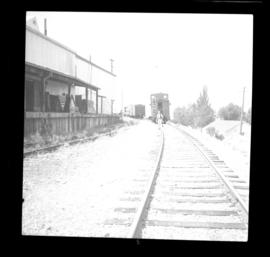
Photograph depicts the CPR line at Osoyoos at the BC Tree Fruits Ltd. warehouse and spur. This is about 1 mile north of the depot. The daily freight train from Penticton is returning from Osoyoos, having just collected 1 boxcar of fruit, backing onto caboose. This is approximately at mile 35.4 from Penticton.
Photograph depicts the CPR Kettle Valley Railway line just south of the Glenfir passing loop, on the Carmi Subdivision. Location is at about mile 118.5 from Midway. The photo shows a Penticton bound freight train at 1pm on a Tuesday, which consisted of 2 locies, 1 boxcar, 4 tank cars and a caboose. There are about 2 freights a week here. Glenfir is at 2572 ft. above sea level and 1450 ft. above Penticton.
Photograph depicts the CPR line at about mile 70 on the Carmi Subdivision, and 2 miles west of McCulloch depot. This is at the summit of the line at about 4150 ft. The whistle sign is a rarity as all the signs and telegraph posts were removed. Warning fro an old gravel pit not used for 20 or 30 years. The view is looking west.
Photograph depicts Myra depot on the CPR Kettle Valley line. The depot is at mile 83.8 and is only 8 miles from Kelowna but 2800 ft. above it. Trevor Davies, aged 8 3/4, is in the foreground.
Photograph depicts the CPR Kettle Valley Railway in Myra Canyon. The view is looking south into the canyon at about mile 85.
Photograph depicts "Princess Marguerite" at the CPR wharf in the Inner Harbour of Victoria.
Photograph depicts a "Master" tug after it underwent restoration in False Creek, Vancouver. It was under steam, and entering English Bay.
Photograph depicts a clamshell dredge at work near a BCE Railway trestle. Its spurs were down, suggesting rip-rap dumping.
Photograph depicts "Island Tug #125," on the north arm of the Fraser River. Travelling downstrean from Patulla Bridge, New Westminster, and the CNR Lulu Island rail bridge.
Photograph depicts the "Haida Chieftain" tug of the Kingcome Navagation Ltd. at their wharf in Vancouver.
Photograph depicts the "Island Chief" tug of the Island Tug and Barge Company, off pier A3 (CPR) in Vancouver.
Photograph taken on the north arm of the Fraser River. Looking southeast from Queensborough Bridge to the north end of Wood Street.
Photograph depicts a privately owned tug of the Interior Lake Services called "Iris G." It was used to haul rail barge #6 between Slocan and Rosebury on Lake Slocan. It was in 1956 in New Westminster.
Photograph depicts a vessel called the "Ocean traveller." It was backing off from a public pier in Ucluelet.
Photograph depicts a clamshell dredge at work beside a BCE Railway trestle. It appeared to be placing rip-rap.
Photograph depicts a CPR tug called the "Naramata." It was built in 1913 and sold out of service in 1970.
Photograph depicts a former sternwheeler building and repair slipway as well as a steam tug called the "Naramata." Steamer passengers ceased at the location in 1935 and rail service to the "Landing" in 1940.
Photograph depicts a replica of the "SS Beaver" built by the RCN in Esquimalt and moored in Vancouver, open to the public. Its pump handle that operated the capston, was reconstructed from a drawing done in 1870.
Photograph depicts a cannery at the seaward entrance to the south arm of the combined north arm of the Fraser river. Visible are a few rusted anchors. One was marked "Locomotive B.C. 100 Ibs. 1943 U.S. Navy."
Photograph depicts "H.R. Macmillan," a private yacht.
Photograph depicts the annual Bath-Tub Race that took place in Nanaimo. Visible is a competitor preparing for the start. There were 106 entries in that year.
Photograph depicts the "Canadian Princess" at permenant mooring as a restaurant, in Ucluelet.
Photograph depicts "Uchuck III" at its base in Gold River. It was operated by Nootka Sound Service, Ltd. It ran commercially to Zeballos and Tahsis. It also brought summer tourists to Friendly Cove, a historical site, as it held capacity for 100 passengers.
Photograph depicts a steam floating derrick (owned by Mckenzie Barge and Derrick Co. Ltd.) loading contariners from a scow into the hold of "Japan Line." Use of the crane on the non-deck side of a ship was unusual and the use a steam crane was quite exceptional, Davies notes.
Photograph depicts a Public Works Department vessel, "Essington II." It was fitted with a crane and used for snag removing, buoy work and light pile driving. Here, it was shown with the barge alongside it.
Photograph depicts "Fireboat" that was built for the Nanaimo-Vancouver Bath-Tub Race. The race had terminated at Fisherman's cove on the same day.
Photograph depicts one of the entries in the Nanaimo-Vancouver Bath Tub Race. Thre were 2112 entires and there was 32 mile crossing. Only 46 reached the finish line, of which this was one.
Photograph depicts the Hanceville Bridge that went over the Chilcotin River.
Photograph depicts the Lions Gate (suspension) Bridge.
Photograph depicts the Hazelton suspension bridge.
Photograph depicts the former bridge that crossed the Nanaimo River. Davies had taken a photograph of the bridge in June 1965, when it was in use. The bridge was superceded by a newer one a year prior the photograph was taken. On June 13, 1972, it was standing, but on this day the Highways Department took it down.
Photograph depicts a former highway bridge that was probably made obsolete when the new road to Edmonton was built in 1970.
Photograph depicts Cisco Bridge that spanned the Fraser River 36 miles below Lytton in Fraser Canyon. It was believed to be the origininal bridge that was built with under slung girders.
Photograph depicts Cisco Bridge that crossed the Fraser River 36 miles below Lytton in Fraser Canyon.
Photograph depicts a covered wooden grider bridge of the former Great Northern Railway spur that ran from north Washington state into B.C. at Keremeos, then west to Princeton. It was now only operating as far north as Keremeos.
Photograph depicts a CPR bridge over Pitt River.
Photo deoicts the lifting span of an existing rail bridge that was stuck in upwards position after the north pier had been struck by a freighter, putting the towers out of alignment. Visible is a crew working at the base of the north tower.
Photograph depicts three crossing at Second Narrows in Vancouver Harbour. On the left was a new CNR bridge being built. In the middle was exsiting CN track. To the right a high level road bridge is visible.
Photograph depicts a rail bridge crossing the Fraser River. Right-of-way suggested little usage, but tracks indicated a train had passed within the past 3 days since the photograph was captured.
Photograph depicts the Big Bar Creek ferry crossing over the Fraser River.
Photograph depicts a freight wagon that stood beside a deserted farm house.
Photograph depicts a reconstructed wagon at a Surrey gas station.
Photograph depicts an old wagon at a ranch on the east side of Peterson Creek.
Photograph depicts a lumber wagon.
Photograph depicts a little used works trailer of steam traction. Era vintage, but carried 1966 trailer plates.
Photograph depicts an early type of truck that was on display during a May Day Parade. It was owned by a service station operator on the Island Highway.
Photograph depicts a tank that was found outside of the headquarters of the British Columbia Armoured Regiment in Vancouver.
Photograph depicts a road roader at work doing black top patching and that belonged to the Pavements Department of the City of Vancouver. Built by Aveling Barford Ltd., Grantham, Lincs, England.
Photograph depicts a Goodyear Blimp cruising over the Centennial Museum near Sunest Beach, False Creek, Vancouver.
Photograph depicts air tanker fire base of the BC Forest Service. Manufactured by Conair Aviation Ltd.