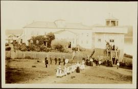
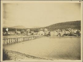
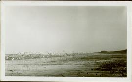
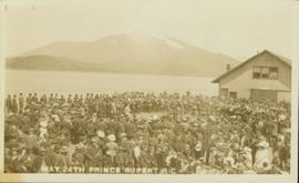
Photograph of large crowd spanning the frame of the photograph. A large marching band is visible along the edges of a small clearing in the centre. Annotation on recto reads: "May 24th Prince Rupert BC."
Photograph of a mountain on the waterfront. Annotation on recto reads: "Portland & Stewart. New Twin Cities. Portland Canal. June 17th 1910. Button Photo. Prince Rupert, BC."
Photo depicts a street perspective cars lining Third Avenue, in Prince George, BC, ca. 1950. Annotation recto reads: "3rd Ave Prince George BC Photo J. Wrathall." Handwritten annotation in pen on verso of postcard reads: “This is the equivalent of our Granville Street. Both theatres are located here as well as Hudson Bay Co., banks, library & stores.”
Photographic overview of the Eagle Lake Sawmill. Handwritten annotation in pen on verso reads: “The mill.”
Shoreline perspective of Eagle Lake. Handwritten annotation in pen on verso reads: “This is Eagle Lake. It is about 2 blks [sic] away.”
Street view side perspective photograph of several businesses in downtown Stewart, BC.
Elevated, wide angle photograph of Stewart, BC with mountains visible in the background.
Photograph taken from a low elevation of various businesses in Stewart, BC. Visible businesses include "The R. Boyd Young Co." and "Motel King Edward." Printed annotation on recto reads: "Cor. 5th and Columbia Sts. Stewart. B.C. Hughes #44."
Photograph of two horse driven carts driving past a house situated at the foot of a forested mountain.
Front view of two men sitting on a pile of supplies with a mountain in the background. Printed annotation on recto reads: "On the Divide Enroute to Naas #96."
Photo of a mountain with what appears to be Stewart, BC at its foot. Printed annotation on recto is partially obscured by fading and reads: "[Illegible] Stewart, BC."
Elevated photograph of two small houses surrounded by tall trees. A large mountain is visible in the background.
Photograph of the S.S. Prince George traveling through the water. Several mountains are visible in the background. Printed annotation on recto reads: "S.S. Prince George Enroute to Stewart, B.C."
Photograph of several men traveling across a river. Printed annotation on recto reads: "Fording The Nelson River Going to the Naas #93."
Photograph of a small creek traveling through several rocky embankments.
Photograph of a large group of people gathered around a steam engine loaded with coal situated on a wooden bridge. Printed annotation on recto reads: "Stewart BC Aug 9th 1911."
Street view photograph of two individuals watching the snow slide down one of the mountains surrounding Stewart, BC. Printed annotation on recto reads: "Snow Slide Stewart B.C. July 7/11."
Photograph is a printed postcard depicting a section of railroad track going through a mountain pass. Possibly near Stewart B.C.
Photograph depicts view of snow capped mountains with water in the foreground.
Photograph depicts view of falls with trees in background, possibly near Stewart B.C.
Photograph depicts view a panoramic view of Stewart B.C. taken from an elevated view.
Photograph depicts the sons and daughters of Marion and Archdeacon W.H. Collison sitting on the ground with food supplies at the top of a hill. Individuals believed to be (left to right): Arthur, Elsie, Herbert, Henry (in chef's hat), unknown, William, John Maxwell ('Max').
Handwritten annotation on verso reads: "Collison family on prospecting trip up Portland Canal."
Archdeacon William Henry Collison stands with cane in centre of group, trees and hills in background.
Handwritten annotation on verso reads: "Meadow - Kincolith / Uncle Don - Grandfather, Aunt Alice, Aunt Elsie / Uncle Max + cousins". Donald Macdonald married W.H. Collison's daughter Emily.
Rev. William Edwin Collison stands in centre of boat, with wife Bertha and daughters Muriel and Katherine seated behind. Unknown man and woman are also seated in boat, and an unknown man stands on shore holding rope.
Handwritten annotation on verso reads: "Will Collison with wife & children leaving Metlakatla to catch steamship en route to England (1910)".
River crosses midground, hills on distant shores can be seen in background.
Handwritten annotation on verso reads: "No. 32, First Beginning Prince Rupert, showing Church Hall, with cross. Insert Page 136".
Photograph depicts a group of children dressed in white walking in a line, and adults and other children watching from behind. Group of six man stand in line on left, one holding a flag, another a drum. Jail tower and large building stand behind fence in background.
Handwritten annotation on verso reads: "Old Mission House & jail at Metlakatla Before the fire."
Photograph depicts a group of men, women, and children walking across beach towards water. Buildings visible on shore in left background.
Handwritten annotation on verso reads: "Funeral party - en route to boat Metlakatla BC (Taking body over to Grave Island".
Handwritten annotation on verso reads: " '[Naskeena?' anchored off Metlakatla with Dr. [Mc-?] & Capt. Barry standing on its deck".
Unidentified man can be seen standing by small boat on shore in foreground, a second boat visible in water behind. Hills on opposite shore can be seen in background.
Handwritten annotation on verso reads: "Metlakathla B.C. 'Stern-wheeler' passing village."
Photograph depicts town buildings on opposite shore. Beach and dock can be seen in foreground.
Handwritten annotation on verso reads: "Chapter XXII, No 1. Eastern Section of Port Simpson as christianized."
Photograph depicts a flock of birds at beach, water and shoreline in background.
Handwritten annotation on verso reads: “North Beach Massett QCIs."
Forest and hills on opposite shore in background.
Boat floats close to shore in foreground, forest and hills on opposite shore in background. Joyce is the daughter of Bertha and W.E. Collison, and the granddaughter of Marion and Archdeacon W.H. Collison.
Handwritten annotation on verso reads: "Upper Nass River Sept. 1933. Joyce with Tom Moorhouse & the medical officer".
Handwritten annotation on verso reads: "Travelling thru' canyon on Nass River 'Engine & poles'".
Hill on opposite shore in background.
Three men can be seen carrying bundles across bridge above river, forest on shore in background.
Handwritten annotation on verso reads: "Upper Nass River. Chapt. XXII. No. 4. An Indian Bridge on a canyon."
Handwritten annotation on verso reads: "Lava plain Upper Nass River". Forest and hills visible in distance across plain.
Photograph depicts buildings on shore in background, hills visible in distance.
Handwritten annotation on verso reads: "1st canyon Nass River".
Handwritten annotation on verso reads: "Lower end of canyon on Naas River. North of Prince Rupert". Forest and mountains visible on shore in distance.
Photograph depicts community buildings on shoreline, water in foreground.
Handwritten annotation on image reads: "Wrangle, Alaska."; on verso: "Fort Wrangle, Alaska Territory. visited by W.H.Collison, C.M.S. 1877. Prior to the establishment of any mission, [...? illegible] 1875 - 1876. Presbyterian. Insert this illustration of Wrangle on Page 77 as marked."
Three Indigenous men stand in a canoe poling their craft along a shoreline while one man sits and steers. An unidentified village is visible along the opposite shore.
Rocky shoreline featuring a small dwelling, totem pole, net rack, canoes pulled up to shore, barrels and boxes and a tent.
Handwritten annotation in pencil on verso reads: “Kunhalas [sic] at entrance to C--- Harbour”.
Photograph depicts the El Dorado fishing boat off the coast of British Columbia, possibly near Haida Gwaii.
Photograph depicts an aerial view of the proposed site for the Fairview general cargo dock elevator site.
Photograph depicts workers sitting in the back of a truck at the construction site for the Pacific Northern Gas pipeline from Summit Lake to Kitimat.
Photograph depicts the proposed site for a hydro power project on Klemtu Lake with rock sill outlet to creek.
Photograph depicts two men beside the creek below the lake outlet at the proposed site for the hydro power project on Klemtu Lake.
Photograph depicts the view to the north from the terminal building at the Rainbow Lake Ski Club.
Photograph depicts a view of Friendly Cove, near Nootka, on the west coast of Vancouver Island. View is taken from the M.V. Uchuck III.
Photograph depicts Wickaninnish Beach, north of Ucluelet on Vancouver Island.
Photograph depicts fields recently cleared from virgin bush on Miracle Breach on Vancouver Island.