Print preview Close

Showing 4134 results

Archival description
3619 results with digital objects Show results with digital objects
2006.20.12.35 · Stuk · [ca. 1940]
Part of Northern BC Archives Historical Photograph Collection

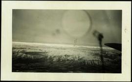
Handwritten photo album caption below this photo reads: "Above the Rockies at 12 000 feet." Photograph depicts the Rocky Mountains from a distance. As the photograph was taken from the inside of an airplane, the plane's wing tip can be seen on the far right of the image. A sun circle is also visible in the top center.

Zonder titel
Album No. 3
2009.10.3 · Bestanddeel · [between 1923 and 1926]
Part of Fred Jeffery Photograph Collection

Images within album consist primarily of fishery industry, river & landscapes, salmon cannery images (housing, people, workers, boats) on the Nass River and North Pacific Coast, ca.1924-1926. Each photograph is accompanied by a handwritten description glued below or beside the image.

Plane on Summit Lake, BC
2005.3.36 · Stuk · [ca. 1945]
Part of John Hart Highway Photograph Collection

Handwritten caption above this photo reads: "Plane on Sumit Lake." Logs can be seen floating on water in foreground, as well as trees on opposite shore in background. The seaplane has the letters "CF-ATF" on its side.

2004.6.22 · Stuk · [between 1920 and 1940]
Part of Stuart Lake Photograph Collection

Typed annotation on recto: "Fishing action - Stuart Lake, B.C." Two men fishing in a canoe, with one fish caught in net. Hillside in background. It is speculated that the seated man with fish may be Vivian Grey.

Maps
2000.23.1.070 · Bestanddeel · 1967-1989
Part of Audrey Smedley L'Heureux fonds

File consists of maps and pamphlets for British Columbia historic trails, waterways, historic towns, and geological features. Materials include newspaper clippings, placemats, pamphlets, and maps. Highlights include:

  • Parks Canada, "Fort Langley National Historic Park British Columbia", [198-?] (pamphlet)
  • North Pacific Cannery Village & Museum, "Discover British Columbia's Oldest Surviving Salmon Cannery Only 20 minutes from Prince Rupert", [198-?] (pamphlet)
  • Ministry of Lands, Parks and Housing, "Barkerville Provincial Historic Park", 1986 (pamphlet)
  • Map, "Yellowhead Highway 16 West Gateway to Alaska", [197-?]
  • Columbia River Projects, "Mica Dam", [197-?] (pamphlet)
  • Ministry of Lands, Parks and Housing, "Crooked River Provincial Park", 1980 (pamphlet)
  • Parks Canada, "Fort St. James National Historic Park", 1981 (pamphlet)
  • "Centennial Map of Canadian History and Achievements 1867-1967"
  • B.C. Hydro, "W.A.C Bennett Dam Peace River", 1971 (pamphlet)
  • Ministry of Lands, Parks and Housing, "Tweedsmuir Provincial Park (south)', 1984 (pamphlet)
  • McKenzies M7 Trails West, "Explore the Canadian Rockies", [198-?] (pamphlet)
  • Department of Lands, Forests, and Water Resources, "Coastal Systems", 1968 (map)
2002.12.29.1 · Stuk · c.1970-c.1989
Part of Bob Harkins fonds

Item consists of transcript and taped summary of recorded interview with long-time resident Ted Williams who discusses his father' Chuck Williams early years in Prince George c.1920s. He also discusses river transportation, steam boats on the Fraser River and river scowing adventures on the Grand Canyon (BC) and fatalities that occurred.

Zonder titel
2008.3.1.22.36 · Stuk · [ca. 1995]
Part of Bridget Moran fonds

Photograph depicts sign in foreground outlining rules and restrictions for behaviour at Moricetown Canyon. Traditional fishing territory visible behind sign at waterfall in the Bulkley River, B.C. Highway and buildings can be seen in background.

Main Street of Rolla
2000.19.2.2 · Stuk · 29 Aug. 1927-26 Sept. 1927
Part of Prentiss Gray Collection

Photograph depicts the main street of Rolla with a dirt street and wooden sidewalks, tethered horses, and the storefront of H.G. Atkinson General Merchants. Three people are visible walking through the streets.

2008.2.1.07 · Stuk · 1923
Part of Northern BC Cartographic Collection

Provincial map depicting communities, bodies of water, transport routes, land districts, parks, telegraph/telephone lines, and mining regions, offices, and engineers. Includes Distance Tables (“Coast,” “Roads,” “Railways,” and “World”) and Index of Post Offices.

Northern British Columbia
2008.2.1.18 · Stuk · 1 May 1933
Part of Northern BC Cartographic Collection

Regional map depicting communities, parks, customs posts, airports, radio stations, hatcheries, bodies of water, transport routes, communication lines, elevation points, and lines of batholith contacts. Includes an inset of St. Elias Mountains. Includes “Special Note on the Mineralization of this Map Area” from Bureau of Mines, Victoria, B.C.

2009.7.1.249 · Stuk · ca. 1880-1920
Part of Archdeacon W. H. Collison fonds

Large crowd is gathered around main building in a harbor. Many boats visible in foreground. Smoke from tugboat partially obscures the scene. Annotation on recto reads: "Prince Rupert BC. Photo by MCrae Bros."

SS Camosun at Prince Rupert
2009.7.1.272 · Stuk · ca. 23 May 1909
Part of Archdeacon W. H. Collison fonds

Photograph of the SS Camosun arriving in a harbour in Prince Rupert. A blurry man is in the lower right corner of the foreground. Another large vessel can be seen behind the Camosun. Annotation on recto reads: "SS 'Camosun' at Prince Rupert Allen Photo May 23[?]09."

2009.7.1.273 · Stuk · [ca. 1880-1920]
Part of Archdeacon W. H. Collison fonds

Photograph of a small vessel on the ocean with a dock and harbour buildings in the foreground. Tents and piles of lumber can be seen among the buildings. Annotation on recto reads: "The Wharf, Prince Rupert, BC. 1657." Printed annotation on verso reads "The Wharf, Prince Rupert, BC J. Howard A. Chapman, Victoria. BC. 1657."

2009.7.1.277 · Stuk · [ca. 1880-1920]
Part of Archdeacon W. H. Collison fonds

Wide angle photograph of many buildings scattered in a clear cut area. Foreground shows several businesses, including "Kelly Carruther's Supply" and "Prince Rupert Hardware and Supply Co." Some remaining forest is visible in the background. Annotation on recto reads: "Prince Rupert, BC 1659."

2009.7.1.296 · Stuk · 20 October 1907
Part of Archdeacon W. H. Collison fonds

Photograph of several buildings down the street in Prince Rupert, including the church. Lumber pallets are littered around the buildings. Annotation on recto reads: "Prince Rupert, BC. 20.10.07."

2011.12.03 · Stuk · ca. 1950
Part of Giscome, BC Historical Photograph collection

Photo depicts a street perspective cars lining Third Avenue, in Prince George, BC, ca. 1950. Annotation recto reads: "3rd Ave Prince George BC Photo J. Wrathall." Handwritten annotation in pen on verso of postcard reads: “This is the equivalent of our Granville Street. Both theatres are located here as well as Hudson Bay Co., banks, library & stores.”

2011.13.08 · Stuk · ca.1910-ca.1930
Part of Parker photograph collection

Photograph taken from a low elevation of various businesses in Stewart, BC. Visible businesses include "The R. Boyd Young Co." and "Motel King Edward." Printed annotation on recto reads: "Cor. 5th and Columbia Sts. Stewart. B.C. Hughes #44."

Mountain behind Stewart, BC
2011.13.22 · Stuk · ca.1910-ca.1930
Part of Parker photograph collection

Photo of a mountain with what appears to be Stewart, BC at its foot. Printed annotation on recto is partially obscured by fading and reads: "[Illegible] Stewart, BC."