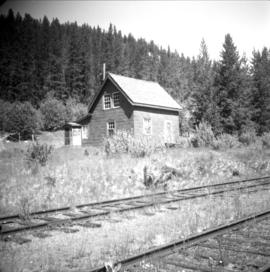
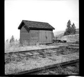
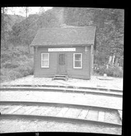
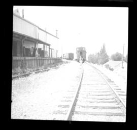
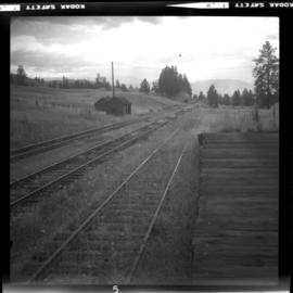
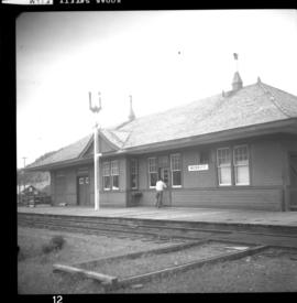
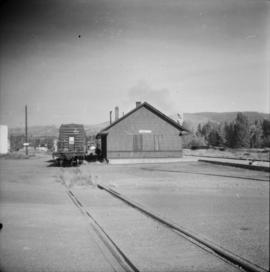
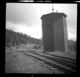
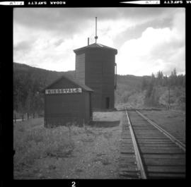
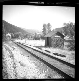
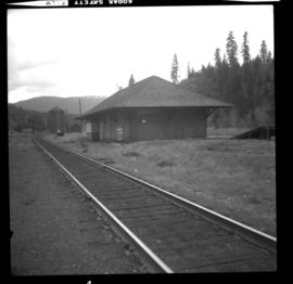
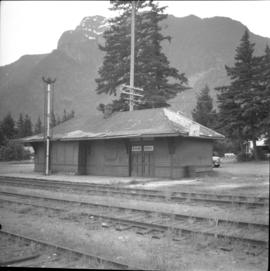
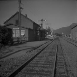
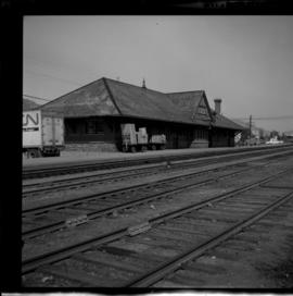
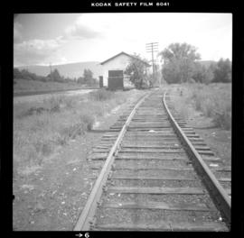
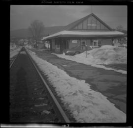
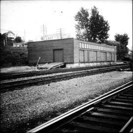
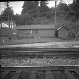
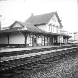
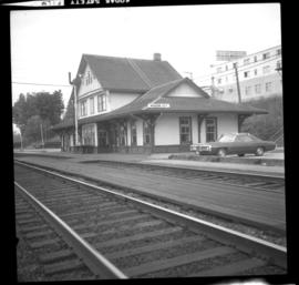
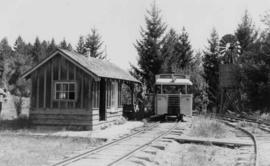
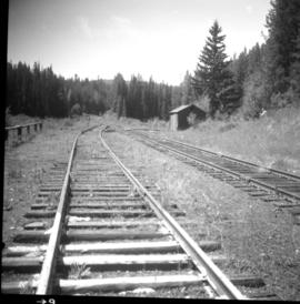
Photograph depicts the CPR depot at Chute Lake, on the Carmi Subdivision. It is located at mile 106.5 and 13.5 miles north of Penticton. The photo shows the passing track and the base of a former water tower is just behind the camera at the left. The rail here is dated 1942.
Photograph depicts the Chute depot at mile 106.5 on the CPR line in the Carmi Subdivision. It is a totally isolated location, but not reachable by road. The photo shows the only surviving large building. The rail here is dated 1942.
Photograph depicts the CPR line at Arawana, 5 miles northeast of Penticton. It was formerly a depot and water stop, then a passing loop and spur, and now nothing. The building in the photo is a typical track trolley shanty.
Photograph depicts the CPR line at Arawana, 5 miles northeast of Penticton and at mile 125.7 on the Carmi Subdivision. The photo shows the ruins of the station house and Okanagan Lake in the background. The passing loop in the foreground has been disconnected and partially dismantled. The rear track was used once or twice weekly by the way freight train between Penticton and Midway. The view is looking west.
Photograph depicts the CPR depot at Okanagan Falls, located at mile 10.6 from Penticton. The depot is locked and unused but it used to be the southern terminus of Skaha Lake when the line first opened in 1922. When the route along the edge of Skaha Lake was built, the Okanagan lost its barge and car slips in 1931. There is also a water pump at the right of the depot.
Photograph depicts the CPR line at Osoyoos at the BC Tree Fruits Ltd. warehouse and spur. This is about 1 mile north of the depot. The daily freight train from Penticton is returning from Osoyoos, having just collected 1 boxcar of fruit, backing onto caboose. This is approximately at mile 35.4 from Penticton.
Photograph depicts the CPR Osoyoos station and the arrival of the daily (except Sunday) way freight train from Penticton. The depot is at about mile 36.1.
Photograph depicts the CPR Kettle Valley Railway line at Osprey Lake, approximately 38.8 miles from Penticton, at the summit between Penticton and Princeton. The passing line was removed between 1956 and 1966. A small spur holding 5 cars remains and it was used to store a heavy crane to replace bridge members. The elevation at this point is 3, 606 ft.
Photograph depicts the CPR Faulder depot on the Kettle Valley Railway. It is located at mile 15.5 from Penticton, on the Princeton Subdivision.
Photograph depicts the Penticton CPR depot. The view is looking northwest.
Photograph depicts the CPR rail Belfort depot passing point, approximately 5 miles north of Princeton, on the Princeton to Penticton line. The view is looking south.
Photograph depicts the disused CPR Kettle Valley Railway line in Penticton. The trackage leads from the lakefront to the main yards. All the track was removed by July 1981. The view is looking northeast to the lake and the Incola Hotel.
Photograph depicts the West Summerland CPR station in the Okanagan. The station often was used but not permanently manned. It was located at mile 9.5 from Penticton. The view is looking south.
Photograph depicts the CPR depot at Merritt. When the Spences Bridge to Merritt branch line was first built its principal traffic was coal taken from the mines on the south edge of the city. As late as 1923 Middlesborough Mine produced 75,862 tons/year.
Photograph depicts the CPR Princeton depot. The view is looking east.
Photograph depicts the CPR line at Kingsvale, at mile 120.2 on the Princeton Subdivision between Brookmere and Merritt. It has a loop for 19 cars and sees one freight a day on Tuesday and Thursday.
Photograph depicts the CPR line at Kingsvale, at mile 120.2 on the Princeton Subdivision between Brookmere and Merritt. It has a loop for 19 cars and sees one freight a day on Tuesday and Thursday. The view is looking north.
Photograph depicts the CPR line at Coalmont, BC, located about 12 miles north of Princeton and at mile 82.2 from Penticton. Close by was the former Blakeburn Coal Mine, which operated until 1940. The view is looking south.
Photograph depicts an abandoned water tower on CPR line at Brookmere, 30 miles south of Merritt. The trackage on the right has had the spikes removed but the yard consists of a mixture of completely removed, partially removed, and completely undisturbed track. An elderly couple and 2 elderly bachelors are the only year-round remaining inhabitants.
Photograph depicts the CPR line at Brookmere, 30 miles south of Merritt (now mile 108.7 on the Princeton Subdivision). Summit point is at 3200 ft. between Spences Bridge, Hope, and Princeton. The Kettle Valley Railway carved out a railway town in the wilderness in 1914/1915 to hold about 300 people. The men were train crews and track a gangs, particularly for the troublesome Coquihalla route. The photo includes the boarded up depot and the view is looking north.
Photograph depicts the interior of a snow shed at about mile 29.0 using CPR mileages commencing at Brookmere, which is 4 miles east of Brookmere. It is on the ex CPR Coquihalla Line from Hope to Brodie Junction.
Photograph depicts the derelict CPR depot at Hope, part of the former Kettle Valley line. A spur of about 3 miles still exists between the Odlum junction with the main line on the north side of the Fraser River and this depot, and continues southeast to a point near the CNR. It is not abandoned, but little used. The Hope yard has a 47 car capacity.
Photograph depicts the CPR depot at Armstrong. It is located about mile 32 from Sicamous on the Okanagan Subdivision. The view is looking south.
Photograph depicts the joint CPR and CN depot at Vernon. The depot office had three employees working inside. Vernon is at mile 46.2 from Sicamous, on the Okanagan Subdivision of the CPR. It has daily way freight.
Photograph depicts the Mission City rail and road bridge. It is owned by the CPR and was opened in 1891. It was used by road vehicles between 1 July 1927 and the 23 June 1973, using a one way flow system. On the latter day, a new high level road bridge was unofficially opened. By early July 1973, the CPR had removed the wooden deck planking.
Photograph depicts the CPR Mission Bridge on the Huntingdon branch. The swing span is in an open position and the view is looking west and downstream. A new road bridge to be opened within the month is in the background. The bridge cabin holds a gas engine that turns the span in about 60 seconds.
Photograph depicts the CPR Mission Bridge on the Huntingdon branch. The span opened to allow downstream passage of a tug and derrick, which passed at about 6 to 8 knots because of the freshet. Tow started at federal wharf at Mission City. The span opens for river traffic every 2 or 3 days. The view is looking east and upstream.
Photograph depicts the CPR Mission Bride on the Huntingdon branch. The photo was taken from the open swing, and shows a tug and derrick passing swiftly downstream in the north channel of the opening. The span opens about every 2 or 3 days for river traffic.
Photograph depicts the CPR Mission Bridge on the Huntingdon Branch. It shows the final box span of the bridge on the south shore, as viewed from the opened swing span. The span opened for river traffic every 2 or 3 days. The view is looking south, with downstream to the right.
Photograph depicts the CPR Mission Bridge on the Huntingdon branch. The photo was taken from the open swing span looking downstream, with a tug and derrick (Fraser River Pile Driving Co.) fast disappearing downstream. The new road bridge in the background is about to be opened in late June 1973.
Photograph depicts the CPR at the Huntingdon/Sumas border (BC/Washington State border). A Mission way freight train is standing at about 5 pm, ready to return to Mission. The photo shows CP caboose #436733, built in 1920 out of wood. The border is about 10 ft. behind the camera.
Photograph depicts the CPR Mission Bridge on the Huntingdon Branch. It shows the daily southbound way freight train at about 12:30 hours STD time, crossing the bridge. The train consisted of two locomotives, about 35 cars, and a 1920 wooden caboose. The lead locomotive was CPR 8510, GM class 0-4-4-0, built in 1954. There is a 10 mph speed restriction on the bridge.
Photograph depicts the CPR Mission Bridge on the Huntingdon Branch. The view is looking north from the open swing span. The bridge is about 1700 ft. long and consists of eight 160 ft. tress spans, one 230 ft. swing span, and 3 girder spans. Seven of the eight truss spans are seen in this view, with the Fraser River in freshet.
Photograph depicts the CPR line at Notch Hill in the Shuswap. At one time this was a busy place, as helper engines were stationed here to push heavy trains over the hill. This spur is on the north side of the depot and has rails from 1902. The view is looking west, depicting the mainline to the left and just in view.
Photograph depicts an outhouse on Notch Hill in the Shuswap. Helper locomotives were stationed here to lift heavy trains over Notch Hill. It was presumably used by waiting engine crews.
Photograph depicts the CPR depot at Salmon Arm. It is occupied and in use. The view is looking east.
Photograph depicts the CPR depot at Chase, which is no longer in use.
Photograph depicts a CPR storehouse at Mission City. It was marked as "Petroleum Store" but in fact was holding speeders and miscellaneous track equipment. It was sited on the north side of the track at the extreme east end of the depot platform.
Photograph depicts a freight shed located on the north side of the rail line and some 200 yards west of the Mission City CPR depot.
Photograph depicts small buildings sited on the north side of the tracks and just west of the Mission City CPR depot. They are all in use and well cared for.
Photograph depicts the Mission City CPR depot located at mile 87.3 from North Bend in Cascade Substation. It was built in 1902 and add onto in 1909. It has living quarters on the 2nd floor that are still in use, which is quite rare for BC in 1973. It is 41.7 miles from Vancouver and 2, 839.6 miles from Montreal.
Photograph depicts the Mission City CPR depot located at mile 87.3 from North Bend in Cascade Substation. It was built in 1902 and add onto in 1909. It has living quarters on the 2nd floor that are still in use, which is quite rare for BC in 1973.
Photograph depicts a railcar and possible shed or depot. Location and details unknown.
Photograph depicts a derelict locomotive shed at Union Bay on Vancouver Island. It is a Canadian Colliery Resources Ltd. shed, last used 15 Aug. 1960. Operations finished that day and disposal of all the equipment followed.
Photograph depicts the Great Northern Railway depot at Keremeos and the terminus of the line from Wenatchee, Washington, U.S.A. The line stops about 1/3 mile beyond this point. At one time it ran on to Hedley mine and possibly Princeton.
Photograph depicts the Great Northern Railway former station at Cascade, just north of the Canada-U.S. border and 15 miles east of Grand Forks. The line connects Kettle Falls and Grand Forks, but the station is now disused but in good repair. The view is looking south towards Washington State.
Photograph depicts the Sumas depot of the Northern Pacific Railway in the U.S. The Canadian border is at the grade crossing in the middle distance.
Photograph depicts the rear of the Great Northern depot on Main St. in Vancouver, that is now demolished.
Photograph depicts a partially demolished Great Northern Railway depot and Canadian National Railway (CN) depot behind it, in Vancouver.
Photograph depicts the demolition of a Great Northern Railway depot in Vancouver.