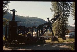
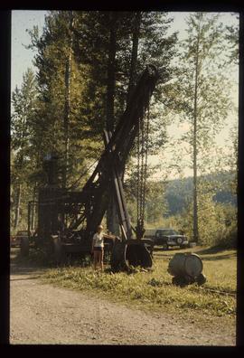
Print preview Close

Showing 956 results

Archival description
956 results with digital objects Show results with digital objects
Steam Shovel
2012.13.1.69.22 · Stuk · [1981?]
Part of J. Kent Sedgwick fonds

Image depicts a woman standing next to a steam shovel, located in Quesnelle Forks.

A Saw
2012.13.1.87.036 · Stuk · [between 1975 and 1995]
Part of J. Kent Sedgwick fonds

Image depicts a saw and numerous wooden boards at an uncertain location.

Logs and Machinery
2012.13.1.87.056 · Stuk · [between 1975 and 1995]
Part of J. Kent Sedgwick fonds

Image depicts numerous piles of logs, and two unidentified individuals operating an excavator with a "thumb" attachment during the demolition of the Upper Fraser town site. Map coordinates 54°06'51.6"N 121°56'26.3"W

2012.13.1.93.29 · Stuk · 1978
Part of J. Kent Sedgwick fonds

Image depicts numerous pieces of what appears to be old farming equipment. There is also an unidentified individual sitting aginst the side of a building. The location is possibly Fort St. John, B.C.

Inside Machinery
2012.13.1.93.50 · Stuk · 1978
Part of J. Kent Sedgwick fonds

Image depicts two individuals at work inside what appears to be a piece of machinery. It is possibly located somewhere in Fort St. John, B.C.

Large Metal Cylinder
2012.13.1.93.51 · Stuk · 1978
Part of J. Kent Sedgwick fonds

Image depicts a piece of machinery shaped like a large metal cylinder. It is possibly located somewhere in Fort St. John, B.C.

Computer Room?
2012.13.1.93.52 · Stuk · 1978
Part of J. Kent Sedgwick fonds

Image depicts what appears to be a computer room at an uncertain location, possibly in Fort St. John, B.C.

2012.13.1.121.07 · Stuk · July 1970
Part of J. Kent Sedgwick fonds

Image depicts an atmometer. According to the slide, it is being used for measuring the rate of water evaporation "from carborundum stone." The location is uncertain.

Cypress Hill?
2012.13.1.121.09 · Stuk · July 1970
Part of J. Kent Sedgwick fonds

Image depicts two unidentified individuals and a van on a farm at an uncertain location, possibly a place called Cypress Hill, with an atmometer and a sunshine recorder.

Evaporation Pan
2012.13.1.121.10 · Stuk · July 1970
Part of J. Kent Sedgwick fonds

Image depicts an evaporation pan for water evaporation measurements. The location is uncertain.

Dr. Joselito Arocena fonds
2016.7 · Archief · 1988-2019

Fonds consists of the research and professorial records of Dr. Joselito Arocena, a founding faculty member of UNBC. Arocena was an internationally-recognized soil scientist and UNBC’s first Canada Research Chair. His records demonstrate his accomplishments as an academic and researcher, as well as his many and varied interdisciplinary research endeavours. Also included are selections from Arocena’s extensive photographic slide collection which illustrate his teaching, research projects, and personal interests.

Zonder titel