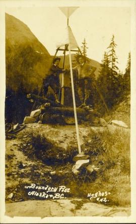
Photograph of two men posing next to a four-legged post erected in the wilderness. Printed annotation on recto reads: "Boundery[sic] Post Alaska & BC. Hughes #42."
Front view of a stretch of railroad passing through a forested area. Photograph shows a mountain in the background.
Photograph of a large glacier with several buildings at its foot. Printed annotation on recto reads: "Hughes #76 Glacier Near Stewart BC."
Photograph of a stretch of railroad passing by a small body of water. Mountains are visible in the background.
Photograph of a train passing through a forested area.
Photograph of a train passing over a bridge near Stewart, BC. Printed annotation on recto reads: "103 Stewart BC."
Photograph of several log buildings in a forested area at Red Cliff mine. Printed annotation on recto reads: "Red Cliff Buildings Hughes 86."
Photograph of several log buildings and mining equipment in winter. Printer annotation on recto is mirrored and reads: "At The Red Cliff Red Cliff."
Ground level photograph of a forested slope, with large glaciers visible in the background. Printed annotation on recto reads: "Glacier Near Stewart B.C. Hughes #75 [or 15??]"
Photograph is a printed postcard depicting a few cabins covered in snow near Stewart B.C.
Photograph depicts view a panoramic view of Stewart B.C taken from the valley bottom.
Photograph depicts a panoramic view of Stewart B.C. Annotation on front "Bird's Eye View" "Stewart, BC"
Photograph depicts Henry Alexander, son of Marion and Archdeacon W.H. Collison, leaning on walking stick on top of rocky hill. Mountains in background.
Handwritten annotation on verso reads: "Henry Collison on prospecting trip. Portland Canal."
Photograph depicts two young granddaughters of Marion and W.H. Colllison, holding flowers in grassy area. Forest and hills in background.
Handwritten annotation on verso reads: "Winnie & Joyce at Kincolith". Marion Winnifred is the daughter of John Maxwell Collison, and Joyce is the daughter of William Edwin Collison.
Joyce stands knee-deep in water, holding a long wrapped object, with a bundle resting on her shoulder (daughter of Archdeacon W.H. Collison's eldest son William Edwin). Trees and bushes visible on opposite shore in background.
Handwritten annotation on verso reads: "Joyce circa 1937 at Kincolith".
Photograph depicts a large ship behind dock buildings. Railroad crosses foreground, hills visible on shore in background.
Handwritten annotation on verso reads: "Drydock Prince Rupert".
Photograph depicts buildings visible through clearing in trees. Water crosses foreground, hills visible in background.
Handwritten annotation on verso reads: "Dry dock / Prince Rupert B.C."
Handwritten annotations read: "At rest, after a rough passage of two days and a night from Massett, Queen Charlotte's Islands by canoe - W.H. Collison and Mrs. Collison with Indians from Masset"; "Archdeacon Collison Indian Canoe & Crew. Return from Queen Charlotte's Islands, Haida & Tsimshian Crew [...?]" Archdeacon and Mrs. Collison sit in centre of canoe.
Totem poles (crest poles?) stand in front of remains of wood structures built along sandy shore. View from above, forest on hill in background.
Handwritten annotation on verso reads: "[? illegible] Deserted village West Coast QCIs."
Photograph depicts narrow valley between steep cliffs.
Handwritten annotation on verso reads: "on left Vertical side of old Indian fort at Nagas W. Coast Q.C.I".
Photograph depicts totem poles (crest poles?) in front of lodge buildings on river shore. Canoes can be seen floating in foreground, hills in background.
Handwritten annotation on verso reads: "Chapter XII. Number 1. Section of Indian Village on Nass River showing lodges and totems".
Village can be seen in distance. Large church building stands in centre, hills in background.
Handwritten annotation on verso reads: "For heading of Page 18. Kincolith or 'The Rock of Scalps.' Section of Kincolith [...]"
Forest and hills on opposite shore in background.
Handwritten annotation on verso reads: "poling canoe up Nass River".
Handwritten annotation on verso reads: "Nass River canyon at flood water". A building is visible on shore in distance, and mountains can be seen in background.
Photograph features a steep cliff across still water.
Handwritten annotation on verso reads: "Place of Scalps / Kincolith BC"
Totem poles (crest poles?) stand in front of wooden houses on right. Hills on shoreline visible in background.
Handwritten annotations on verso read: "West Coast QCIs."; "[Old?] Kassan Alaska."
Carvings visible on a moss covered rocky outcrop. Handwritten annotation in pencil on verso reads: “Rock carvings. Copper Mountain, Al”.
Photograph depicts a westward view from the terminal building at the Rainbow Lake Ski Club.
Image depicts numerous old buildings on a main street in Atlin, B.C.
Image depicts what is possibly Atlin Lake, with numerous mountains in the distance and Atlin Mountain visible on the right of the image.
Image depicts a river in the Miles Canyon near Whitehorse Y.T.
Image depicts a river in the Miles Canyon near Whitehorse Y.T. The Robert Lowe Bridge, built in 1922, can be seen over the canyon.
Image depicts a lake and a cabin at an uncertain location.
Image depicts a bear, possibly a grizzly. The location is uncertain.
Image depicts two merging railway tracks, and what appears to be a frozen river, somewhere near the summit of a mountain.
Image depicts a view over a forested, mountainous area and a river towards the vicinity of Skagway, Alaska.
Image depicts a grave somewhere along the White Pass railway.
Image depicts the cableway in Willow River, B.C.
Image depicts a Beehive Burner along the Nechako on River Road. Map coordinates 53°55'34.1"N 122°44'58.0"W
Image depicts a logging area somewhere near Prince George, B.C.
Image depicts a saw cutting a log in half at a saw mill in Prince George, B.C.
Image depicts a piece of heavy machinery lifting numerous logs off the back of a logging truck. It is likely located in Prince George, B.C.
Image depicts a small slope on Carney Hill in Prince George, B.C.
Image depicts an aerial view of a grooved region of land at an uncertain location.
Image depicts an example of varves, an annual layer of sediment or rock, with a pipe used for reference size. It is possibly located at the airport in Prince George, B.C.
Image depicts sand beds with a shovel present for size reference. The slide places it at the "BCR site," possibly in Prince George, B.C.
Image depicts grooving on Tabor Mountain in Prince George, B.C.