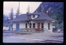
Print preview Close

Showing 432 results

Archival description
352 results with digital objects Show results with digital objects
River Ferry
2012.13.1.66.01 · Item · June 1987
Part of J. Kent Sedgwick fonds

Image depicts a ferry on a river, possibly the Fraser River in the Lillooet area.

A Camper
2012.13.1.65.83 · Item · May 1984
Part of J. Kent Sedgwick fonds

Image depicts a camper and a man and woman at an uncertain location, possibly somewhere near Meldrum Creek, B.C. The woman in the image is Sue Sedgwick.

Two Campers
2012.13.1.65.82 · Item · May 1984
Part of J. Kent Sedgwick fonds

Image depicts two campers at an uncertain location, possibly somewhere near Meldrum Creek, B.C.

Two Campers
2012.13.1.65.81 · Item · May 1984
Part of J. Kent Sedgwick fonds

Image depicts two campers at an uncertain location, possibly somewhere near Meldrum Creek, B.C.

Two Vans
2012.13.1.65.30 · Item · May 1975
Part of J. Kent Sedgwick fonds

Image depicts the hiking group packing their gear into two vans.

Helicopter and Man
2012.13.1.63.05 · Item · Aug 1989
Part of J. Kent Sedgwick fonds

Image depicts a man standing in front of a helicopter; a waterfall is visible on the cliffs in the background. The slide itself is labelled "BC Parks Tour."

Leo Creek - Office Building?
2012.13.1.62.22 · Item · June 1978
Part of J. Kent Sedgwick fonds

Image depicts a building, possibly an office building, next to a set of rail road tracks in Leo Creek, B.C. An unknown individual is present, and a number of barrels and culverts are visible in the foreground.

Trip Preparation
2012.13.1.60.01 · Item · July 1973
Part of J. Kent Sedgwick fonds

Image depicts a group of people preparing to depart on a trip. Location is uncertain, though it is possibly in Prince George, B.C.

Giscome Station
2012.13.1.6.034 · Item · May 1975
Part of J. Kent Sedgwick fonds

Image depicts the old Giscome Train Station in Giscome, B.C. It was demolished between 1976 and 1977.

Cariboo Road
2012.13.1.6.031 · Item · June 1974
Part of J. Kent Sedgwick fonds

Image depicts the Cariboo Road at Hat Creek Ranch, near Highway 99 on the way to Lillooet.

Cliff Road - Overhang
2012.13.1.59.14 · Item · July 1980
Part of J. Kent Sedgwick fonds

Image depicts a camper passing under an overhang as it drives along a narrow road near a cliff; located somewhere near Bralorne, B.C.

Cliff Road
2012.13.1.59.12 · Item · July 1980
Part of J. Kent Sedgwick fonds

Image depicts a camper parked on the side of a narrow road along a cliff as another car approaches; located somewhere near Bralorne, B.C.

Hat Creek Ranch - Road
2012.13.1.58.12 · Item · June 1987
Part of J. Kent Sedgwick fonds

Image depicts the road leading to the historic Hat Creek Ranch site north of Ashcroft, B.C. Several individuals are sitting on the front porch of the Ranch house.

Britannia Mine Entrance?
2012.13.1.54.52 · Item · July 1980
Part of J. Kent Sedgwick fonds

Image depicts the entrance to a mine with an unknown individual present. It is possibly the entrance to the closed Britannia Mine in the Howe Sound Region.

Train
2012.13.1.54.51 · Item · July 1980
Part of J. Kent Sedgwick fonds

Image depicts a train in an uncertain location.

Train
2012.13.1.54.50 · Item · July 1980
Part of J. Kent Sedgwick fonds

Image depicts a train in an uncertain location, though it is possibly Howe Sound in the background.

Dog Creek
2012.13.1.52.57 · Item · [1980?]
Part of J. Kent Sedgwick fonds

Image depicts a house and numerous rundown vehicles in Dog Creek, B.C.