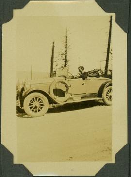
Item is a photograph of A.H. Phipps driving his convertible car.
Item is a photograph of Al Phipps kneeling on the ground and holding up the head of a dead black bear.
Item is a photograph of Al Phipps looking through the surveying equipment.
Caption: "It must have been a Sunday!"
Caption: "Paradise for man & beast. Timber-line"
Caption: "A river station"
Caption: "Another River station"
Caption: "Excelsior or Pilgrim with his load"
Item is a photograph of Al Phipps with a back pack on his back, standing with two pack dogs in the snow.
Item is a photograph of Al Phipps, Jack Anderson and Jack Adams beside a surveying station overlooking the Ingenika River.
File contains correspondence to Brian Fawcett from Al Purdy. Includes a letters to Brian Fawcett from Al Purdy, writer.
Item is an audio recording of Al Purdy.
Item is an audio recording of Al Purdy: Canadian Poets on Tape.
Item is an audio recording of Al Purdy reading at CNC.
Collection contains a signed Spruce Kings hat, a signed game puck and a letter to Al Lefebvre of UNBC.
File contains correspondence from writer, Alan Barber to Brian Fawcett.
File contains correspondence to Brian Fawcett from Alan Cassels, Lt. (N) Naval Section of Koh Kong, Cambodia. Includes a letter congratulating Brian on his book, "Cambodia", and Cassels expresses his thoughts and feelings in relation to the book. Letter dated August 10, 1993.
File contains correspondence from Brian Fawcett to Alan Copper.
File contains letters to Brian Fawcett from Alan Gasser. Correspondence includes poetry typed written by Alan Gasser. The items are dated August 1, 1989 and March 12, 1990.
File contains correspondence to Brian Fawcett from Alan Hoover, Assistant Anthropologist , Department of Recreation and Conservation, British Columbia Provincial Museum. Includes letters dated February 10, and March 25, 1969.
Photograph depicts Alan Safarik and Brian Fawcett at Fort San Saskatchewan.
File contains correspondence to Brian Fawcett from Alan Twigg. Includes letters to Brian Fawcett from Alan Twigg, Publisher of BC Book World regarding Brian's manuscripts. Letter predominately written 1989 to 1994.
File contains correspondence to Brian Fawcett from Alan Winter. Includes a letter to Brian Fawcett from Alan Winter, thanking Brian for review of his book. Letter dated June 25, 1988.
File contents relate to: Accounting / Payroll. Document type(s) include: delivery receipts.
Image depicts the ferry to Alaska in the port of Prince Rupert, B.C.
Image depicts a small section of the Alaska Highway somewhere near Whitehorse, Y.T. The slide also appears to be labelled "army washing" for unknown reasons.
File consists of documents relating to the Alaska Highway conference in 1992.
File consists of documents relating to the Alaska Highway Commemorative Symposium.
B.C.-Yukon-Alaska Highway Commission – Map showing Highway Routes to Accompany Preliminary Report on Proposed Highway to Alaska
? January 1940
? Legend includes: 1) Existing Main Highways, 2) Roads in Northern Area, 3) Routes Under Construction.
Photograph album contains 134 snapshots showcasing building activity, equipment, logging, and airplanes in British Columbia and the Yukon, taken during the building of the Alaska Highway in 1942. The photographer is unknown. Many of the photographs depict Fort St. John and Fort Nelson.
Some of the photographs are captioned as follows:
- Looking north at Fort St. John, B.C.
- P.R.A. Bellanea and Army Norseman sea-planes on Charley Lake near Fort St. John, B.C.
- Looking toward outlet of Muncho Lake from Float Plane
- Fort St. John, British Columbia. Canada
- Colonel Ingalls’ bridge across Liard River
- Post Office & Government Telegraph Office
- P.R.A. Camps at Fort St. John, B.C. looking N.E.
- Post Office & Government Telegraph Office - Fort St. John - 1942
- Army Ferry on Peace River near Taylor's Flats
- Looking west on Main Street, Fort St. John, B.C. May - 1942
- Looking southwest across Summit Lake
- Public Roads Administration Headquarters Buildings. Fort St. John, B.C. - April - 1942
- Looking southwest from south bank of Peace River from Old Highway near Taylor Flats, B.C.
- First Army Headquarters - Fort St. John, B.C. - 1942
- Beginnings of Fort Alcan - May 1942 - Fort St. John, B.C.
- Road between 101 and 157
- Other side Muncho Lake
- Big Black Bear
- Liard River, Canada
- Dog Sled. Muskwa River
- Temporary Bridge at Muskwa, B.C.
- Another bridge in British Columbia
- Above Fort Nelson, B.C. White spot in picture is the “moon”
- Mountains N-106
- Coughlin’s equipment at work west of Fort Nelson - Nov. - 1942
- Near Mile Post 175-N descending to shore of Muncho Lake
- First Fairbanks sign erected in Fort St. John. Apr. 1942
- Boat used to cross the Fort Nelson River at Fort Nelson
- Typical P.R.A. Engineers Camp at Mile 84-N
- Fort Alcan - near St. John. British Columbia. “1942.”
- Captain Hinze and Army beachcraft used on Army reconnaissance surveys for Alaska Highway
- Small single motored aircraft used by P.R.A. on Alaska Highway Reconnaissance flights forced down on Gravel Bar on the Laird [sic] River near Mile 313-N
- Near Mile 173-N looking at outlet of Muncho Lake
- Near Mile 145 N. Toad River looking downstream
- Looking southwest at Muncho Lake at Army operations on shore Pioneer Road. First tote road may be seen above.
- Hudson Bay Store at Dease Lake, end of truck portage from Telegraph Creek + Wrangell. Beginning of boat freighting to lower port
- Mile 104 n. Sugarfoot Lake
- Mile 104 N. Sugarfoot Lake
- Looking north from Mile 140 N. at Folding Mountains - approx. 8,000 ft high
- Army forces along Muncho Lake
- Malamute sled dog at Fort Nelson
- P.R.A. location. Engineers’ Camp near Mile 165-N
- Few miles west of Ft. St. John looking downstream at Peace River. Old Fort St. John. Buildings on near shore
- British Columbia Police Plane in Fort Nelson River at Fort Nelson, B.C.
- Few miles west of Fort St. John - Looking across Toad River at Little Folded Mountain near Mile 141
- Looking northwest at P.R.A. an Oakes Camp and Alcan Highway.
- Clouds after a rainstorm over Teslin Lake, Yukon Territory between Watson Lake and Whitehorse.
- Toad River and Big Folded Mountain near Mile 142 N
- Teslin Lake between Watson Lake & Whitehorse Y.K. The lake is 72 miles long
- Whitehorse, Yukon Territory
- Dept. of Transport Ferry on Peace River near Taylor Flats.
- Foothills east of Rocky Mountains between Watson Lake & Whitehorse, Yukon Territory
- Public Roads Administration (P.R.A.) Camp at Whitehorse, Y.K.
- Whitehorse end of the White Pass and Yukon Railway from Skagway, Alaska to Whitehorse, Y.K.
- Husky sled dog. Ft. St. John, B.C.
- Mile 103 N. Looking east at Army Camp at Mile 102 N. - Summit Lake
- Opening of new bridge on Sikanni River
- Peace River Bridge has now replaced this “Ferry” - Fort St. John, B.C
- Muskwa River new Fort Nelson, B.C.
- Bridge across the Muskwa River.
- View of mountains across flat between 101 - and 157
- Plane at Fort Nelson - Ft. Nelson River
- Moose Calves
- Suicide Hill - J 108. Now eliminated from Alaskan Highway
- Road Construction Equipment Center Boom - Bulldozer and Side Boom
- Center Boom. Taken at Water Line
- Early stages of road construction
- Bulldozing for the Highway
- Clearing the tinder for the Highway
- Convoy of trucks on Alaskan Highway
- Repair Camps off Highway
- Mud - Mud - Mud - Mud!
Contains collected photocopied newspaper clippings about the Alaska Highway for the years 1929-1938 from the Vancouver Sun, Victoria Daily Times, The Times, The Province, The Colonist, The News Herald, and the Vancouver Province, among others.
Contains collected photocopied newspaper clippings about the Alaska Highway for the years 1939-1940 from the Vancouver Sun, Victoria Daily Times, The Times, The Province, The Colonist, The News Herald, and the Vancouver Province, among others.
ALASKAN HIGHWAY PHOTOGRAPH ALBUM. British Columbia: N.D. [ca 1945]. 10 1/4" x 13 1/4" in thick green embossed boards, with title (Photographs) in gilt and tied at spine with green cord. Photo album contains 172 original photographs and 27 real photo postcards. Photographs measure 5 3/4" x 3 1/2," with a majority captioned in manuscript. Through these photos one has visual journey of travel on the newly constructed Alaskan Highway through British Columbia and into the Yukon. The travelers set off from Fort Saint John, passing through Fort Nelson, and seeming to go as far as Watson Lake, just across the border into the Yukon Territory. Along the way, they drove through the Trout River Valley, Steamboat Mountain, Muncho Lake, and many other impressive features of the landscape. The final section of images comprise home photos of the family that made the trip and some photos taken earlier.
Item is a printed seasonal greeting card. Includes a printed image of an Alaskan Highway view from Dawson Creek and an outline map of the Alaska Highway. Printed card inscription states "Major and Mrs. C.C. Clitheroe Rae Pauline and David Charles Send Greeting and Best Wishes for Christmas 1944 and the New Year 1945".
This engineering plan shows, in detail, the planned route construction for the Alaska Highway by the U.S. Army Corps of Engineers.
File contains 1 photocopy of “Alaska Highway Survey in British Columbia” by Captain G.S. Andrews, March 1942.
Photograph depicts a ship named "Alaska Prince" at the Northland Pier in Vancouver Harbour.
Photograph depicts a passenger steamship on open water, mountains in the background. Handwritten annotation below photograph reads, "S.S. Alameda".
This travel scrapbook was created by Jill Singleton to document a trip to Alaska, Yukon, Haida Gwaii, and northern BC. Jill Singleton and Eric Stathers embarked on a 1985 car camping trip using the BC Ferries and Alaska Ferry systems. Includes postcards, ephemera, handwritten notes, pamphlets, issues of local newspapers, and maps. Also includes 37 photographs.
Includes the following:
- "Queen Charlotte Islands Observer" newspaper issue for August 8, 1985
- "A Walking Tour and Business Directory for Queen Charlotte City", June 1985
- "A Walking Tour and Business Directory for Tlell + Port Clements", June 1985
- "A Walking Tour and Business Directory for Skidegate Landing, Skidegate and Sandspit", June 1985
- "A Walking Tour and Business Directory for Masset", June 1985
- "Explorations Q.C.I." pamphlet advertising guiding, outfitting, and touring
- "Sandspit Inn, Queen Charlotte Islands" pamphlet
- "Visit the Queen Charlottes" pamphlet
- Queen Charlotte Islands map, circa 1985
- BC Ferries pamphlet "New in 1985... Inside Passage Day Cruise"
- BC Ferries pamphlet "Tickets and Boarding Information, Inside Passage"
- "Alaska Marine Highway" pamphlet
- "Discover Southeast Alaska, Ketchikan" pamphlet
- "Alaska State Parks" pamphlet/map
- "Tongass National Forest, Alaska" pamphlet/map
- "Alaska Marine Highway Summer Schedule - May 1, 1985 through September 30, 1985" pamphlet
- History leaflet for St. Michael's Cathedral, Sitka, AK
- Alaska Seafood Marketing Institute leaflets, 1984
- Anchorage 1984 Visitors Guide, Anchorage Convention & Visitors Bureau
- "Skagway... some Steps on the Gold Rush Trail... walking Tour of the Historic District - Klondike Gold Rush National Historical Park"
- "Skaguay Alaskan" newspaper issue, Vol. VIII, No. 1880 (1985)
- "Klondike Gold Rush" pamphlet for tourists
- "Broadway, Skagway, Alaska" pamphlet
- "S.S. Tutshi, Carcross" pamphlet
- "Moon Watching" pamphlet by BC Ministry of Lands, Parks and Housing (1980)
- "Some Insects of Provincial Parks" pamphlet by BC Ministry of Lands, Parks and Housing (1980)
- "Stewart, British Columbia - Hyder, Alaska... Your Gateway to Alaska and the Yukon!" pamphlet
- "Stewart-Cassiar Highway 37" map
- "Prince Rupert City Map & Guide" pamphlet
- "Explore Canada's Yellowhead, Western Canada's New Interprovincial Highway" pamphlet (1983)
- "101 Things To Do in Yukon" booklet published by Tourism Yukon (1985)
- "Your Guide to B.C. Ferries' Inside Passage" booklet by British Columbia Ferry Corporation (1985)
- "Port Alberni, British Columbia, Canada" booklet (1981)
Trip itinerary:
- Vancouver, BC
- Nanaimo, BC
- Port Hardy, BC
- Prince Rupert, BC
- Yakoun River, BC
- Haida Gwaii, BC (formerly Queen Charlotte Islands)
- Rennell Sound, BC
- Graham Island, BC
- Queen Charlotte City, BC
- Sandspit, BC
- Prince Rupert, BC
- Ketchikan, AK
- Sitka, AK
- Tenakee Springs, AK
- Juneau, AK
- Skagway, BC
- Carcross, YK
- Atlin, BC
- Telegraph Creek, BC
- Kitwanga, BC
- Prince Rupert, BC
- Prince George, BC
- Lillooet, BC
- Vancouver, BC
Photograph depicts an Alberni Pacific Railway tourist caboose that had its interior modified.
Photograph depicts an Alberni Pacific tourist railway locomotive backing onto its train of passenger cars (3 opened, 2 closed, all CN transfer cabooses, now remodelled).
Photograph depicts CPR locomotive #8427. Property of tourist "Alberni Pacific Railway." Built for the CPR by Montreal Locomotive Works in 1954.
Photograph depicts an Alberni Pacific Railway locomotive running around its train at the Esquimalt & Nanaimo Railway yard in Port Alberni. Track on the right led to the former Esquimalt & Nanaimo Railway roundhouse and maintenance facilities that were now used by Alberni Pacific to house its locomotives.
Photograph depicts an Alberni Pacific Railway locomotive built in 1929 by Baldwin. After at least four years of restoration, it commenced running in 2001. It was spotted outside of a locomotive shed in Port Alberni.
Photograph depicts an Alberni Pacific railway train that was just coming into a run-around loop at the end of a sawmill spur. Trackage built 2000/01.
Photograph depicts a locomotive shed and maintenance facility of Esquimalt & Nanaimo Railway at the branch terminal in Port Alberni. It was now used by the tourist "Alberni Pacifica Railway." CPR locomotive #8427 found in foreground.
Photograph depicts a tank locomotive of the Alberni Pacific Railway backing onto its train atr the Esquimalt & Nanaimo Railway yard in Port Alberni. On the rear left were the premises of a paper mill owne dby Pacifica Papers, virtually the only used of rail services in the city. It had a sufficient volume in order to warrant having its own switcher (daily freight to Nanaimo of 40 cars). Davies notes his disbelief in late 2001 when it was stated that all freight traffic on Vancouver Island would cease on Mar. 5, 2002.