This map depicts the ore type and geology that can be found among each of the bench layers. Classifications and grades of ore are included within it. Different bench layers are included in the map. Annotations include a title in the back of the map written out as "1972 BENCH PLANS".
This map depicts the generalized pit layout and estimated waste extraction areas for 6290 bench for the month of November. Annotated details include numerical bench markers and waste extraction dates. The hand drawn plan consists of solid and dotted lines drawn with green, orange, red, blue and lead pencil.
Map accompanies “Aleza Lake Research Forest Management and Working Plan #2 Draft #3”.
Map of Timber Sale X72108 shows area to be scarified. Location is outside Prince George in the Upper Fraser area near Kenneth Creek.
Map of Timber Sale X72108 shows area to be scarified. Location is outside Prince George in the Upper Fraser area near Kenneth Creek.
Logging plan of Sinclair Spruce Lumber Company's T.S.X. 73378 at Hubble Creek shows areas to be cut. Annotations show areas logged.
Map reflects forest type boundary line, bogs and swampy non-forested areas, creeks, lakes, rivers, tree species labels of spruce, balsam, and birch, stand descriptions, historical timber sale boundaries, stand history symbol, gravelled secondary roads, unimproved old roads, management compartment boundary, research forest boundary, ecological reserve boundary, and old growth emphasis areas.
Map commissioned from Ministry of Forests Prince George Region from Madrone Consultants shows Aleza Lake Research Forest Access and Access Management. Map is 3 of 6. Map shows the following road types: all weather 1-lane gravel road, dry weather road, and proposed road access. Also shows areas for parking/turnaround, toilets, and information signs.
Map commissioned from Ministry of Forests Prince George Region from Madrone Consultants shows Aleza Lake Research Forest ecosystems. Map is 5 of 6. Map shows many sub-types of the following ecosystem types: upland, lowland wet forest, wetlands, and the Bowron floodplain benches. Ecosystem classification and mapping by Oikos Ecological Services Ltd.
Map commissioned from Ministry of Forests Prince George Region from Madrone Consultants shows Aleza Lake Research Forest site series classification. Shows ecosystem types that encompass the SBSwk1 Subzone of the Aleza Lake Research Forest.
Colour-coded topographic map depicts forest stands of different heights.
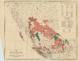
Item consists of a map of British Columbia showing Status of Sustained-Yield Forestry Programme as at December 31, 1969 with colour coded areas indicating Public Sustained Yield Units, Special Scale Areas, Tree Farm Licences, and Major Parks.
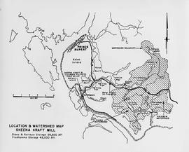
Item is a map showing the watersheds of Diana Lake, Rainbow Lake and Prudhomme Lake.
Map is an original linen Aleza Lake Experiment Forest map that reflects the reserve boundary, roads, trails, 20 feet contour intervals, air photo centre, declination, swamps, and mile posts.
Map reproduction of the Aleza Lake Research Forest depicts timber sale areas, forest cover, and other details.
Item is a hand-drawn map of a plot in the Aleza Lake Research Forest. Individual trees are marked and numbered.
Item is a hand-drawn map of a plot in the Aleza Lake Research Forest. Individual trees are marked and numbered.
Item is a hand-drawn map of a plot in the Aleza Lake Research Forest. Individual trees are marked and numbered.
Item is a hand-drawn map of a plot in the Aleza Lake Research Forest. Individual trees are marked and numbered.
Mylar map is a plot map of a research plot at the Aleza Lake Research Forest. Provides date the plot was established, the harvest history, the silviculture history, remeasurement history, and information about individual trees.
Mylar map is a plot map of a research plot at the Aleza Lake Research Forest. Provides date the plot was established, the harvest history, the silviculture history, remeasurement history, and information about individual trees.
Mylar map is a plot map of a research plot at the Aleza Lake Research Forest. Provides date the plot was established, the harvest history, the silviculture history, remeasurement history, and information about individual trees.
Mylar map is a plot map of a research plot at the Aleza Lake Research Forest. Provides date the plot was established, the harvest history, the silviculture history, remeasurement history, and information about individual trees.
Map depicts historical timber sales areas and permanent sample plots (PSPs) at the Aleza Lake Research Forest. This map may be a guide (or otherwise related) to maps 2006.18.5.43-59.
Item is a British Columbia Forest Cover Map, serial number 093J010. Includes full format forest cover labels.
Item is a British Columbia Forest Cover Map, serial number 093J010. Includes full format forest cover labels.
Item is a Forest Cover Map, 93J-7, annotation on the back reads Summit Lake. Geographical features include Summit Lake and Crooked River.
Item is McBride, B.C. Sheet 93H and Part of 83E Second Status Edition (1971) from "Classification and Interpretation of some Ecosystems of the Rocky Mountain Trench, Prince George Forest Region, British Columbia: First Approximation" (1984).


