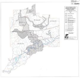
Map commissioned from Ministry of Forests Prince George Region from Madrone Consultants shows Aleza Lake Research Forest Management Compartments and Administrative Boundaries. Map is 1 of 6. Map shows the Aleza Lake Ecological Reserve, Natural Forest Reserve, the Special Management Area, and Riparian Management Research Area.
Map commissioned from Ministry of Forests Prince George Region from Madrone Consultants shows Aleza Lake Research Forest Research Trials and Permanent Plots. Map is 2 of 6. Map shows permanent plot locations, historical timber sales areas, demonstration areas, and research plots.
Map commissioned from Ministry of Forests Prince George Region from Madrone Consultants shows Aleza Lake Research Forest Access and Access Management. Map is 3 of 6. Map shows the following road types: all weather 1-lane gravel road, dry weather road, and proposed road access. Also shows areas for parking/turnaround, toilets, and information signs.
Map commissioned from Ministry of Forests Prince George Region from Madrone Consultants shows an Aleza Lake Research Forest TRIM Base Map. Map is 4 of 6. Map shows the following: roads, old roads, buildings, rail line, transmission line, definite streams, intermittent streams, indefinite streams, marshes, swamps, lakes, wooded area boundaries, intermediate contour lines (20m intervals), and index contour lines (100m intervals).
Map commissioned from Ministry of Forests Prince George Region from Madrone Consultants shows Aleza Lake Research Forest ecosystems. Map is 5 of 6. Map shows many sub-types of the following ecosystem types: upland, lowland wet forest, wetlands, and the Bowron floodplain benches. Ecosystem classification and mapping by Oikos Ecological Services Ltd.
Map commissioned from Ministry of Forests Prince George Region from Madrone Consultants shows Aleza Lake Research Forest terrain themes. Map is 6 of 6. Map shows the following types of terrain units: typic, slope, percipitous, gullied, hummocky, rocky, alluvial, and organic. Ecosystem classification and mapping by Oikos Ecological Services Ltd.
Map commissioned from Ministry of Forests Prince George Region from Madrone Consultants shows Aleza Lake Research Forest Terrain Resource Inventory Mapping (TRIM). Depicts roads, area boundaries, swamps, streams, marshes, contour lines and index lines.
Map commissioned from Ministry of Forests Prince George Region from Madrone Consultants shows Aleza Lake Research Forest site series classification. Shows ecosystem types that encompass the SBSwk1 Subzone of the Aleza Lake Research Forest.
Map reflects reserve boundary, roads, trails, 20 feet contour intervals, air photo centre, declination, swamps, and mile post at the Aleza Lake Experiment Forest.
Map reflects reserve boundary, roads, trails, 20 feet contour intervals, air photo centre, declination, swamps, and mile post at the Aleza Lake Experiment Forest.
Map reflects reserve boundary, roads, trails, 20 feet contour intervals, air photo centre, declination, swamps, and mile post at the Aleza Lake Experiment Forest.
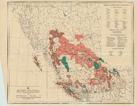
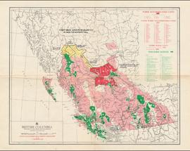
Item consists of a map of British Columbia showing Status of Sustained-Yield Forestry Programme as at December 31, 1969 with colour coded areas indicating Public Sustained Yield Units, Special Scale Areas, Tree Farm Licences, and Major Parks.
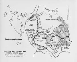
Item is a map showing the watersheds of Diana Lake, Rainbow Lake and Prudhomme Lake.
Item is a map that distinguishes the regions covered by Tree Farm Licence No. 1 granted to Columbia Cellulose and Three Farm Licence No. 40 granted to Skeena Kraft. Major locations indicated in this map include: Prince Rupert, Terrace, Hazelton, Smithers, Kitimat, Skeena River, and Nass River. Railway routes are also shown.
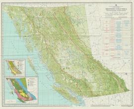
Item is a map of British Columbia and is a key map showing: maps published on scale 1 inch to 2 miles and summary zones of the provincial forest inventory. Map includes index of post offices correct to October 22, 1956.
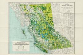
Item is a map of British Columbia's Status of Sustained-Yield Forestry Programme as at 31 December 1962. The map has been annotated to show forest area surveyed by Celgar Ltd. as base for new kraft mill.
Item is a map compiled and produced by Geographic Division, Surveys and Mapping Branch, Department of Lands, Forests, and Water Resources ; geological and physiographical data supplied by Dept. of Mines and Petroleum Resources, Victoria, B.C. (1964).
Item is an original draft copy of "Regional Landscapes for the British Columbia Parks System".
