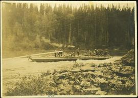
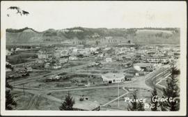
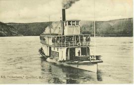
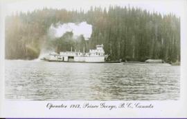
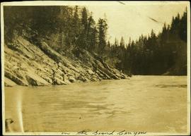
Aperçu avant impression Fermer

Affichage de 3756 résultats

Archival description
3615 résultats avec objets numériques Afficher les résultats avec des objets numériques
2009.5.3.8 · Pièce · [ca. 1913]
Fait partie de Taylor-Baxter Family Photograph Collection

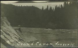
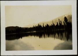
Photograph depicts a line of men standing on opposite shore and holding a long rope between them, while men on scow float close to shore in distance. River water in foreground, trees on shore in background. Handwritten photo caption on verso and recto of this photograph reads: "In the Grand Canyon."

Scow's Last Lap
2009.5.3.10 · Pièce · [ca. 1913]
Fait partie de Taylor-Baxter Family Photograph Collection

Photograph depicts a crew of 13 men on a scow believed to be maneuvering through the Upper Fraser River at Scow's Last Lap (Scow Rapids), downriver from the Grand Canyon of the Fraser. Trees on opposite shore in background, rocky shore in foreground. Handwritten annotation on recto of photograph reads: "the last lap".

Dangerous Point at Giscome Rapids
2009.5.3.15 · Pièce · [ca. 1913]
Fait partie de Taylor-Baxter Family Photograph Collection

Photograph depicts the Giscome Rapids. Opposite shore in background, rocky beach in foreground. Handwritten photo caption on verso and recto of this photo reads: "Point where G.T.P. [Grand Trunk Pacific] canoe capsized at Giscome Rapids & where 3 men were drowned."

Fort George from Across the Fraser River
2009.5.3.28 · Pièce · [ca. 1912]
Fait partie de Taylor-Baxter Family Photograph Collection

Photograph depicts the early settlement of Fort George. The buildings to the left of the fence are believed to be owned by the Hudson's Bay Company. The land to the right of the fence belonged to the Fort George Reserve, the home of today's Lheidli T'enneh Band who relocated to a reserve at Shelley when this reserve was sold in 1912. Handwritten annotation on verso and recto of this photograph reads: "Fort George from opposite side of Fraser River".

Bourchier Scow on Fraser River, BC
2009.5.3.43 · Pièce · [ca. 1913]
Fait partie de Taylor-Baxter Family Photograph Collection

Photograph depicts group of men seated on scow carrying unidentified material. One man stands on rocky shore in left foreground, leaning on plank attached to scow. A second scow can be seen behind men. Tree-covered hills on opposite shore in background.

2009.5.4.52 · Pièce · [ca. 1912]
Fait partie de Taylor-Baxter Family Photograph Collection

Photograph depicts four men on conveyor, and clear view of paddle wheel. A small boat is docked to the conveyor with men and equipment. Crowd of men on shore in foreground on right, trees on opposite shore in background. Mountains visible in distance. Handwritten annotation on verso of photograph reads: "Str. Conveyor".

McBride, BC in 1914
2009.5.3.57 · Pièce · 1914
Fait partie de Taylor-Baxter Family Photograph Collection

Photograph depicts street in McBride, wood buildings and tent buildings on either side. Small businesses and restaurants line the left side of the street. Forest slash stands in newly cleared area in foreground. Railway tracks cross right foreground, hills visible in background. Annotation on verso of photograph reads: "MC.Bride, B.C.", handwritten on recto: "1914 [Bourchier?]"

Sand Creek on Fraser River, BC
2009.5.3.72 · Pièce · [ca. 1912]
Fait partie de Taylor-Baxter Family Photograph Collection

Photograph depicts small log buildings and loaded wagons in cleared dirt area. Building on far left has the sign "POOL HALL" posted on front . Treetops, lumber piles, and hills in background. Mountains can be seen in distance. Handwritten annotation on verso of photograph reads: "Sand Creek. B.C."

2009.5.3.79 · Pièce · [193-]
Fait partie de Taylor-Baxter Family Photograph Collection

Photograph depicts crowd of people in foreground near log fence. More crowds can be seen in distance at base of ski jump on either sides of the run. Jump visible at top of tree-covered hill in background. It is believed that this photograph was taken near the current location of City Hall.

Prince George Townsite, From Above
2009.5.3.81 · Pièce · [ca. 1940]
Fait partie de Taylor-Baxter Family Photograph Collection

Photograph depicts the major buildings and streets of the town. Sloped cutbank visible across the Nechako River in background. It is believed that this photograph was taken from Connaught Hill. Handwritten annotation on verso of photograph reads: "PRINCE GEORGE, B.C."

Grand Canyon, Fraser River
2009.5.3.103 · Pièce · [ca. 1910]
Fait partie de Taylor-Baxter Family Photograph Collection

Photograph depicts an unidentified person seated on rocks in foreground. River crosses midground, cliffs and trees on opposite shore in background. Unidentified structures believed to be buildings can be seen on opposite shore. Handwritten annotation on verso of photograph: "Grand Canyon. fraser R."

Taku River Survey - Kopoka Glacier
2006.20.3.6 · Pièce · [between 29 August 1906 and 9 October 1906]
Fait partie de Northern BC Archives Historical Photograph Collection

Photograph depicts glacier in valley below mountains. Handwritten annotation on negative: "K. Glacier [...illegible]".

Image is one of 65 photos documenting a survey of the Canada-Alaska Boundary, Taku River area, May 23 to Oct. 15, 1906.
This particular photo is one of 13 found in original enclosure with the following handwritten annotation: "Kopoka River - river scenes Aug 29 to Oct. 9 [19]06". See also items 2006.20.3.1 - 2006.20.3.13.

Taku River Survey - Campsite
2006.20.3.7 · Pièce · [between 29 August 1906 and 9 October 1906]
Fait partie de Northern BC Archives Historical Photograph Collection

Photograph depicts tent among trees, hills visible in background.

Image is one of 65 photos documenting a survey of the Canada-Alaska Boundary, Taku River area, May 23 to Oct. 15, 1906.
This particular photo is one of 13 found in original enclosure with the following handwritten annotation: "Kopoka River - river scenes Aug 29 to Oct. 9 [19]06". See also items 2006.20.3.1 - 2006.20.3.13.

2006.20.3.9 · Pièce · [between 29 August 1906 and 9 October 1906]
Fait partie de Northern BC Archives Historical Photograph Collection

Photograph depicts river and rocky shores, glacier visible on mountain in background. Handwritten annotation on negative: "Glacier [?] Kopoka".

Image is one of 65 photos documenting a survey of the Canada-Alaska Boundary, Taku River area, May 23 to Oct. 15, 1906.
This particular photo is one of 13 found in original enclosure with the following handwritten annotation: "Kopoka River - river scenes Aug 29 to Oct. 9 [19]06". See also items 2006.20.3.1 - 2006.20.3.13.

2006.20.3.15 · Pièce · [between 23 May 1906 and 15 October 1906]
Fait partie de Northern BC Archives Historical Photograph Collection

Photograph depicts two unidentified men standing and sitting at campfire by large fallen trees. Forest and mountains in background. Handwritten annotation on negative: "[?] Taken Near Kopoka".

Image is one of 65 photos documenting a survey of the Canada-Alaska Boundary, Taku River area, May 23 to Oct. 15, 1906.
This particular photo is one of 8 found in original enclosure with the following handwritten annotation: "From main camp up Kopoka River. Scenes with persons in." See also items 2006.20.3.14 - 2006.20.3.21.

2006.20.3.20 · Pièce · [between 23 May 1906 and 15 October 1906]
Fait partie de Northern BC Archives Historical Photograph Collection

Photograph depicts unknown man standing in water while pulling loaded canoe by rope. Rocky shore in foreground, mountains in background. Handwritten annotation visible on negative: "[?] hauling canoe. Big [?], Kopoka".

Image is one of 65 photos documenting a survey of the Canada-Alaska Boundary, Taku River area, May 23 to Oct. 15, 1906.
This particular photo is one of 8 found in original enclosure with the following handwritten annotation: "From main camp up Kopoka River. Scenes with persons in." See also items 2006.20.3.14 - 2006.20.3.21.

2006.20.3.21 · Pièce · [between 23 May 1906 and 15 October 1906]
Fait partie de Northern BC Archives Historical Photograph Collection

Photograph depicts three unknown men standing in water while pulling loaded canoe by rope. Rocky shore and hills in background. Illegible handwritten annotation visible on negative: "...[K. River]?" (Kopoka?)

Image is one of 65 photos documenting a survey of the Canada-Alaska Boundary, Taku River area, May 23 to Oct. 15, 1906.
This particular photo is one of 8 found in original enclosure with the following handwritten annotation: "From main camp up Kopoka River. Scenes with persons in." See also items 2006.20.3.14 - 2006.20.3.20.

2006.20.3.23 · Pièce · [between 23 May 1906 and 15 October 1906]
Fait partie de Northern BC Archives Historical Photograph Collection

Photograph depicts man [Gilroy?] sitting with small tin cup. Canoe lies upside down in foreground. Water and opposite shore visible in background. Handwritten annotation visible on negative: "Camp. [Gilroy?] on way up from trail. 9 pm".

Image is one of 65 photos documenting a survey of the Canada-Alaska Boundary, Taku River area, May 23 to Oct. 15, 1906.
This particular photo is one of 13 found in original enclosure with the following handwritten annotation: "SOME OTHERS." See also items 2006.20.3.22 - 2006.20.3.34.

Taku River Survey - Two Men at Flag
2006.20.3.26 · Pièce · [between 23 May 1906 and 15 October 1906]
Fait partie de Northern BC Archives Historical Photograph Collection

Photograph depicts two unidentified men standing to right of flag mounted in rock pile.

Image is one of 65 photos documenting a survey of the Canada-Alaska Boundary, Taku River area, May 23 to Oct. 15, 1906.
This particular photo is one of 13 found in original enclosure with the following handwritten annotation: "SOME OTHERS." See also items 2006.20.3.22 - 2006.20.3.34.

2006.20.3.35 · Pièce · [between 23 May 1906 and 15 October 1906]
Fait partie de Northern BC Archives Historical Photograph Collection

Photograph depicts two men standing on mountain with walking sticks, carrying bundles on their backs. Valley and mountains visible in background below. Handwritten annotation visible on negative: "[?] Climbing [?] Sta - K. River" (Kopoka?).

Image is one of 65 photos documenting a survey of the Canada-Alaska Boundary, Taku River area, May 23 to Oct. 15, 1906. This particular photo is one of 7 found in original enclosure with the following handwritten annotation: "Around River Taku and main camp on same." See also items 2006.20.3.35 - 2006.20.3.41.

2006.20.3.38 · Pièce · [between 23 May 1906 and 15 October 1906]
Fait partie de Northern BC Archives Historical Photograph Collection

Icebergs can be seen in foreground, opposite shore crosses midground, mountains stand in background.

Image is one of 65 photos documenting a survey of the Canada-Alaska Boundary, Taku River area, May 23 to Oct. 15, 1906. This particular photo is one of 7 found in original enclosure with the following handwritten annotation: "Around River Taku and main camp on same." See also items 2006.20.3.35 - 2006.20.3.41.

2006.20.3.41 · Pièce · [between 23 May 1906 and 15 October 1906]
Fait partie de Northern BC Archives Historical Photograph Collection

Water spans foreground, trees on shore can be seen on far left, mountains stand in background.

Image is one of 65 photos documenting a survey of the Canada-Alaska Boundary, Taku River area, May 23 to Oct. 15, 1906. This particular photo is one of 7 found in original enclosure with the following handwritten annotation: "Around River Taku and main camp on same." See also items 2006.20.3.35 - 2006.20.3.40.

Taku River Survey - Mountain Scene
2006.20.3.42 · Pièce · [between 23 May 1906 and 15 October 1906]
Fait partie de Northern BC Archives Historical Photograph Collection

View of snowy mountain range.

Image is one of 65 photos documenting a survey of the Canada-Alaska Boundary, Taku River area, May 23 to Oct. 15, 1906. This particular photo is one of 5 found in original enclosure with the following handwritten annotation: "Boundary No.2 camera Sta. Twin Lake & Glacier.” See also items 2006.20.3.43 - 2006.20.3.46.

Taku River Survey - Cliffs on Shore
2006.20.3.43 · Pièce · [between 23 May 1906 and 15 October 1906]
Fait partie de Northern BC Archives Historical Photograph Collection

Water spans foreground, cliffs cross midground, mountains stand in background.

Image is one of 65 photos documenting a survey of the Canada-Alaska Boundary, Taku River area, May 23 to Oct. 15, 1906. This particular photo is one of 5 found in original enclosure with the following handwritten annotation: "Boundary No.2 camera Sta. Twin Lake & Glacier.” See also items 2006.20.3.42 - 2006.20.3.46.

2006.20.3.48 · Pièce · [between 23 May 1906 and 15 October 1906]
Fait partie de Northern BC Archives Historical Photograph Collection

Photograph depicts mountain range, river or glacier visible below.

Image is one of 65 photos documenting a survey of the Canada-Alaska Boundary, Taku River area, May 23 to Oct. 15, 1906. This particular photo is one of 10 found in original enclosure with the following handwritten annotation: "From [Wahut?]-Azmuth and Koshu.” See also items 2006.20.3.47 - 2006.20.3.56.

Taku River Survey - Tent in Forest
2006.20.3.50 · Pièce · [between 23 May 1906 and 15 October 1906]
Fait partie de Northern BC Archives Historical Photograph Collection

Photograph depicts small tent set up in bushes, fallen trees in foreground.

Image is one of 65 photos documenting a survey of the Canada-Alaska Boundary, Taku River area, May 23 to Oct. 15, 1906. This particular photo is one of 10 found in original enclosure with the following handwritten annotation: "From [Wahut?]-Azmuth and Koshu.” See also items 2006.20.3.47 - 2006.20.3.56.

Taku River Survey - Mountains & Valley
2006.20.3.51 · Pièce · [between 23 May 1906 and 15 October 1906]
Fait partie de Northern BC Archives Historical Photograph Collection

Photograph depicts river or glacier in valley bellow mountains. Handwritten annotation visible on negative: "From No. 2 Cam. Sta. [?] Taku River [?]".

Image is one of 65 photos documenting a survey of the Canada-Alaska Boundary, Taku River area, May 23 to Oct. 15, 1906. This particular photo is one of 10 found in original enclosure with the following handwritten annotation: "From [Wahut?]-Azmuth and Koshu.” See also items 2006.20.3.47 - 2006.20.3.56.

Taku River Survey - Mountain Scene
2006.20.3.53 · Pièce · [between 23 May 1906 and 15 October 1906]
Fait partie de Northern BC Archives Historical Photograph Collection

Photograph depicts river or glacier in valley bellow mountains, flat snowy area in foreground.

Image is one of 65 photos documenting a survey of the Canada-Alaska Boundary, Taku River area, May 23 to Oct. 15, 1906. This particular photo is one of 10 found in original enclosure with the following handwritten annotation: "From [Wahut?]-Azmuth and Koshu.” See also items 2006.20.3.47 - 2006.20.3.56.

2006.20.9.10 · Pièce · 1911
Fait partie de Northern BC Archives Historical Photograph Collection

Photograph depicts men on sternwheeler in river, opposite shore in background.

Printed annotation on recto reads: “S.S. “Charlotte,” Quesnel. B.C.” Handwritten message on verso is addressed to “Mr. O. Winter 1016 V Park St. Victoria B.C.” Cancellation stamp on Canadian 1 cent stamp reads: "ASHCROFT B.C. JUN [10?] 11".

Cassiar - Stewart Highway
2006.20.9.25 · Pièce · [ca. 1897 - 1960]
Fait partie de Northern BC Archives Historical Photograph Collection

View of snow capped mountains in the distance, vast rolling treed hills in mid ground and a gravel road in the foreground. Road sign indicating severe curve in road situated at the right of the gravel road. Handwritten annotation on verso in pen reads: “Cassiar – Stewart highway”

Bridge over Dog Creek
2006.20.11.5 · Pièce · June 1923
Fait partie de Northern BC Archives Historical Photograph Collection

Photograph depicts a short wooden bridge spanning Dog Creek mid-ground and a stand of trees in the background. There are many Dog Creeks within British Columbia, it is believed this Dog Creek is located just south of Fort St. James, BC. Handwritten photo caption below photograph reads: "Dog Creek".

Lake Beauvert and Whistler Mountains
2006.20.11.18 · Pièce · June 1923
Fait partie de Northern BC Archives Historical Photograph Collection

Photograph depicts a glassy body of water with trees on opposite bank crossing mid ground. Mountains visible in distant background. A clear reflection of the trees and mountains is mirrored in the water. Handwritten photo caption below photograph reads: "The Whistlers across Lake Beau Vert (7. AM.)"

Pearl Street in Atlin, BC
2006.20.11.22 · Pièce · August 1899
Fait partie de Northern BC Archives Historical Photograph Collection

Photograph depicts buildings and signage on either side of dirt road. Unidentified man stands on far left, Atlin Lake and mountains can be seen in background.

Hand inscribed annotation on recto of photograph reads: “Pearl St., Atlin, B.C. Aug. 1899. A.C. Hirschfeld, No.74”.

Pearl Avenue in Atlin, BC
2006.20.11.23 · Pièce · [ca. 1899]
Fait partie de Northern BC Archives Historical Photograph Collection

Photograph depicts tent buildings on either side of dirt road. Unidentified men are visible on left, Atlin Lake and mountains can be seen in background.

Hand inscribed annotation on recto of photograph reads: “Pearl Av. looking towards Atlin Lake, Atlin, B.C., A.C. Hirschfeld, No. 174”

First Passenger Engine at Prince Rupert
2009.7.1.248 · Pièce · ca. 1880-1920
Fait partie de Archdeacon W. H. Collison fonds

Head on shot of steam engine traveling through a pass with mountains in the background. Handwritten annotation in pen on verso reads: "First Passenger Engine to reach Prince Rupert." Annotation on recto reads: "First Passenger Engine at Prince Rupert." Photographer' stamp in bottom right corner of recto reads : "Allen Photo."

Side view of Prince Rupert wharf
2009.7.1.274 · Pièce · May 1908
Fait partie de Archdeacon W. H. Collison fonds

Side view photograph of a small harbor close by a shoreline littered in organic debris. A foggy mountain range is visible in the background. Annotation on recto reads: "Wharf and Harbor Prince Rupert. May 1908 JDA."

Across the bay
2009.7.1.276 · Pièce · [ca. 1880-1920]
Fait partie de Archdeacon W. H. Collison fonds

Photograph of the bay at dusk. Trees and distant machinery are silhouetted against a cloudy sky and dark waterfront. Annotation on recto reads: "Across the Bay, Prince Rupert, BC No 4466."

Overview of Eagle Lake looking East
2011.12.05 · Pièce · [ca. September 1950- June 1951]
Fait partie de Giscome, BC Historical Photograph collection

Photograph of various plant life with Eagle Lake visible in the background. Handwritten annotation in pen on verso reads: “Eagle Lake from the top of the bluff. Eagle Lake is about 7 miles long & about 1 mile wide. It is a fair sized lake.”