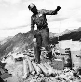
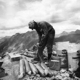
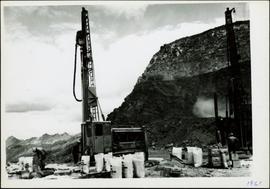
Photograph depicts men standing near two Atlas Copco Drillmasters (blasthole drills). These are precision hammer drills which had their own power source. Large bags of ammonium nitrate in foreground, mountainside in background. The men depicted here were likely members of the explosive crew. It is believed that this photo was taken on the North ridge, near the cirque dump. Handwritten annotation on verso of photograph: "1961".
Photograph depicts a man wearing a hard hat preparing long narrow bags of explosive material. Large bags of ammonium nitrate in right foreground, mountains in background. Handwritten annotation on verso of photograph: "1961".
Photograph depicts crawler cable shovel and dump truck in excavation area of mine. Handwritten annotation on verso of photograph: "1961".
Photograph depicts various buildings in plantsite, vehicles and electricity lines throughout. Equipment garage stands in left background behind tank farm, carpenter shop in right background, machine and electrical shop in building semi-visible on far right. Mine road can be seen at foot of mountain in background. Handwritten annotation on verso of photograph: "1961".
Photograph depicts a gravel road passing under crossing. Sign posted to pole reads "CAUTION TRAMLINE CROSSING CAUTION AVIOD PASSING UNDER MOVING BUCKETS". Garage stands in left midground, mountains in background. Handwritten annotation on verso of photograph: "1961".
Photograph depicts long wood building speculated to be the Community Centre at Cassiar, B.C. Sports net stands in right foreground. Flag pole, barrel, and stand of trees can be seen in front of building. Mountains in background. Handwritten annotation on verso of photograph: "1961".
Photograph depicts four houses in line behind trees and steel drums. Road in foreground, mountains in background. Handwritten annotation on verso of photograph: "1961".
Photograph depicts long bunkhouse buildings located between the Cassiar plant and townsite. They were originally used seasonally by university students, or by new employees on waiting lists for the more accommodating panabode "Winter Bunkhouses" (see item 2000.1.1.3.19.113). These buildings are speculated to be bunkhouses number 86, 87, and 88. Trees cross midground; new mill building, tailings pile, and mountains visible in background. Handwritten annotation on verso of photograph: "Cassiar June 15 71".
Photograph depicts a Chevrolet pickup truck on highway to right of Mud Lake, at Km 632 on the Stewart-Cassiar Highway. Forest on hillside in background.
Photograph depicts ore cars on cables running between tramline towers. Flowers in foreground, mine valley and McDame mountain in background. Tramline ran through mine valley, between loading station (2000.1.13.19.197) in mine and dump station at mill on plantsite (2000.1.1.3.19.124)
Photograph depicts mountain side mostly covered in snow. Corresponding note on accompanying photo description page: "10. Snow on mountain slope above road between where mountain road starts and the first switchback. This snow will melt and the water must still pass over or along road."
File contains photographs documenting the construction of Cassiar's new mill building. Photos depict early excavation, foundations, framework, construction of all seven stories, sheeting, siding, and roof tarring. Also included are photos depicting the large model of the mill, as well as construction work done on the tramline. Photos taken inside the mill depict flooring work, and milling machinery including feed chutes, screens, fans, wheelabrators, control panels, electrical panels, conveyor systems, vacuum systems, and the fan-driven air system that transported the fiber. Many photos depict construction workers, building supplies, worksites, and equipment including cranes, bulldozers, tractors, hauling trucks and trailer flatbeds. Some photos depict aerial views from the new mill and feature the plantsite, tramline, mine road, mountains, and valley.
Photograph depicts two unidentified men playing tennis in foreground. Buildings stand in midground, including what appears to be the All Saints Anglican Community Church. Forest and mountain in background.
Photograph depicts church believed to be the All Saints Anglican Community Church at Cassiar, B.C. Trees and fence in foreground, forest and mountain in background.
Photograph depicts tramline conveyor in centre of image (located west of mine). Conveyor ran from crusher plant to tramline loading station. Building on left believed to be the crusher reject plant. Mine valley and northwestern mountain range in background.
Photograph depicts group of eleven men standing in line in the Cassiar valley. Left to right: Jack Christian, Charles Rainforth Elliot, John Drybrough, John E. Kennedy, Fred Martin Connell, W. Harold Connell, Ken A. Creery, George Washington Smith, Tam Zimmermann, [Fred Murray]?, Nick Gritzuk. Creery looks through his own camera, appearing to photograph the photographer. Power lines and mountains in background. Most men featured in photo are believed to be members of Cassiar's Board of Directors.