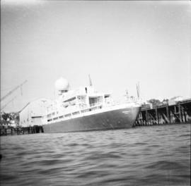
Imprimir vista previa Cerrar

Mostrando 4073 resultados

Archival description
Weather ships, Sea Island
2013.6.36.1.062.06 · Item · Oct. 1969
Parte de David Davies Railway Collection

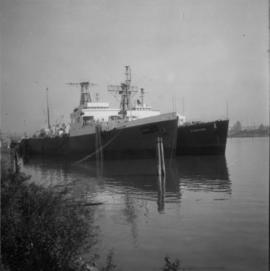
Photograph depicts decommissioned weather ships. One was named "Stonetown." They were formerly coastguard vessels that were in use until 1968. Prior to that, they were corvettes of the RCN and moored in Vancouver Harbour at the Terminal Pier.

Weather ship "Vancouver"
2013.6.36.1.062.01 · Item · 1966
Parte de David Davies Railway Collection

Photograph depicts a weather ship of the Canadian Coastguard called "Vancouver." It was fitting out after launching. This vessel and its sister ship, "Quada," were the largest vessels ever built on the western coast of Canada. "Vancouver" was retired in May 1981 as it was too costly to service.

2009.7.1.137 · Item · [ca. 1910?]
Parte de Archdeacon W. H. Collison fonds

Three men can be seen on deck of small boat. Rocky shore in foreground, forest and hills on opposite shore in background.

Handwritten annotations on verso read: "Dad - en route up Nass River on official business. (hence the flag & business suit!)"; "Going up the Nass. Dad (Indian Agent) Cap Barry (Inspect. of Schools) travelling up the Nass River to Aiyansh".

2009.7.1.140 · Item · [ca. 1925?]
Parte de Archdeacon W. H. Collison fonds

Group of six men sit and stand on small boat close to shore. Rev. W.E. Collison stands on far right (son of Marion and Archdeacon W.H. Collison).

Handwritten annotation on verso reads: "Dr. Macdonald Med officer (Kincolith) / Dr. [McQuarrie?] Med officer Victoria / Steven Clayton Native boat owner / Capt. Bary - Insp. of Indian Schools / W.E. Collison Indian agent. / Inspection trip to villages of upper Nass River".

2013.6.36.1.021.05 · Item · [24 May 1973]
Parte de David Davies Railway Collection

Photograph depicts an abandoned water tower on CPR line at Brookmere, 30 miles south of Merritt. The trackage on the right has had the spikes removed but the yard consists of a mixture of completely removed, partially removed, and completely undisturbed track. An elderly couple and 2 elderly bachelors are the only year-round remaining inhabitants.

2013.6.36.1.027.19 · Item · [July 1966]
Parte de David Davies Railway Collection

Photograph depicts a water tank car on the CPR line at Rock Creek. Rock Creek is located at mile 11.7 from Midway and east of Osoyoos. The water tank car was built in 192, holds 8000 gallons, and forms part of a work train. The sidings capacity here is 70 cars.

Water car on the CPR line at Nelson
2013.6.36.1.028.42 · Item · 18 Sept. 1970
Parte de David Davies Railway Collection

Photograph depicts water car #415319 standing on a little used spur in Nelson. It consists of a locomotive tender mounted on a flat car. It could be used as a firefighting unit, but it is merely lettered "service."

Washroom at CPR McCulloch depot
2013.6.36.1.026.08 · Item · [22 June 1979]
Parte de David Davies Railway Collection

Photograph depicts the washrooms on the west side of the line, about a quarter mile from the McCulloch CPR depot building. The depot is located at mile 76.6 on the Carmi Subdivision.

2009.5.1.73 · Item · 26 May 1932
Parte de Taylor-Baxter Family Photograph Collection

Handwritten annotation on recto of photograph: "Omineca Dist Walcott Suspension Bridge West Approach - looking East May 26 - 1932". Photograph depicts two white horses pulling a wagon in front of Walcott bridge. This bridge was moved from its original location in the Hagwilget Canyon, downstream from Walcott on the Bulkley River. It is a pedestrian bridge at the time of this photograph, though it was originally used by motor vehicles. Dirt road leading to bridge in foreground, with lumber and brush piles on either side. Trees and hills on opposite shore in background.

W.A.C. Bennett Dam?
2012.13.1.91.44 · Item · 1979
Parte de J. Kent Sedgwick fonds

Image depicts several unidentified individuals lying on a hill outside what is most likely the W.A.C. Bennett Dam in Hudson's Hope, B.C.

View of Whitehorse Airfield from Tower
2006.20.12.43 · Item · [ca. 1940]
Parte de Northern BC Archives Historical Photograph Collection

Handwritten photo album caption below this photo reads: "Another view of Whitehorse Field from the Tower." Photograph depicts various unidentified buildings at what is believed to the Royal Canadian Air Force base in Whitehorse, YT. Small sign in foreground reads: "Taking Photographs Prohibited" (see also items 2006.20.12.1 & 2006.20.12.39). Mountains in background.

Sin título
View of tracks from McCulloch CPR depot
2013.6.36.1.026.18 · Item · [22 June 1979]
Parte de David Davies Railway Collection

Photograph depicts a view of four tracks at the McCulloch CPR depot, located at mile 76.6, on the Carmi Subdivision. The four tracks, west to east, are: a passing track, the mainline, a storage track, and a turning "Y". The rail on the passing track and mainline are date 1940, and the others are 1918 or 1919. The view is looking southwest.

2006.20.12.35 · Item · [ca. 1940]
Parte de Northern BC Archives Historical Photograph Collection

Handwritten photo album caption below this photo reads: "Above the Rockies at 12 000 feet." Photograph depicts the Rocky Mountains from a distance. As the photograph was taken from the inside of an airplane, the plane's wing tip can be seen on the far right of the image. A sun circle is also visible in the top center.

Sin título
2013.6.36.1.003.101 · Item · [May 1966]
Parte de David Davies Railway Collection

Photograph depicts a view of the Fraser River from the Albion Ferry from Haney to Fort Langley. The ferry is approaching the south bank of Fort Langley. Gulls sat on logs floating downstream; too heavy to rise after eating candlefish.

View of Summit Lake
2005.3.50 · Item · [ca. 1945]
Parte de John Hart Highway Photograph Collection

Handwritten caption beside this photo reads: "Sumit Lake." Trees can be seen on shore jutting into the lake on left, as well as on opposite shore in distant background. Unidentified objects can be seen in distance, possibly buildings on far shore.

View of Seton Lake area
2020.08.77 · Item · [between 1911 and 1915]
Parte de Pacific Great Eastern Railway Region Photograph Collection

Photograph depicts a view of Seton Lake and the surrounding area, including the Pacific Great Eastern railway line. The railway grade is visible at left. Also visible is the Seton Lake fish hatchery at the east end of the lake and its employee boarding house, superintendent's cottage, and weir at the head of what was then referred to as "Lake Creek". The road seen in the centre foreground travelled from Lillooet to Seton Lake then to Golden Cache Mine.

View of Prince George, BC from Above
2011.3.2.13 · Item · 1921
Parte de North Coast & Central BC Postcard Collection

Boardwalk in foreground, buildings and roads in mid ground, cut banks in background. Printed annotation on recto reads: “Prince George. B.C. 1921 by Moore”. Handwritten annotation in ink on verso reads: “The Netchaco river is between the mountain and the city and the C.N.R. runs along the river bank nearest the city. This picture is taken looking north.”

View of harbour road in Vancouver
2013.6.36.1.015.14 · Item · 15 Oct. 1974
Parte de David Davies Railway Collection

Photograph depicts an unnamed harbour road that runs to the north of , and parallel to Water St. The trackage is connected behind the camera to a CPR depot and at the other end to the mainline. No spurs lead off to the docks. The track is not used but usable.

View of Fort Wrangell, Alaska
2006.45.17 · Item · [ca. 1897]
Parte de Historical North Coast Photograph Album

View of town on shore, from above. Boats docked along piers and buildings. Hills visible on either side of water in background.

Handwritten photo captions with arrows pointing to sections of image read: "General Merchandise", "Fort Wrangell Hotel".

View of Fort George, B.C. from Above
2011.3.2.05 · Item · 1913
Parte de North Coast & Central BC Postcard Collection

Lofty view of South Fort George, river and treed hills in the background. Printed annotation on verso reads: “South Fort George - 1913.” Handwritten message on recto is addressed to “Ethel M. Heurris Norton Maps Bristol County" reads: "11-1-13 an excellent view of south Fort George taken recently. Power Station at cross near water. This does not give all the south residence view. Population approx 1500”.