2000.1.1.4.4.2
·
Pièce
·
1963
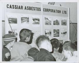
Fait partie de Cassiar Asbestos Corporation Ltd. fonds
Photograph depicts group of young boys observing "CASSIAR ASBESTOS CORPORATION LTD" display table. Table features photos existing in this archival collection (see items 2000.1.1.3.19.10 and 2000.1.1.3.19.11). Photo speculated to have been taken at an event in Vernon, B.C. Handwritten annotation on verso of photograph: "1963".