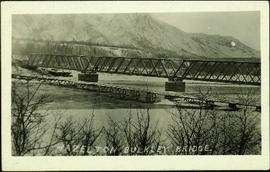
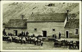
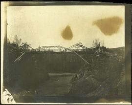
Close view of bridge built with wooden planks, poles, and wires, braced from below, with triangles built into its frame. The bridge crosses Hagwilget Canyon on the Bulkley River, five kilometres from its confluence with the Skeena River. This is one of the many bridge structures that have crossed this location since at least 1859. Photograph was taken from one side of canyon, near bridge. Opposite canyon wall in background. Typed annotation glued to verso of photograph: "HAGWILGET - 'the gentle or quiet people'."
Photograph depicts two men and a horse on a bridge built with wooden planks, poles, and wires, braced from below, with triangles built into its frame. The bridge crosses Hagwilget Canyon on the Bulkley River, five kilometres from its confluence with the Skeena River. This is one of the many bridge structures that have crossed this location since at least 1859. Photograph was taken from a distance. Rocky riverbank in foreground, opposite shore in background behind bridge. Typed annotation in red ink on verso of photograph: "INDIAN BRIDGE, NEAR HAZELTON, B.C."
Photographs within this file pertain to the early exploration of northern British Columbia.
Two Women sit on hood of car parked in mud road, one man stands on right. Forest in background.
Five woman and one young girl pose on grass in front of palm trees.
Photograph depicts large bridge and dam over a wide river, industrial structures throughout. Hills on opposite shore in background. Handwritten annotation on recto of photograph: "Coulee Dam, This is were[sic] I went this fall. Wished you had of been with me."
This map depicts the pit layout and estimated waste extraction areas for 6410 bench. Extraction dates accompanied by its total tonnages are located within each planned area. Certain extraction dates are labeled with bench numbers. Annotated details include extraction dates, approximate total tonnages per area as well as extraction dates, total planned and broken tonnages, total tonnages from December 31, 1970 and numerical bench markers. The hand drawn plan consists of solid lines drawn with green, yellow, orange and lead pencils.
This map depicts a drawn bench plan for the estimated excavated waste for bench 6440 during the first quarter of 1972. Annotated details include the approximate excavated ore tonnages, broken and planned values for the first quarter and revised calculations from previous years values. Planned excavated areas are drawn with different colors.
This map depicts the generalized pit layout and estimated waste extraction areas for 5810 bench. Annotated details include numerical bench markers, extraction dates and approximate ore extraction amounts. The hand drawn plan consists of solid and dotted lines drawn with green, orange and lead pencil.
This map depicts the pit layout and estimated waste extraction areas for 6320 bench for the end of September to October. Extraction dates are included within certain portions of the plan. Annotated details include numerical bench markers, extraction dates, and approximate waste tonnage calculation for October. The hand drawn plan consists of solid and broken lines drawn with red, orange and lead pencils as well as black ink.
Formal portrait of Knox McCusker wearing a suit and tie and seated against a studio backdrop. Photograph believed to be taken by Pittaway – Jarvis Ltd., in Ottawa Canada, as photographer's name and location is printed into the surrounding matteboard.
Photograph depicts bridge built with wooden planks and poles, braced from below, with triangles built into its frame. The bridge crosses Hagwilget Canyon on the Bulkley River, five kilometres from its confluence with the Skeena River. This is one of the many bridge structures that have crossed this location since at least 1859.
Handwritten annotation on recto of photograph: "old bridge at the Bulkley River."
Photograph depicts the Grand Trunk Pacific Railway Bridge crossing the Bulkley River. A smaller bridge speculated to be used by pedestrians stands below and parallel to the railway bridge. Photo was taken from shore, with opposite shore crossing midground. Trees in foreground, mountains in background. A small building can be seen at opposite end of bridge. Other sections of railway can be seen on hill in background. Handwritten annotation on verso of photograph: "HAZELTON BULKLEY BRIDGE."
Typed on verso of ticket: "CANADIAN NATIONAL RAILWAYS WESTERN REGION" "EMPLOYES TRIP PASS - FIRST CLASS" "SUBJECT TO CONDITIONS ON BACK" "PASS (1) Miss V. B. Taylor, ACCOUNT Stenographer -- C.N.R. TO Vancouver, B.C. FROM Prince Rupert, B.C. via Jasper, Alta." "DATE ISSUED} June 14th/27. EXPIRES END OF} July. 1927" "ADDRESS Prince Rupert. REQD BY V.B.T." "HONORED ON TRAIN NO. [6]". Verso has been signed by the conductor (illegible) and dated "Jun 18".
Typed on recto of ticket: "PASS ONE WAY ONLY TW IN ACCORDANCE WITH ACCOMPANYING PASS, BUT IN OPPOSITE DIRECTION" "VOID IF DETACHED" "143518". Stamped annotation on recto: "[ISSUED BY] W. H. TOBEY". Handwritten annotation on recto: "OFF SNOWSHOED NO 5 JULY 13 [WM?]". Ticket has been punched with four different shapes.
Photograph depicts train of mules packing many items through cleared area near the Blackwater River, B.C. Power line, trees and hill in background. Hugh Taylor believed to be present on this journey.
Photograph depicts two men posed with "CALGARY BEER" bags slung over shoulders. Handwritten annotation on verso of photograph: "Clark & Marchant Quebec to Vancouver on Foot", on recto: "To H F Glassey With Every Good wish. from Leo Marchant. Pearson's Magazine 1909."
Photograph depicts a team of dogs pulling a sled and an unidentified person across a very flat area under heavy clouds. Mountains in background. Handwritten annotations on verso of photograph: "Unbroken Trails", "Taylor". Photograph speculated to have been taken near Atlin, B.C.
The fonds consists of 5 - 16mm prints of Tompkins's films, and 48 slide boxes featuring natural history images. Includes "Nahani," "Where Timber Wolves Call," "White Bear of the Kalum," and "Waterway Adventure with Tommy Tompkins."
Sem títuloPhotograph depicts Slim Williams and four members of his dog team in the centre of the image, with a group of men, women and children standing behind him looking towards the camera. Handwritten annotation along bottom of photograph reads: "'Slim' Williams and Dog Team From Alaska to Chicago 1933". It is believed this photograph was taken in Hazelton, BC. and documents Slim Williams on his way to the Chicago Fair.
This map depicts the pit layout and estimated waste extraction areas for 6380 bench. Extraction dates accompanied by its total tonnages are located within each planned area. Certain extraction dates are labeled with bench numbers. Annotated details include extraction dates, approximate total tonnages per area as well as extraction dates, total planned and broken tonnages, total tonnages from December 31, 1970 from a survey done in September 1, numerical bench markers as well as a rough colored legend depicting extraction month by color. The hand drawn plan consists of solid lines drawn with green, yellow, red and lead pencils.
This map depicts the pit layout and estimated waste extraction areas for 6320 bench. Extraction dates accompanied by its total tonnages are located within each planned area. Certain extraction dates are labeled with bench numbers. Annotated details include extraction dates, approximate total tonnages per area accompanied by extraction dates, total planned tonnages, total tonnages from December 31, 1971 as well as a rough colored legend depicting extraction month by color. The hand drawn plan consists of solid lines drawn with green, red, orange and lead pencils.
This map depicts the generalized pit layout and estimated waste extraction areas for benches 5840 and 5870. Annotated details include numerical bench markers as well as extraction dates. The hand drawn plan consists of solid and dotted lines drawn with green and red pencil.
This map depicts the pit layout and estimated waste extraction areas for 5840 bench for the end of September to November. Extraction dates, approximate extraction tonnages and ore, waste and talus locations are included throughout the plan. Annotated details include numerical bench markers, extraction dates, approximate total tonnages as well as waste and ore tonnage calculations for October. The hand drawn plan consists of solid and broken lines drawn with red, blue, orange and lead pencils as well as black ink.
This map depicts the pit layout and estimated waste extraction areas for 5870 bench for the end of August to November. Extraction dates, approximate extraction tonnages and ore, waste and talus locations are included throughout the plan. Annotated details include numerical bench markers, extraction dates, approximate extraction tonnages, ore, waste and talus locations as well as waste, ore, talus and total tonnage calculations for October. The hand drawn plan consists of solid and broken lines drawn with red, blue, orange and lead pencils as well as black ink.
Photograph is a group photo of five men standing around a tent in a wintery wooded landscape; Knox McCusker stands first man from the right, with hands in pockets. Caption on verso reads: “Youthful K.F.McC. on the right. Probably Northern Ontario or Manitoba”.
Photograph depicts bridge built with wooden planks and poles, with triangles built into its frame. Water rapids in foreground, opposite shore in background behind bridge. This is speculated to be one of the bridges that crossed the Hagwilget Canyon on the Bulkey River since 1859, five kilometres from its confluence with the Skeena River. See items 2009.5.1.69 - 2009.5.1.71.
Handwritten annotation on recto of photograph: "Omineca Dist Walcott Suspension Bridge West Approach - looking East May 26 - 1932". Photograph depicts two white horses pulling a wagon in front of Walcott bridge. This bridge was moved from its original location in the Hagwilget Canyon, downstream from Walcott on the Bulkley River. It is a pedestrian bridge at the time of this photograph, though it was originally used by motor vehicles. Dirt road leading to bridge in foreground, with lumber and brush piles on either side. Trees and hills on opposite shore in background.
Photograph depicts men loading a line of approximately twenty mules facing large building in background with the sign: "[WBBAILEY?] ANDCO'S OFFICE." A second sign is posted on deck of building: "ALWAYS CURES! CHAMBERLAIN'S COUGH REMEDY." More men wearing suits watch from deck. Small building in hillside can be seen in background. Annotation along bottom recto of photograph reads: "Last Pack Train leaving Ashcroft for Hazelton -1909." Handwritten annotation on recto of photograph: "CATALINE 1909".
Photograph depicts Hugh Taylor (facing camera) and other unidentified men packing horses and mules in cleared area, trees on hill in background. Animals are gathered around a pile of supplies, and it is believed that a power line crosses the midground. Handwritten annotation on envelope of negative: "Pack train on Blackwater 1902."
Photograph depicts a team of dogs and sled resting in a very flat snow-covered area. Hills in background. Handwritten annotation on recto of photograph: "ATLIN."
Three woman, young girl, and young boy stand and sit in entry way of house with tiled roof. Sidewalk, front lawn, and hedges in foreground. Photograph believed to have been taken in Los Angeles, California.
Woman stands in front of trimmed hedges and palm trees, tall buildings in background. Photograph speculated to depict Sarah Glassey in a warm location such as Los Angeles, California.
Photograph depicts two First Nations men and two pack dogs loaded with bags. A small group of people can be seen in distance in front of semi-visible building. Stand of trees in background. Handwritten photo caption below photograph reads: "Indians & Pack Dogs - Fort St. James."
This map depicts the pit layout and estimated waste extraction areas for 6350 bench. Extraction dates accompanied by its total tonnages are located within each planned area. Annotated details include extraction dates, approximate total tonnages per area as well as extraction dates, total planned and broken tonnages and total tonnages from December 31, 1970 from a survey done in September 30. The hand drawn plan consists of solid lines drawn with red, green and orange colored pencils.
This map depicts the ore type and geology that can be found among each of the bench layers. Classifications and grades of ore are included within it. Different bench layers are included in the map. Annotations include a title in the back of the map written out as "1972 BENCH PLANS".
The topographic map shows mine and campsite holdings within the proposed mine site. Asbestos deposits, the tramline and water bodies, such as Troutline Creek, are also included.
Annotations include certain lot titles being crossed out as well as as indication of missing survey information.
A set of 13 maps showing approximate waste extraction areas for different benches during certain months of 1972. Extraction dates are included accompanied by estimated total tonnages for each planned extraction area. All plans are hand drawn using colored pencils, lead and black ink. Approximate calculations of extraction tonnages are included within certain months. Numerical bench markers are included. Total tonnages from the previous year and previous surveys are included within certain plans.
This map depicts the generalized pit layout and estimated waste extraction areas for 6290 bench for the month of November. Annotated details include numerical bench markers and waste extraction dates. The hand drawn plan consists of solid and dotted lines drawn with green, orange, red, blue and lead pencil.
Photograph depicts Knox McCusker’s pack train traversing across an unidentified mountain ridge, ca. 1930. Caption on verso reads: “Knox McCusker’s pack train, ‘30’s”.
File consists of an interview with Knox McCusker by J. Frank Willis of the CBC which focuses upon providing an overview of McCusker's life and professional accomplishments.
Handwritten annotation on verso of photograph: "G.T.P. 1st Passenger Train From Prince Rupert. Mile 45. June. 14th 1911. Copyright. F. Button. PHOTO. Pr. Rupert. No. 240." Photograph depicts three men (two sitting on chairs) on caboose of train. Power poles run parallel to tracks, which curve to the right of the image. Train tracks in foreground, forest and mountain in background.
Photograph consists of Jean Caux and several men loading supplies onto a horse and mule pack train. Large building in background. Annotation along bottom recto of photograph reads: "Jean Caux's Pack Train, loading at Harvey Baileys for Babine Lake - 1897." Handwritten annotations on recto of photograph: "CATALINE 1897" "Born in 1856 in Mexico on Spanish border. Died at Hazelton 1922 burried in old cemetery."
Photograph depicts a woman in long coat and hat, standing with men in front of what appears to be a glacier. Four other individuals can be seen in distance on glacier.
Photograph speculated to depict Sarah Glassey in a warm location such as Los Angeles, California. Large building with tiled roof stands in background, cars in right foreground.
Man stands by doorway of large house. Sidewalk, front lawn, and palm trees in foreground. Photograph speculated to have been taken in Los Angeles, California.
Photograph depicts car parked in dirt yard. House stands in background on right, surrounded by miscellaneous items. White tent stands in left background. Water and shore visible in distance. House believed to belong to the Bourchier's niece Jean (see items 2009.5.3.120 & 2009.5.3.122).
Virginia (nee Taylor) stands in long jacket, scarf, hat, and gloves, on smooth road. Behind her lies a groomed area with palm trees and ferns enclosed by rope fence. A large, stately building with detailed arches stands in background.
Photograph depicts a small car and passengers on log ferry in foreground and one man on dock. Stuart River and forested banks in background. Handwritten photo caption below photograph reads: "Stuart River Ferry."