File consists of 2 polaroid photographs from Weller's 50th Birthday, originally included in file 2001.8.6.28.
Consists of 3 copies of the bogus Prince George Citizen issued 25 January 1992 in celebration of Geoffrey R. Weller's 50th birthday
The item is a photograph that depicts the back of veteran housing at 510 Douglas Street. House is on the south east corner. Beige stucco house with brown roof.
The item is a photograph that depicts the front of veteran housing at 510 Douglas Street. House is on the south east corner. Beige stucco house with brown roof.
The item is a photograph that depicts the side of veteran housing at 510 Douglas Street. House is on the south east corner. Beige stucco house with brown roof.
File contains Brian Fawcett's records on digital media.
Floppy label reads:
G. Runka
From Dugald Smith Nov 16, 00
RE: Range Tenure Linework
1) xax-ran.dgn
2) xax-ran.fil
Floppy file listing:
xax-ran.dgn
xax-ran.fil
File contents relate to: Engineering. Document type(s) include: summary, blueprint.
File contents relate to: Engineering. Document type(s) include: summary, blueprint.
File contents relate to: Engineering. Document type(s) include: summary, blueprint.
File contents relate to: Engineering. Document type(s) include: summary, blueprint.
File contents relate to: Engineering. Document type(s) include: summary, blueprint.
File contents relate to: Engineering. Document type(s) include: summary, blueprint.
File contents relate to: Engineering. Document type(s) include: blueprint.
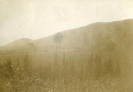
Photograph depicts dense undergrowth near the Bulkley River, mountains in the distance.
Photograph depicts dense undergrowth near the Bulkley River, mountains in the distance.
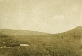
Photograph depicts bare mountain ridges near the Bulkley River and 55th parallel.
This item is a photograph of 575 Quebec Street, Prince George. Building is white, pink and blue. Telus tower can be seen in the background.
This item is a photograph of 575 Quebec Street, Prince George. Building is white, pink and blue. Telus tower can be seen in the background.
File contents relate to: Engineering. Document type(s) include: summary, blueprint.
File contents relate to: Engineering. Document type(s) include: summary, blueprint.
File contents relate to: Engineering. Document type(s) include: summary, blueprint.
Floppy label reads:
576
Land Reserve Commission
Working Farms, Working Forests
Floppy data failed migration.
File contents relate to: Engineering. Document type(s) include: summary, blueprint.
File contents relate to: Engineering. Document type(s) include: summary, blueprint.
This map depicts the generalized pit layout and estimated waste extraction areas for 5810 bench. Annotated details include numerical bench markers, extraction dates and approximate ore extraction amounts. The hand drawn plan consists of solid and dotted lines drawn with green, orange and lead pencil.
File contents relate to: Engineering. Document type(s) include: blueprint.
This map depicts the generalized pit layout and estimated waste extraction areas for benches 5840 and 5870. Annotated details include numerical bench markers as well as extraction dates. The hand drawn plan consists of solid and dotted lines drawn with green and red pencil.
This map depicts the pit layout and estimated waste extraction areas for 5840 bench for the end of September to November. Extraction dates, approximate extraction tonnages and ore, waste and talus locations are included throughout the plan. Annotated details include numerical bench markers, extraction dates, approximate total tonnages as well as waste and ore tonnage calculations for October. The hand drawn plan consists of solid and broken lines drawn with red, blue, orange and lead pencils as well as black ink.
This map depicts the pit layout and estimated waste extraction areas for 5870 bench for the end of August to November. Extraction dates, approximate extraction tonnages and ore, waste and talus locations are included throughout the plan. Annotated details include numerical bench markers, extraction dates, approximate extraction tonnages, ore, waste and talus locations as well as waste, ore, talus and total tonnage calculations for October. The hand drawn plan consists of solid and broken lines drawn with red, blue, orange and lead pencils as well as black ink.
File consists of notes and reproductions relating to the 5th and 6th Dukes of Sutherland.
The item is a photograph depicting 5th Avenue looking West from Vancouver Street. Annotations on the back states, "Monday 11:00 am - 29 Apr. /91 5th Ave looking W. from Vanc."
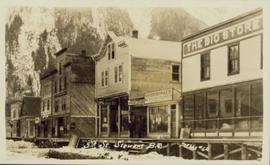
Photograph is a printed postcard depicting several lumber buildings in a row with a board walk in front. Signs include "s. Harrison & Co." and "The Big Store". There are steep mountains in the background printed annotation on recto reads "5th Street Stewart B.C."
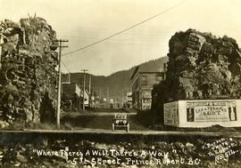
Handwritten annotation on recto of postcard reads: “Were there’s a will there’s a way, 5th Street, Prince Rupert, B.C., F. Button photo Pr. Rupert. No. 514.” Handwritten annotation in pen on verso of postcard reads: “Miss Belding, 33 Marlbro Avenue, Hull Yorkshire, England. S.S. Prince George. Dec. 1918. Dear Bertha, This is a street in the centre of the town Prince Rupert. There is a capacity list of passengers on board. The boat is registered to hold 384. We left at midnight and exped to arrive in Vancouver tomorrow at 3:30 pm. Love from Edie.”
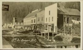
Street view photograph of the construction of 5th Street in Stewart, BC. Visible businesses include the "Hotel King Edward" and "Empress Theatre." Printed annotation on recto reads: "5th St. Stewart B.C. Hughes #46."
Plan depicts sections, elevations, and floor plans for the addition to the Kamloops roundhouse.
Plan depicts "scheme B" of the proposed 6 stall addition to the roundhouse at Kamloops, BC.
Architectural block plan depicts a proposed addition to the CNR roundhouse in Kamloops.
File contains a video recording of a 60 Minutes show of M. Moore on Euclid.
"Northwest Territories 60th Parallel" sign along the highway
This map depicts the generalized pit layout and estimated waste extraction areas for 6290 bench for the month of November. Annotated details include numerical bench markers and waste extraction dates. The hand drawn plan consists of solid and dotted lines drawn with green, orange, red, blue and lead pencil.
This map depicts the generalized pit layout and estimated waste extraction areas for 6290 bench for the month of October and November. Extraction dates as well as total unbroken tonnages are included within certain portions of the plan. Annotated details include numerical bench markers, extraction dates, total tonnages to be extracted and approximate waste tonnage calculations for October. The hand drawn plan consists of solid and broken lines drawn with red, green, orange and lead pencils as well as black ink.
This map depicts the pit layout and estimated waste extraction areas for 6320 bench. Extraction dates accompanied by its total tonnages are located within each planned area. Certain extraction dates are labeled with bench numbers. Annotated details include extraction dates, approximate total tonnages per area accompanied by extraction dates, total planned tonnages, total tonnages from December 31, 1971 as well as a rough colored legend depicting extraction month by color. The hand drawn plan consists of solid lines drawn with green, red, orange and lead pencils.
This map depicts the pit layout and estimated waste extraction areas for 6320 bench for the end of September to October. Extraction dates are included within certain portions of the plan. Annotated details include numerical bench markers, extraction dates, and approximate waste tonnage calculation for October. The hand drawn plan consists of solid and broken lines drawn with red, orange and lead pencils as well as black ink.
This map depicts the pit layout and estimated waste extraction areas for 6350 bench. Extraction dates accompanied by its total tonnages are located within each planned area. Annotated details include extraction dates, approximate total tonnages per area as well as extraction dates, total planned and broken tonnages and total tonnages from December 31, 1970 from a survey done in September 30. The hand drawn plan consists of solid lines drawn with red, green and orange colored pencils.
This map depicts the pit layout and estimated waste extraction areas for 6380 bench. Extraction dates accompanied by its total tonnages are located within each planned area. Certain extraction dates are labeled with bench numbers. Annotated details include extraction dates, approximate total tonnages per area as well as extraction dates, total planned and broken tonnages, total tonnages from December 31, 1970 from a survey done in September 1, numerical bench markers as well as a rough colored legend depicting extraction month by color. The hand drawn plan consists of solid lines drawn with green, yellow, red and lead pencils.
This map depicts the pit layout and estimated waste extraction areas for 6410 bench. Extraction dates accompanied by its total tonnages are located within each planned area. Certain extraction dates are labeled with bench numbers. Annotated details include extraction dates, approximate total tonnages per area as well as extraction dates, total planned and broken tonnages, total tonnages from December 31, 1970 and numerical bench markers. The hand drawn plan consists of solid lines drawn with green, yellow, orange and lead pencils.
This map depicts a drawn bench plan for the estimated excavated waste for bench 6440 during the first quarter of 1972. Annotated details include the approximate excavated ore tonnages, broken and planned values for the first quarter and revised calculations from previous years values. Planned excavated areas are drawn with different colors.
