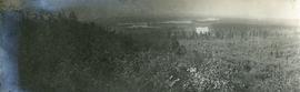
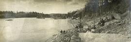
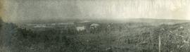
Imprimir vista previa Cerrar

Mostrando 321 resultados

Archival description
286 resultados con objetos digitales Muestra los resultados con objetos digitales
Drying sugar
2014.10.1.104 · Item · 1910
Parte de Arthur Holland Land Surveying Collection

Photograph depicts a tarp spread out on the grass, two men sit nearby the tarp. There is a canvas tent in the background with a man standing beside it. Behind the tent is a low hill with a fence bordering the top of the hill. There are blankets drying on the fence.

Lheidli T'enneh Village
2014.10.1.054 · Item · 1909
Parte de Arthur Holland Land Surveying Collection

Photograph depicts a cluster of wooden buildings including a flagpole and church spire at a Lheidli T'enneh village site. Original photo identified this image as "Indian Village, Fort George".

East Line
2012.13.2.17 · Sub-séries · 1972-2011
Parte de J. Kent Sedgwick fonds

Subseries consists of material collected by Kent Sedgwick for research regarding the communities along the East Line of the Grand Trunk Pacific Railway in Central British Columbia, particularly between Prince George and McBride. These communities and locations include, among others, Shelley, Willow River, Sinclair Mills, Longworth, Dunster, Tete Jaune, Valemount, Mount Robson, and the Yellowhead Pass. Research on these communities was conducted during Kent Sedgwick's involvement in the UNBC-led Upper Fraser Historical Geography Project. The files primarily consist of research notes, audio and transcripts of oral interviews, and photographs of the East Line communities.

Parks and Outdoor Recreation
2012.13.2.14 · Sub-séries · 1970-2011
Parte de J. Kent Sedgwick fonds

Subseries consists of material collected and created by Kent Sedgwick for research regarding parks and outdoor recreation in Prince George. Material on parks includes Fort George Park (renamed to Lheidli T’enneh Memorial Park in 2015); Cottonwood Island Park; Connaught Hill; Moore's Meadow; L.C. Gunn Park; the Nechako Cutbanks; Paddlewheel Park; Monkman Provincial Park; Fraser Canyon Park; and Carp Lake. Also includes information on the creation of plaques and monuments, including the Alexander Mackenzie monument; the “Arrival of Steel” CN railway plaque; heritage interpretative signs for the Grand Trunk Pacific Railway; the Millar addition; and flooding and rivers. The files consists of various pamphlets and correspondence regarding the development of parks and the creation of interpretive materials.

Geography and Natural Resources
2012.13.2.11 · Sub-séries · 1937-2011
Parte de J. Kent Sedgwick fonds

Subseries consists of materials collected by Kent Sedgwick for research on the geography and natural resources in Prince George and its region. Includes material on the natural resource industry, including the opening of the McArthur Sawmill, the W. Lamb and Sons Lumber Sawmill, and mining; photocopied aerial photographs of Prince George; the climate, temperatures, and flooding; and the geographical features of Prince George.

City of Prince George
2012.13.2.01.03.3 · Item · [after 1970]
Parte de J. Kent Sedgwick fonds

Map depicts the city of Prince George with annotations of the boundary expansions from 1915 to 1964.

Research Subject Files
2012.13.2 · Séries · 1937-2011
Parte de J. Kent Sedgwick fonds

Kent Sedgwick’s research subject files contain original research notes, interviews and oral histories, news clippings, and collected primary and secondary sources. The series also includes both original and reproduction photographs, audio recordings, and maps. The subject files primarily relate to the history, urban planning, and historical geography of the Central Interior of British Columbia, especially Prince George area and the East Line communities over the course of the 20th century. They also include extensive notes on geographic features, landscapes, interpretative trails, architectural history, industrial history, history of Western exploration and land survey, and the First Nations history of the region.

Paddlewheel Park
2012.13.1.7.202 · Item · Nov. 2000
Parte de J. Kent Sedgwick fonds

Image depicts the Fraser River at Paddlewheel park, with a train on the other side of the river, in Prince George B.C.

Paddlewheel Park
2012.13.1.7.201 · Item · Nov. 2000
Parte de J. Kent Sedgwick fonds

Image depicts the Fraser River at Paddlewheel park, with a train on the other side of the river, in Prince George B.C.

Prince George
2012.13.1.7.195 · Item · Nov. 2000
Parte de J. Kent Sedgwick fonds

Image depicts Prince George with numerous trees obscuring most of the view.

Bridge
2012.13.1.7.165 · Item · 12 Oct. 1989
Parte de J. Kent Sedgwick fonds

Image depicts a bridge in Prince George, B.C.

Bridge
2012.13.1.7.164 · Item · 12 Oct. 1989
Parte de J. Kent Sedgwick fonds

Image depicts a bridge in Prince George, B.C.

Bridge
2012.13.1.7.163 · Item · June 1986
Parte de J. Kent Sedgwick fonds

Image depicts a bridge in Prince George, B.C.