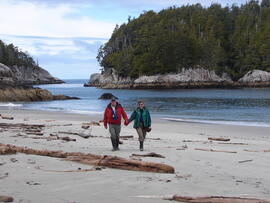
Photograph depicts Gary Runka and Joan Sawicki on a BC central coast beach.
Photograph depicts a CN locomotive numbered 2693 with trees along both sides of the railway tracks.
Photograph depicts the Blue river store in the North Thompson region.
Photograph depicts the Ambulance service building in the North Thompson region.
Photograph depicts Businesses in downtown in the North Thompson region, including a sign reading "Welcome to historic George Street" and Levi's jeans store.
Photograph depicts dirt tracks in a field in front of a body of water.
Photograph depicts a residential building in the North Thompson region. The house is blue and surrounded by trees.
Photograph depicts the Soda Creek cemetery.
Photograph depicts an octagonal railway water tower at an unknown location.
Photograph depicts a wooden building presumably at the Fort St. James historic site.
Photograph depicts a wooden building, presumably at the Fort St. James historic site.
Photograph depicts an abandoned and worn out wooden building in a flat field.
The item is a map that depicts subdivision lots along the Fraser River in Prince George. The subdivision is DL 745 and 747 of the Cariboo District. Map is certified by G. F. Templeton, a BC land surveyor.
Photograph depicts a section of railway trackage, presumed to be located within or nearby Sinclair Mills, BC.
Photograph depicts a section of railway trackage, presumed to be located within or nearby Sinclair Mills, BC. There is a man on the other side of the railway tracks.
Photograph depicts a post office, presumably in Sinclair Mills.
Photograph depicting a large stone surrounded by trees in an unknown location.
Photograph depicting a landscape with a lake and a mountain in the background.
Photograph depicting a large stone surrounded by trees and two people sitting on top of it.
Photograph depicting a log house, presumably in the campground in Quesnelle Forks.
Photograph depicting a small log cabin with a front porch and a sign reading "Happy 150th Anniversary Cariboo Gold Rush 1859-2009", presumably taken in Quesnelle Forks.
Videotape contains footage of: 14-Jan-10 - Green Day
The photograph depicts twin train tracks near Finmoore, B.C. in the summer.
The photograph depicts Barry McKinnon standing next to a stack of railroad ties near Finmoore, B.C. in the summer. Annotation on reverse side of photograph states, "Finmoore 2010, Barry McKinnon."
The photograph depicts the Goat River railway station next to twinned rails. The station is abandoned with missing doors and windows. Annotation on card states, "GOAT RIVER RAILWAY STATION." Photograph is a reproduction from [ca. 1978].
The item is a photograph depicting a boat with multiple people going down the Quesnel River.
The item is a photograph depicting a person walking among three abandoned cabins at Quesnel Forks.
DVD disc contains two documents:
- "KCB Design Update for L-L Dam Crest Elevation 1279 m.pdf"
- "Piteau 2605-R02-FINAL_Revised_Sep2010.pdf" which is a Piteau Associates report for the Highland Valley Copper mine at Logan Lake regarding "Open Pit Geotechnical Assessments and Slope Design Criteria for the Lornex Pit L16 Expansion"
Document is a research installation layout map for the Kenneth Creek site of the Sulphur stable isotope tracer study (E.P. 886.15).
The item is a photograph depicting North Road camp for Sinclair Mills looking North. Annotation on reverse side of photograph states, "North Rd camp 2010, looking N."
Item is a UNBC strategic plan titled: UNBC "The University Plan", 2010.
Videotape contains footage of: Feb-10 - Basketball - 21-Mar-12 - Brian Woolf regarding research in Prophet River
The item is a CD-R containing various jpg. photographs and a PowerPoint presentation about the Grand Trunk Pacific Railway done by Kent Sedgewick.
The photograph depicts the Goat River railway station next to twinned rails. The station is abandoned with missing doors and windows. Annotation on reverse side of photograph states, "Goat River GTP Station c. 1978 maybe 1982. photo by J. Kent Sedgwick." The statement, "Geo Info Services" is crossed out. Photograph is a reproduction from [ca. 1978].
The item is a photograph depicting a cabin at Quesnel Forks.
The item is a microcassette containing an oral interview follow up with Janet Kozak.
Photograph depicts a section of railway trackage, presumed to be located within or nearby Sinclair Mills, BC.
Photograph depicts a section of railway trackage, presumed to be located within or nearby Sinclair Mills, BC with an old truck parked beside the tracks and the forest.
Photograph depicts an open field surrounded by trees.
Photograph depicts a landscape, with mountains in the background and trees in the foreground.
Photograph depicting a residential building surrounded by trees in an unknown location.
Item is an original copy of the 2010 "Review of the Agricultural Land Commission - Moving Forward: A Strategic Vision of the Agricultural Land Commission for Future Generations" submitted by Richard Bullock, Chair of the Provincial Agricultural Land Commission.
The item is one audiocassette containing a copy of an interview with Janet Kozak regarding the L'heidli T'enneh cemetery. Annotations on the case state, "Janet Kozak re: native cemetery 20 Apr/2010 COPY"
Photograph depicts a section of railway trackage with a pile of locks stacked beside the rail line, presumed to be located within or nearby Sinclair Mills, BC.
Photograph depicts the Sinclair Mills community hall, it includes a sign in front of the building reading "Welcome to Sinclair Mills, Community Hall".
Photograph depicts an open field and a dirt road surrounded by trees in an unknown location.
Photograph depicting a campground with log cabins and an open field surrounded by trees, presumably in Quesnelle Forks.