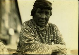
Skeena River running through rocky cliffsides, Northern British Columbia
Photo depicts a street perspective cars lining Third Avenue, in Prince George, BC, ca. 1950. Annotation recto reads: "3rd Ave Prince George BC Photo J. Wrathall." Handwritten annotation in pen on verso of postcard reads: “This is the equivalent of our Granville Street. Both theatres are located here as well as Hudson Bay Co., banks, library & stores.”
Elevated view of Third Avenue in Prince Rupert. Several cars and delivery trucks are visible driving along the road. Printed annotation on recto reads: "3rd Ave Prince Rupert BC Photo by Wrathalls."
Photograph depicts two cars with their front ends welded back-to-back.
Street view photograph looking down Carson Avenue at the Front St. intersection in Quesnel, BC. Several identified businesses line the gravel avenue on the right; however Cowan's Hardware store is visible at the intersection on the left. Printed annotation on recto reads: "Carson Ave., Quesnel, B.C. 1930 Looking East."
The item depicts plans for the interior basement, main floor, second floor and the roof of the Carter House at 1850 10th Avenue, Prince George. Original plans drafted in April 1979 and approved by the city and stamped on 1 June 1979. Annotations include notations regarding scale and other measurements.
The item depicts plans for the exterior, longitudinal and transverse sections of the Carter house at 1850 10th Avenue, Prince George.
Image depicts the Carter Industrial Area in Prince George, B.C.
The Cartographic Materials series consists of maps, plans, schematics and blueprints documenting a wide variety of subject areas pertaining to both the operation of the Cassiar Asbestos Corporation Ltd., and the company township of Cassiar, B.C.
Cassiar Asbestos Corporation Ltd.Subseries consists of cartographic material separated from Campagnolo’s government textual record files. Includes government maps of British Columbia created by the Department of Energy, Mines and Resources Surveys and Mapping Branch; tourist road maps of BC, Prince Edward Island, Corner Brook, and Regina; maps relating to the oil and gas industry; maps of site plans for proposed developments; and a map of Edmonton for the XI Commonwealth Games.
Series consists of two maps: one related to the traveled route of the surveyors of the Bedaux Sub-Artic Expedition in 1934; and the other related to a goldmine and a hotel in Africa.
Maps within this series document the placer streams, islands and harbours of the Queen Charlotte Islands; as well as the mining properties located within the vicinity of Stewart, BC.
Carvings sit among bushes in front of what appears to be a totem pole.
Handwritten annotation on verso reads: "Eagle & whale Monument Tanu".
Carved stone figure on left features a hole at one end through which a rope is strung; while the figure on the right is a soapstone figure carving of a face with two ears to the sides and split ‘u’ ones at the top of the head. Handwritten annotation in pen on verso reads: “W.E. Collison.” Stamped annotation on verso reads: “Department of Mines and Resources, Photographic Section. Oct. 6, 1939”. Numeric annotation on verso: “51-5”
Carved wooden sculpture of a seated male figure - his hands on his chest wearing a headdress and a neck ring. Stamped annotation on verso reads: “Department of Mines and Resources, Photographic Section. Oct. 6, 1939”. Numeric annotation on verso: “46-3”.
An unidentified carved wooden tool or utensil with twine attached, leans against a sheet covered wall behind a carved wooden platter. Stamped annotation on verso reads: “Department of Mines and Resources, Photographic Section. Oct. 6, 1939”. Numeric annotation on verso: “50-3”
Image depicts several unidentified individuals inside a building, one of which is carving a totem pole. The location is uncertain.
Photograph depicts a carving at the entrance to Little Qualicum Falls Park on the Alberni Highway. On the left side is the face of a white settler.
This Inuit carving is of an arctic mammal, possibly an otter, with a mounted brass plate with the inscription "Canada Cup 1976." This carving was a gift to Minister Iona Campagnolo from the Canada Cup yacht racing event.
Photograph depicts a section of white water along the Cascade River. Annotation on versio: "August (?), Cassiar, Cascade River, A.H. Phipps".
File contents relate to: Engineering. Document type(s) include: summary. Notes: includes handwritten summary of costs.
File consists of a conference paper by Weller titled "Cascadia: Regional Trade and Separatist Politics." This file was originally numbered to correspond with conference paper number 87 listed in Weller's CV.
File consists of Canadian Technical Report of Fisheries and Aquatic Sciences No. 1477 entitled "Case Histories of Regulated Stream Flow and its Effects on Salmonid Populations" by D.W. Burt and J.H. Mundie.
File consists of a published copy of Burt and Mundie's Canadian Technical Report of Fisheries and Aquatic Sciences report entitled "Case Histories of Regulated Stream Flow and its Effects on Salmonid Populations". Includes accompanying correspondence related to the publication.
Photograph depicts a case traction engine that was built in 1913. Displayed at the Abbotsford Agricultural Fair.
Photograph depicts a case traction engine that was built in 1915 located at Three Valley Gap Motel, some 15 miles west of Revelstoke. It is steamed for a few days each year and was used continuously to 1959 by Mr. Dale of Saskatchewan.
Photograph depicts a case traction engine that was built in 1915. It steamed for a few days each year and was used continuously to 1959 by Mr. Dale of Saskatchewan.
Videocassette contains footage regarding CASHS and First Nations recruitment.
File consists of photographs of the CASHS Awards Ceremony for 2002 / 2003.
View of snow capped mountains in the distance, vast rolling treed hills in mid ground and a gravel road in the foreground. Road sign indicating severe curve in road situated at the right of the gravel road. Handwritten annotation on verso in pen reads: “Cassiar – Stewart highway”
Photograph depicts the Cassiar town in foreground, mine valley and north mountain range in background. Photograph speculated to have been taken during the plane ride of an outside exploration trip.
Photograph depicts the Cassiar mine valley in north mountain range. Plant and tailings pile can be seen in right foreground, and the east end of the town is visible in left foreground. Photograph speculated to have been taken during the plane ride of an outside exploration trip.
Photographs depict aerial views of the Cassiar townsite, plantsite, tailings pile, mine road, bench and pit mine, mine buildings (tramline loading station, crusher, shop, and garage), and surrounding mountain range. Here "aerial" refers to photos depicting a large area and taken from the air or from a high point of elevation.
Photograph depicts the Cassiar valley, showing the east end of town in foreground. Plant and tailings pile can be seen in right midground. Photograph speculated to have been taken during the plane ride of an outside exploration trip.
File contents relate to: Accounting / Payroll. Document type(s) include: account book.
File contents relate to: Accounting / Payroll. Document type(s) include: invoices. Notes: Miscellaneous invoices.
A set of 13 maps showing approximate waste extraction areas for different benches during certain months of 1972. Extraction dates are included accompanied by estimated total tonnages for each planned extraction area. All plans are hand drawn using colored pencils, lead and black ink. Approximate calculations of extraction tonnages are included within certain months. Numerical bench markers are included. Total tonnages from the previous year and previous surveys are included within certain plans.
File contents relate to: Accounting / Payroll, Cassiar Mine - operation and administration. Document type(s) include: report.
File contents relate to: Accounting / Payroll, Cassiar Mine - operation and administration. Document type(s) include: report. Notes: 2 copies.
File contents relate to: Accounting / Payroll, Cassiar Mine - operation and administration. Document type(s) include: report.
File contents relate to: Cassiar Mine - operation and administration. Document type(s) include: report.
Fonds consists of textual, photographic, cartographic, electronic and promotional films/video recordings related to the mining operations of Cassiar Asbestos Mining Corporation (CAMC) and creation of Cassiar townsite. CAMC records primarily consist of records related to mining operations including construction, engineering, daily mining operations, administration of CAMC, tallies of extractions, labour and union activities, corporate events and visits by dignitaries. Townsite records are primarily visual representations of townsite construction, including the creation of health, education and community services including Cassiar's private hospital, school, library, as well as townsite images. Photographs include documentation of natural and man-made landscapes within the Cassiar region of Northern BC. Other holdings include a near complete run of Cassiar's community newspaper.
Cassiar Asbestos Corporation Ltd.Photograph depicts the Cassiar Asbestos Corporation's warehouse on Pier 94.