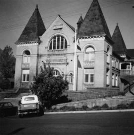
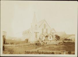
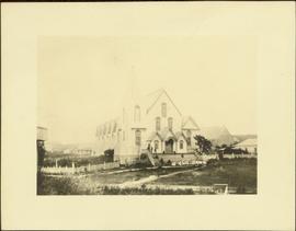
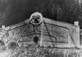
Image depicts the Prince George Civic Centre.
Photograph depicts the city hall in Rossland, B.C. built in 1990, during its heyday.
Photograph depicts the city hall in Pitt Meadows in the Fraser Valley.
Photograph depicts the city hall at New Westminster on Victoria Day. The anvil battery is about to fire a 21 gun salute.
Photograph depicts the city hall at New Westminster on Victoria Day. The anvil battery firing round #3 of 21 gun salute.
Image depicts City Hall in Prince George, B.C.
Image depicts Prince George City Hall. Map coordinates 53°54'46.3"N 122°44'41.9"W
Photograph depicts the Chute depot at mile 106.5 on the CPR line in the Carmi Subdivision. It is a totally isolated location, but not reachable by road. The photo shows the only surviving large building. The rail here is dated 1942.
Photograph depicts one of the churches on Denman Island.
Photograph depicts a church or school on the south side of Craigflower Rd. in Victoria B.C. It is near or on the Songhees Reserve.
Photograph depicts a church that was built of shaped logs on the territory of the Tsal'alh Nation on the road leading to Seton Lake. Church was derelict, but still held pews, plastic flowers and small shrines.
Photograph depicts a church on a reservation at Mosquito Creek in North Vancouver, B.C.
Image depicts a church on a hill somewhere in Seton Portage, B.C.
Photograph depicts the church of His Presence in Halfmoon Bay, Sechelt. It was built in 1962 by Cannon Greene, a former seafaring minister of the Columbia Coast Missions and the subject of a C.B.C. T.V. production in early April 1966.
Image depicts a church located near Mapes, B.C.
Image depicts the interior of a church, possibly one in or near Barkerville, B.C.
Image depicts the interior of a church, likely in Fort St. James, B.C.
Photograph depicts a church on River Road, Whonnock, Maple Ridge.
Photograph depicts a church on Wood St. in Greenwood, which is between Oliver and Grand Forks. The church may have been Roman Catholic.
Photograph depicts a church in Arrow Park on Arrow Lakes in southeastern B.C.
Photograph depicts a church built in 1876 in Nicola, 7 miles northeast of Merritt. It was originally a Presbyterian church and is one of the oldest in the interior, though it is now infrequently used.
Photo of church door with spire, front door and picket fence. Handwritten annotation in pencil on recto reads: “Port Essington B. C.”
Photograph depicts two men standing in street at the Fort George Reserve. A church with steeple stands in midground, on left side of street. Forest in background. Handwritten annotation on verso and recto of this photograph reads: "Fort George Temple." See item 2009.5.3.28 for photograph depicting this reserve which belonged to the Lheidli T'enneh Band.
Photograph depicts an unused church at Clayburn, near Abbotsford, B.C. The church and about half the buildings in the village are made of brick.
Photograph depicts large church in fenced area, mission house visible behind trees in background.
Printed on image: "The Church. Old Massett. Q.C.I. / J.D. Allen. Photo. C."
Image depicts the interior of a church, most likely St. Mark's Anglican Church in Woodpecker, B.C.
Image depicts a church, somewhere between Hazelton and Hagwilget, B.C.
Photograph depicts a Chinese farmer's buildings on the Port Guichon Rd. on the outskirts of Ladner, B.C.
Photograph depicts Chinatown in Duncan, B.C. on Vancouver Island.
Photograph depicts the Chinatown in Duncan on Vancouver Island.
Image depicts the Chimney Lake Lodge.
Image depicts Chimney lake with a number of houses near the shore, and a child in the foreground.
Image depicts a bridge over the Fraser River, located at Chimney Creek, somewhere south-west of Williams Lake, B.C.
Several unidentified individuals can be seen on front steps of church and a group of small children in white stand in line below steps. Other community buildings are visible in background, white fence crosses foreground. Photograph depicts the first church built in Metlakatla, which was burned in a fire in 1901, and replaced in 1903.
Handwritten annotation on verso reads: "Church (of England) at Metlakahtla - British Columbia. Built by the people of the village - largest church then on the pacific coast."
Several unidentified individuals can be seen on front steps of church and a group of small children in white stand in line below steps. Other community buildings are visible in background, white fence crosses foreground. Photograph depicts the first church built in Metlakatla, which was burned in a fire in 1901, and replaced in 1903.
Handwritten annotation on verso reads: "Old church at Metlakatla Before fire. Built by Fr. Duncan & the village people".
Seven young boys enjoying a game of tug-a-war alongside a wooden track. Track runs along a picket fence through a village. A small girl watches the fun from the sidelines and older woman carries a basket in the background. Handwritten annotation in pen on verso reads: “Native children at play”.
Image depicts two children standing near an old car in Island Cache.
Image depicts a sign titled "Chilcotin Wildlife Management Area" somewhere near Riske Creek, B.C. It reads: "This trail has been provided by the Fish and Wildlife Branch in co-operation with Riske Creek Ranching Ltd., as access to the Chilcotin Wildlife Management Area. Please do not leave the the trail as the surrounding land is private property."
Photograph depicts two men standing at base of totem pole in front of large elaborate lodge building with post reading "MINESQU". Smaller structure stands in background (elevated cache?).
Handwritten annotation on verso reads: "Chapter XXIV. No. 3. A chief's lodge and totem Nass River."
Two carved poles stand in foreground, a third smaller pole visible by wood structure in background.
The pole at left is the Chief Skedans mortuary pole, which was raised in the Haida village of Skidegate about 1870. It honours the Raven Chief of Skedans and depicts the chief's hereditary crests. The two tiny figures in the bear's ears are the chief's daughter and son-in-law who erected the pole and gave a potlach for the chief's memorial. The rectangle board at the top of the original pole covered a cavity that held the chief's remains.
The pole at left may be a whale pole.
Handwritten annotation on verso reads: "For heading of Page 12. Fin Back Whale Crest. [?] Totems, S.E. Alaska". This original annotation is believed to be incorrect.
Photograph depicts Chief Gold's house with a moon crest from 1884 at Second Beach, Skidegate and a short distance from the museum site.
Image depicts a view of a train passing through an area of Chetwynd, B.C.
Image depicts a number of townhouses in Chetwynd, B.C.
Image depicts a view of a saw mill in Chetwynd, B.C.
Image depicts several businesses in a small section of Chetwynd, B.C. There is a motor hotel and a half-visible sign for an Esso gas station.
Image depicts several houses in Chetwynd, B.C.
Image depicts a Chevron station as well as two motels in Chetwynd, B.C.