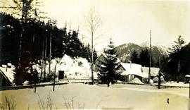
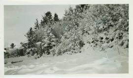
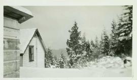
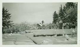
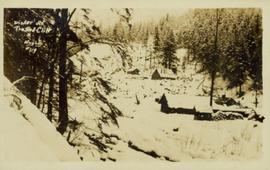
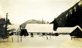
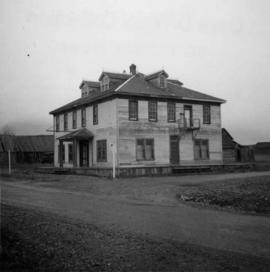
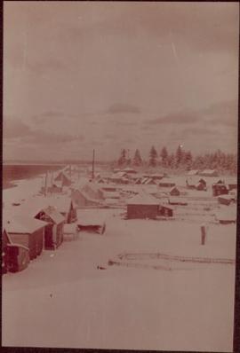
Photograph depicts village buildings along shore.
Handwritten annotation on verso reads: "Massett in Winter dress."
Photograph depicts village buildings along shore.
Handwritten annotation on verso reads: "Massett in Winter dress."
Photograph depicts deep snow in the foreground, fences and houses in the midground and snowy mountains in the background. Handwritten annotation below photograph reads, "Winter Dec/27 Naas Harbour, B.C.".
Handwritten annotation in pen on verso reads: “Looking out of our classroom window up the street.” According to the donor, the car stuck in the snow belonged to his colleague, Bob White.
Photograph depicts two people and a dog team on a snowy river bank with a narrow passage of open water and a snowy bluff in the background.
Elevated photograph of downtown Prince Rupert covered in snow. Printed annotation on recto reads: "Winter Scene. Prince Rupert. B.C."
File consists of a speech given by Gary Runka entitled "Winter Range for Ungulates" for the Symposium on Threatened Species and Habitats in British Columbia and the Yukon.
Partially visible handwritten annotation on verso: "...this wall is only a few feet thick, but runs out for a long distance on both sides of the river."
Snow covered landscape in Queen Charlotte City. Handwritten annotation on verso reads: "Queen Charlotte Island Christmas 1946."
Railroad track, utility poles, field, small building and background hills are visible in image.
Photograph is an aerial (?) perspective of a mountaineous area and a valley both covered with snow.
Partial buildings are visible amongst the snow topped trees. Mountains visible in the background. Handwritten annotation on verso reads: "Queen Charlotte Island Christmas 1946."
Snow covered buildings, hedges and boardwalk in Queen Charlotte City. Handwritten annotation on verso reads: "Queen Charlotte Island Christmas 1946."
Photograph depicts a four-dog team harnessed to a loaded sleigh. Two people stand near the loaded sleigh on a snowy forest path.
Photograph is a printed postcard depicting a few cabins covered in snow near Stewart B.C.
Photograph depicts a snowy foreground, simple houses in the midground and snowy mountains in the background. Handwritten annotation below photograph reads, "Winter at Naas Dec. 1927".
Photograph depicts Iona Campagnolo posing with the unidentified winning rafting team of the Kitimat Delta King Days raft race event. All of the men are hold trophies, and many wear decorative hats.
Photograph depicts Windsor School, an elementary school in south Burnaby.
Photograph depicts Windsor Hotel, the only survivor of about 5 hotels that were in the area.
Photograph depicts the Windsor Hotel at Fort Steele, 10 miles northeast of Cranbrook. It was built in 1895 by Robert D. Mather and originally was called Dalgarno House. It is being renovated as a village museum.
Photograph depicts numerous copies of 'Stoney Creek Woman' (by Bridget Moran) in glass case. Display also features article on Mary John's receipt of the Order of Canada (see items 2008.3.1.22.61 and 2008.3.1.22.64 for photographs displayed in this image).
Photograph depictsa small windmill in the yard of a home.
Photograph depicts a windlass over a shallow well used for cattle water supply. Found 1 mile north of the USA/Canadian border, south of Langley and north of Blaine.
Photograph depicts trees on a hillside. Handwritten annotation below photograph reads, "wind effect on trees".
Caption describing photograph: "Typical of wetter ground of lacustrine deposits, originally willow and alder with scattered low quality conifer col (spruce). (Skunk Cabbage) (Urtica) (A-D) 1922 burn Giscome. Definitely higher use is grazing or forage prod."
Image depicts a snowy street in Willow River, B.C. There are several buildings, one is an Esso station and another is labelled as "Red & White Food Store."
Image depicts a snowy street in Willow River, B.C. with a row of houses. The white building on the end with the Pepsi sign is the Willow River General Store. Map coordinates 54°04'18.3"N 122°28'14.7"W
Image depicts the Willow River General Store. Map coordinates 54°04'23.7"N 122°28'26.9"W
Image depicts a playground in Willow River, B.C. The slide labels it as being a "former hotel site." Map coordinates 54°04'23.7"N 122°28'26.9"W
Image depicts a group of people somewhere in Willow River, B.C. The man in the plaid shirt and beige cap is identified on the slide as being Lloyd Edwards.
Image depicts the cableway in Willow River, B.C.
Image depicts the cableway, stretching over a river, in Willow River, B.C.
Image depicts the cableway in Willow River, B.C.
Photograph taken on the Williams Lake to Bella Coola road.
Caption: Williams Lake Stampede, caribou country. Speed? Note the open country; semi dry belt. Item is a blurred photograph of a man on horse back.
Digitized video clip of silent film footage depicts the Williams Lake Stampede and a parade.
Caption: Williams Lake Stampede, caribou country. Most of the horses aren't much for looks, but they have other qualities. Item is a photograph of four boys (?) on horseback standing in a parking lot.
Image depicts the St. Joseph's Mission in Williams Lake, B.C.
Image depicts an aerial view of Williams Lake, B.C.
Image depicts a view of Williams Lake, B.C.
Image depicts an aerial view of Williams Lake, B.C.
Photograph depicts a man wearing rubber boots, standing on a board walk, a house in the background. Handwritten annotation below photograph reads, "Sweet Wm Smith".