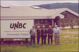
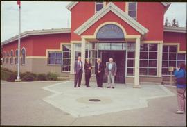
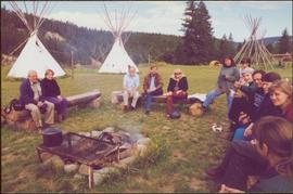
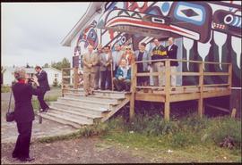
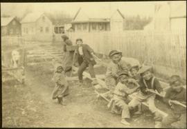
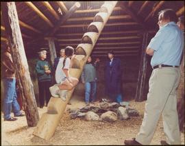
Unidentified women stands in centre background with arm raised, and a young girl sits on post in foreground. Photograph was taken during the chancellor's tour of Xats'ull Heritage Village, Soda Creek First Nation, Williams Lake, B.C.
Chancellor Campagnolo stands with Chetwynd Mayor Charlie Lasser, President Geoffrey Weller, an unidentified man, and Fred Gilbert. Photograph was taken during the chancellor's tour of the Peace-Liard Region, 1993.
Handwritten annotation on verso reads: "chetwynd".
Chancellor Campagnolo stands with man believed to be the mayor of Tumbler Ridge, President Geoffrey Weller, and Dean Fred Gilbert. Photograph was taken during the chancellor's tour of the Peace-Liard Region, 1993.
Left to right: Charles Jago and unidentified woman, David Fish, Dennis Macknak, Deborah Poff, unidentified woman and child, Iona Campagnolo, Lee Morrison, Ellen Facey, two unidentified women. Teepees visible in background. Photograph was taken during the chancellor's tour of Xats'ull Heritage Village, Soda Creek First Nation, Williams Lake, B.C.
Group features Charles Jago, Mike Hammar, Jacob McKay, Bert McKay, Deborah Poff, Alex Michalos, Dennis Macknak, Margaret Anderson, David Fish, Dean Doug Nord, Fred Beil, and Chancellor Iona Campagnolo. Photograph was taken during the chancellor's tour of Nass Valley, ca. 1992.
Group features Charles Jago, Mike Hammar, Jacob McKay, Bert McKay, Deborah Poff, Alex Michalos, Dennis Macknak, Margaret Anderson, David Fish, Dean Doug Nord, and Fred Beil. Photograph was taken during the chancellor's tour of Nass Valley, ca. 1992.
Chancellor Campagnolo stands with five unidentified Quick Start students, Fred Gilbert, and Nick Petraryszak. Photograph was taken during the chancellor's tour of the Peace-Liard Region, 1993.
Photograph depicts four men standing near fully packed horse-drawn cart in front of wood buildings, including a long building with a porch and chairs. Trees on hill visible in background. Handwritten annotation on recto of photograph: "Changing teams on the Cariboo Road".
Interior photograph of a church. Printed annotation on recto reads: “Chapel, Indian school, Fraser Lake B.C.”
Image depicts a view of Chetwynd, possibly from Highway 97.
Image depicts a Chevron station as well as two motels in Chetwynd, B.C.
Image depicts several houses in Chetwynd, B.C.
Image depicts several businesses in a small section of Chetwynd, B.C. There is a motor hotel and a half-visible sign for an Esso gas station.
Image depicts a view of a saw mill in Chetwynd, B.C.
Image depicts a number of townhouses in Chetwynd, B.C.
Image depicts a view of a train passing through an area of Chetwynd, B.C.
Photograph depicts Chief Gold's house with a moon crest from 1884 at Second Beach, Skidegate and a short distance from the museum site.
Two carved poles stand in foreground, a third smaller pole visible by wood structure in background.
The pole at left is the Chief Skedans mortuary pole, which was raised in the Haida village of Skidegate about 1870. It honours the Raven Chief of Skedans and depicts the chief's hereditary crests. The two tiny figures in the bear's ears are the chief's daughter and son-in-law who erected the pole and gave a potlach for the chief's memorial. The rectangle board at the top of the original pole covered a cavity that held the chief's remains.
The pole at left may be a whale pole.
Handwritten annotation on verso reads: "For heading of Page 12. Fin Back Whale Crest. [?] Totems, S.E. Alaska". This original annotation is believed to be incorrect.
Photograph depicts two men standing at base of totem pole in front of large elaborate lodge building with post reading "MINESQU". Smaller structure stands in background (elevated cache?).
Handwritten annotation on verso reads: "Chapter XXIV. No. 3. A chief's lodge and totem Nass River."
Image depicts a sign titled "Chilcotin Wildlife Management Area" somewhere near Riske Creek, B.C. It reads: "This trail has been provided by the Fish and Wildlife Branch in co-operation with Riske Creek Ranching Ltd., as access to the Chilcotin Wildlife Management Area. Please do not leave the the trail as the surrounding land is private property."
Image depicts two children standing near an old car in Island Cache.
Seven young boys enjoying a game of tug-a-war alongside a wooden track. Track runs along a picket fence through a village. A small girl watches the fun from the sidelines and older woman carries a basket in the background. Handwritten annotation in pen on verso reads: “Native children at play”.
Several unidentified individuals can be seen on front steps of church and a group of small children in white stand in line below steps. Other community buildings are visible in background, white fence crosses foreground. Photograph depicts the first church built in Metlakatla, which was burned in a fire in 1901, and replaced in 1903.
Handwritten annotation on verso reads: "Church (of England) at Metlakahtla - British Columbia. Built by the people of the village - largest church then on the pacific coast."
Several unidentified individuals can be seen on front steps of church and a group of small children in white stand in line below steps. Other community buildings are visible in background, white fence crosses foreground. Photograph depicts the first church built in Metlakatla, which was burned in a fire in 1901, and replaced in 1903.
Handwritten annotation on verso reads: "Old church at Metlakatla Before fire. Built by Fr. Duncan & the village people".
Image depicts a bridge over the Fraser River, located at Chimney Creek, somewhere south-west of Williams Lake, B.C.
Image depicts Chimney lake with a number of houses near the shore, and a child in the foreground.
Image depicts the Chimney Lake Lodge.
Photograph depicts Chinatown in Duncan, B.C. on Vancouver Island.
Photograph depicts the Chinatown in Duncan on Vancouver Island.
Photograph depicts a Chinese farmer's buildings on the Port Guichon Rd. on the outskirts of Ladner, B.C.
Image depicts a church, somewhere between Hazelton and Hagwilget, B.C.
Image depicts the interior of a church, most likely St. Mark's Anglican Church in Woodpecker, B.C.
Photograph depicts large church in fenced area, mission house visible behind trees in background.
Printed on image: "The Church. Old Massett. Q.C.I. / J.D. Allen. Photo. C."
Photograph depicts an unused church at Clayburn, near Abbotsford, B.C. The church and about half the buildings in the village are made of brick.
Photograph depicts two men standing in street at the Fort George Reserve. A church with steeple stands in midground, on left side of street. Forest in background. Handwritten annotation on verso and recto of this photograph reads: "Fort George Temple." See item 2009.5.3.28 for photograph depicting this reserve which belonged to the Lheidli T'enneh Band.
Photo of church door with spire, front door and picket fence. Handwritten annotation in pencil on recto reads: “Port Essington B. C.”
Photograph depicts a church built in 1876 in Nicola, 7 miles northeast of Merritt. It was originally a Presbyterian church and is one of the oldest in the interior, though it is now infrequently used.
Photograph depicts a church in Arrow Park on Arrow Lakes in southeastern B.C.
Photograph depicts a church on Wood St. in Greenwood, which is between Oliver and Grand Forks. The church may have been Roman Catholic.
Photograph depicts a church on River Road, Whonnock, Maple Ridge.
Image depicts the interior of a church, possibly one in or near Barkerville, B.C.
Image depicts the interior of a church, likely in Fort St. James, B.C.
Image depicts a church located near Mapes, B.C.
Photograph depicts the church of His Presence in Halfmoon Bay, Sechelt. It was built in 1962 by Cannon Greene, a former seafaring minister of the Columbia Coast Missions and the subject of a C.B.C. T.V. production in early April 1966.
Image depicts a church on a hill somewhere in Seton Portage, B.C.
Photograph depicts a church on a reservation at Mosquito Creek in North Vancouver, B.C.