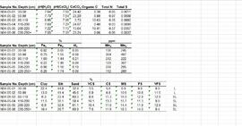
Subseries consists of records relating to personnel and human resources issues that were created or accumulated by Adam Zimmerman at the Noranda Inc. (formerly Noranda Mines) corporate office in Toronto. Includes records relating to employment enquiries, employee relations, job postings, turnover rate, and a listing of long-time Noranda employees.
Noranda Inc.Series consists of correspondence between Michael Jull, Research Silviculturist, and potential contractors, regarding proposals for the 1993 and 1994 remeasurement of Aleza Lake Growth and Yield Permanent Sample Plots.
Series contains handwritten notes, remeasurement charts, research reports, journals and cross section books, stump data, diagrams, maps, photographs, logging inspection reports, timber sale contracts, and correspondence.
Item is a photograph of a copy print that has been reproduced as a slide, resulting in low photographic quality. Location of original photograph unknown.
Photograph depicts two men standing on a wharf. A steamboat is docked, there are rails on the wharf and mountains in the distance.
Photograph depicts the lumber yard at Peden Hill sawmill, likely after the fire that burnt down the first mill at that location.
Image depicts the W.A.C. Bennett Dam on the Peace River in Hudson's Hope, B.C.
Image depicts a dam, possibly on the Peace River.
Image depicts a dam on what is possibly the Peace River.
Photograph depicts two freighting stages passing. View is from atop one of the stages.
Photograph depicts view from atop a stage coach, a team of horses pulling a stage coach approaching.
Photograph depicts three or more passengers with sleeping/bed rolls on the deck of the S.S. Nechako sternwheeler. There is a river, riverbanks and low hills in the background.
Item is a copyprint reproduced from the British Columbia Forest Service photographic records held at BC Archives.
Photograph depicts a bird's eye view of a large river, forest and mountains in the background. On the river's edge there is a scow with several persons standing on it.
Series consists of materials and records created or collected by Grant Hazelwood in relation to parks and conservation areas in British Columbia. Grant Hazelwood was a BC Parks wildlife biologist and later a consultant via his business, Alpenglow Resources Ltd.; much of his work was in relation to wildlife in parks and conservation areas.
Item consists of recording of panels "Forest History in our Communities: Robson Valley and Prince George" and "Exploring our Roots: Forest History Research Methodology" (part 1) at the the "Exploring Our Roots: Forest History in Our Communities Annual Conference of the Forest History Association of BC" at UNBC in Prince George, September 19, 2009.
Item consists of a recording of the panels "Exploring our Roots: Forest History Research Methodology" (part 2) and "From Exploration to Development: Bringing Forest History Forward" (part 1) at the the "Exploring Our Roots: Forest History in Our Communities Annual Conference of the Forest History Association of BC" at UNBC in Prince George, September 19, 2009.
The Lost Chicken Mine, a placer gold mine in eastern Alaska, approximately 120 km west of Dawson City, Yukon, is an important fossil locality for the late Pliocene (approximately 2.5 – 3.0 million years ago). A comprehensive account of the stratigraphy and paleontology of this site was given by:
Matthews, J.V., Jr., J.A. Westgate, L. Ovenden, L.D. Carter, and T. Fouch. 2003. Stratigraphy, fossils, and age of sediments at the upper pit of the Lost Chicken gold mine: new information on the late Pliocene environment of east central Alaska. Quaternary Research 60: 9-18. https://doi.org/10.1016/S0033-5894(03)00087-5
Dr. Paul Sanborn visited the site on July 20, 2004, as part of a group led by Duane Froese (Professor, University of Alberta). The group concentrated on a single exposure (~ 2 m thick) straddling the Lost Chicken tephra, a volcanic ash bed (2.9 ± 0.4 myr) which is a major stratigraphic marker at the site. Sanborn described, photographed, and sampled this exposure, and obtained a basic set of characterization data. Intact samples were collected but thin sections were never produced.
As part of a multidisciplinary team led by Grant Zazula (then a Ph.D. student at Simon Fraser University; later a palaeontologist with the Government of Yukon) and Duane Froese (Professor, University of Alberta), Dr. Paul Sanborn examined a set of buried paleosols (fossil soils) preserved in frozen sediments exposed by placer mining in the spring of 2004.
The findings were published in:
Zazula, G.D., D.G. Froese, S.A. Elias, S. Kuzmina, C. La Farge, A.V. Reyes, P.T. Sanborn, C.E. Schweger, C.A.S. Smith, and R.W. Mathewes. 2006. Vegetation buried under Dawson tephra (25,300 14C yr BP) and locally diverse late Pleistocene paleoenvironments of Goldbottom Creek, Yukon, Canada. Palaeogeography, Palaeoclimatology, Palaeoecology 242: 253–286.
https://doi.org/10.1016/j.palaeo.2006.06.005
This born-digital document is an unpublished report to the Geological Survey of Canada on field work data and interpretations of Inlin Brook paleosols.
Data set consists of data collected for Inlin Brook (sites N04-02, -03, -04) and Red Ochre River (N04-05).
Item is a photograph of a copy print, resulting in a low quality photographic reproduction. Reproduced as a print, slide, and a negative. Location of original photograph is unknown.
The footage begins with a man hauling a rubber boat to shore. The man displays the fish that he has caught to the camera. The film cuts to a pontoon plane for Coast Mountain Flight Services Ltd., and then back to the man placing his fish into a bag. The filming then returns to the plane taking off over water. There is aerial footage of the river and mountains, most likely the Bella Coola Valley. Also include is footage of duck with ducklings.
Possible other locations that are seen in the footage are Gitcha Mountains, Ulkatcho Mountains or Rainbow Mountains.
Photograph depicts a group of horses in process of being loaded with packs. Four or more men attend. There is a canvas tent, open fire and more people in the background.
Photograph depicts eight men standing in a line, loaded with heavy backpacks. There is alpine scrub vegetation in the background.
Photograph depicts packed horses walking on the log jam. [55th parallel]
Photograph depicts twelve or more horses loaded with packs. Three or more men attending. There is a telegraph pole in the midground, treed low hills in the background. The horses are standing in a field.
Footage of large animal, most likely a moose, along a steep bank. Two men and their pack horse traveling along an open landscape, a close shot of their campfire at night, then footage of them preparing for a journey early in the morning. Also a view of a herd of caribou, the men traveling in a pack train over a stream and through upper valleys of the mountains, various sunset shots, a lake full of birds feeding, and finally the men packing the horses with killed game meat, most likely caribou.
The location of the filming is most likely the Rainbow Mountains.
Photograph depicts pipeline construction for the Pacific Northern Gas pipeline from Summit Lake to Kitimat.
Photograph depicts a construction site for the Pacific Northern Gas pipeline from Summit Lake to Kitimat.
File consists of notes and reproductions relating to the ownership and chronology of Giscome Farm Ltd., on District Lot 9937 Cariboo District in Giscome, British Columbia.
File consists of a draft copy of a report for the "Overwintering of Juvenile Chinook in the Nechako River, 1989/90 Studies", prepared by Emmett and Convey for Shirvell and DFO. Includes accompanying correspondence regarding the report.
File consists of an August 1990 copy of a report for the "Overwintering of Juvenile Chinook in the Nechako River, 1989/90 Studies", prepared by Emmett and Convey for Shirvell and DFO.
File consists of a reprint of "Overview of Effects of Pacific Coast River Regulation on Salmonids and the Oppurtunities for Mitigation" from the American Fisheries Society Symposium 10.
Caption describing photograph: "Overmature Cottonwood growing in alluvial deposit, Bowron River. Coarse silts with fluctuating water table. Low volume of poor quality spruce removed--due to open grown limby form - presently occupied by willow, alder HB cranberry, birch, spirea, water hemlock."
Photograph depicts a view looking down on the buildings of the city of Prince Rupert BC and beyond to the harbor and mountains in the distance.
Caption describing photograph: "Outline of Black Spruce showing dense crown form, high occurrence of multiple tops, long columnar crown with drooping branch form. Trees range between 55-70' and 10-14" DBH. Imperfectly drained clay - E.S. site. Note W Spruce vol removed by logging. Main Access Road, F.E.S. Aleza Lake."
File contains original reports from the Outdoor Recreation Council of British Columbia, including:
- "British Columbia's Trails, Rivers and Shorelines: A Status Report" (Feb. 1977)
- "Public Advisory Committee Lay Members' Seminar - Transcript of Proceedings" (Nov. 1981)
- "Trail & River Recreation - A Discussion Paper" (Sept. 1982)
Also includes minutes from an Outdoor Recreation Council meeting to discuss Cathedral, Mt. Assiniboine, Hamber, and Wells Gray Provincial Parks. Includes discussion of snowmobile use, horse use, commercial use, hunting use, and grazing use of the parks.
Photograph depicts a pick hammer hanging from outcrop. Annotations on note glued to recto of photograph: "ASBESTOS"; "Outcrop of fibre bearing serpentine about centre of deposit and vertically over 300 adit on western slope." Areas of image have been labeled "A" and "B". Photo caption under printed copy of image in 1952 Annual Report: "A - indicates asbestos talus. B - indicates asbestos veinlets."
Photograph depicts exposed asbestos fibre in talus below outcrop. Handwritten annotation on verso of photograph: "Sept 1954."
Photograph depicts out buildings and Holland camp at Shawls near head of Sutherland creek "Hill Top" July.
Photograph depicts a two horse driven wagon being pulled off a snowy bank onto a gravel road amidst a forested landscape.
File consists of a draft of "My History" from "Our Forests can be Sustainable through Research and Silviculture" with handwritten notes on the back of the pages; a page entitled "The foundations of forestry"; and "The Way It Was: the History of Aleza Lake" by Ethelwynn MacArthur.
Subseries consists of records relating to various external directorships, chairmanships, and other leadership roles held by Adam Zimmerman with companies outside Noranda, non-profit organizations, and universities. Includes correspondence, fundraising material, and meeting materials.
Zimmerman, Adam