File consists of notes, clippings, and reproductions relating to the Central Fort George Elementary School. Also includes photographs depicting the Central Fort George School prior to its demolition (2004).
The item is a map that depicts lot plans for the Central Fort George townsite. Reproduction of map originally produced in 1938.
The item is a photograph depicting the front exterior side of Central Fort George School prior to demolition in 2004. The windows are boarded up.
The item is a photograph depicting the front exterior side of Central Fort George School prior to demolition in 2004. The windows are boarded up.
The item is a photograph depicting the front exterior of Central Fort George School prior to demolition in 2004.
The item is a photograph depicting the front exterior of Central Fort George School and an adjacent house prior to demolition in 2004.
The item is a photograph depicting the front exterior of Central Fort George School prior to demolition in 2004.
The item is a photograph depicting the front exterior side of Central Fort George School prior to demolition in 2004. The windows are boarded up.
The item is a photograph depicting the front exterior side of Central Fort George School prior to demolition in 2004. The windows are boarded up.
The item is a photograph depicting the front exterior of Central Fort George School prior to demolition in 2004.
The item is a photograph depicting the front exterior of Central Fort George School and an adjacent house prior to demolition in 2004.
The item is a photograph depicting the front exterior of Central Fort George School prior to demolition in 2004.
The item is a photograph depicting the front exterior of Central Fort George School and an adjacent house prior to demolition in 2004.
The item is a photograph depicting the front exterior of Central Fort George School and an adjacent house prior to demolition in 2004.
The item is a photograph depicting the front exterior of Central Fort George School and an adjacent house prior to demolition in 2004.
The item is a photograph depicting the front exterior of Central Fort George School and an adjacent house prior to demolition in 2004.
The item is a photograph depicting the front exterior side of Central Fort George School prior to demolition in 2004. The windows are boarded up. Annotation on reverse side of photograph states, "Central Ft Geo school just before demo summer 2004."
The item is a photograph depicting the front exterior side of Central Fort George School prior to demolition in 2004. The windows are boarded up.
The item is a photograph depicting the exterior of Central Fort George School from the court prior to demolition in 2004. The windows are boarded up.
The item is a photograph depicting the exterior of Central Fort George School from the court prior to demolition in 2004. The windows are boarded up.
File consists of clippings, notes, and reproductions relating to the Central Fort George townsite. File predominantly includes Kent Sedgwick's handwritten notes regarding land plots and development of Central Fort George. Includes: a map depicting Canadian National Railway plans along Hammond Street and the Fraser River (1936) and "Central Fort George lots" map depicting lot plans for the Central Fort George townsite (reproduced 1990).

Photograph depicts landscape with cleared land in foreground, river in middle, building and trees in background.
Handwritten annotation on verso: "Central Fort George 1911".

Image depicts an old, boarded up school, possibly the Central Fort George Traditional School in Prince George, B.C.
File consists of notes, clippings, and reproductions relating to bibliographic references about the central interior of British Columbia. Includes: "Pioneers of the Central Interior" pamphlet from the Prince George Public Library (Nov. 1986) and "Manitoba Department of Tourism and Cultural Affairs" typescript letter from Shirlee Anne Smith to Frank Leonard (9 May 1980).
The item is a business focused newspaper from Central Interior Business focusing on business and economics in the central interior British Columbia.
File consists of notes, clippings, and reproductions relating to British Columbia's central interior forestry industry. Includes material regarding beehive burners; economic viability of timber in Prince George, Quesnel, Burns Lake, and Houston; the Canfor pulp mill in Prince George; and Carrier Lumber Ltd. mill in Prince George. File primarily consists of clipped articles from the Prince George Citizen newspaper, including "Forest Expo 2004" special edition of the Prince George Citizen newspaper (1 June 2004).
File contains slides that reproduce historical photographs of Indigenous peoples of Central Interior, as well as maps.
Prince George's Central Interior Radio station CJCI interviewed Mayor John Backhouse about his 25 year career in Prince George at the end of his mayoral term. The interview covers his early career in England, his job at the Prince George Public Library as Chief Librarian, and his activity in Prince George municipal politics.
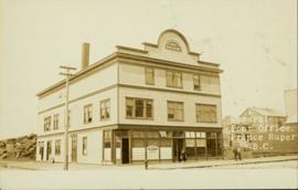
Street view of the Dominion Building in Prince Rupert, which contains the Government telegraph Office and Post Office. Printed annotation on recto reads: "Central Post Office Prince Rupert B.C." Handwritten annotation on verso reads: "Aug 18th. The cor. of the High bldg. on the right is the Prince Rupert Hotel. Front side is other way 5 stories high at [illegible] Hotel is in the next block. Notice [??] at the back is al-the [sic] lots of Hill leading down to Shops [??]. St. James' Hotel close by Prince Rupert was 5 stories high. For sure had [??] chimneys on it- a big fire engulfed [??] it about a year ago and it is being taken down. I must go & work bye bye. Love Dady. Psalm 46-1 & 48-14 was my AM verses specially."
File consists of correspondence and printed webpages on research at Central Queensland University.

Image depicts Central Street West, parallel to Highway 97 in Prince George, B.C. looking north. Shown: Prince George Motors and other car dealerships, Burger King, Grama's Inn, and the Spruceland Shopping Mall sign. Map coordinates 53°54'42.1"N 122°46'53.1"W
File consists of copies of correspondence from the National Research Council and clippings regarding the Centre for Advanced Research Techology at the College of New Caledonia. CNC received a federal grant to develop a computer-aid design and manufacturing system, which was intended to pioneer the use of computer technology in resource industries such as forestry and mining.
File contains correspondence to Brian Fawcett from Daniel Francis, Editor. Includes a letter regarding an article of Brian's to be published and illustrations. Letter dated June 26, 1985.
Scotland trip
File contains correspondence, a brochure and handwritten notes.
Series consists of one file of correspondence and handwritten notes concerning how the future Northern University might qualify as a Centre of Excellence.

Photograph depicts crowds of people walking through street, hills in background. Printed annotation on recto reads: “Centre St. Prince Rupert May Celebrations 1909, Allen Photo July 09.” Handwritten annotation in ink on recto reads: “Prince Rupert 1909”
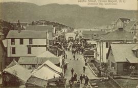
Photograph of Centre Street in Prince Rupert on Dominion Day. The Union Bank of Canada is located on the left side of the street, and a decorative arch can be seen in the background. Annotation on recto reads: "Centre Sr. Prince Rupert Dominion Day Celebrations 1909 Allen Photo July 09."
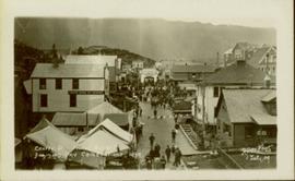
Elevated street view of a large crowd gathered on Centre Street in Prince Rupert for Dominion Day celebrations. The Dominion Day arch is visible in the background. Printed annotation on recto reads: "Centre Street, Prince Rupert, B.C. Dominion Day Celebration."

Photograph of residents in motion on Centre Street in Prince Rupert. Buildings are visible on either side of the street and a railway track runs down the length of the road. Annotation on recto reads: "Centre Street, Prince Rupert, BC. 1664."

Street view of Centre Street in Prince Rupert, BC. Buildings are in various states of construction. Printed annotation on recto reads: "Centre St Prince Rupert B.C. June 20/08 JDA.""
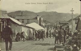
Street scene depicts people, boardwalks, tents, and store front. Printed annotation on recto reads: “Centre St. Prince Rupert: B.C., Allen Photos May 17. 09” Handwritten message on verso is addressed to “Dearest Darr”
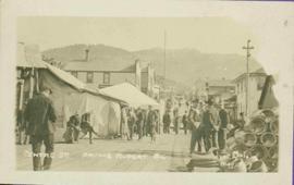
Street view of a crowd of men milling around on Centre Street in Prince Rupert, BC. Printed annotation on recto reads: "Centre Street, Prince Rupert, B.C."
File contents relate to: Engineering. Document type(s) include: blueprints.
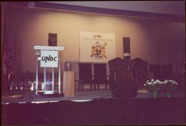
File consists of photographs of UNBC Ceremonial Chairs and Mace (UNBC Regalia).
Stamped annotation on verso reads: "MAY 1994".

Photograph depicts a ceremonial dancer in front of crowd wearing a colourful button blanket and headdress at the opening of the Haisla Recreation Centre in Kitamaat Village.

Photograph depicts a ceremonial dancer wearing a colourful button blanket and headdress at the opening of the Haisla Recreation Centre in Kitamaat Village.