Print preview Close

Showing 21755 results

Archival description
2020.4.2.1.13 · File · [ca. 1975]
Part of G. Gary Runka fonds

File consists of notes written by Joan Sawicki for an untitled pending speech by Gary Runka.

Commentary on this speech by Barry Smith of the Ministry of Agriculture and Lands:
"Despite this being only 4 pages of rough notes, its focus on the initial work of the Commission and challenges of designating the ALR make it an historically important document.

For example it was initially thought the ALR would be guided by class 1 - 4 CLI ratings but this proved impractical in the north and range areas. An additional challenge was that parts of the province only had the benefit of 1:50000 mapping. This presented a very real problem for establishing the ALR.

One concern with this document is that because it is written in point form and consists of rough notes, it could be open to a degree of misinterpretation if not considered by an individual with experience in the administration of the ALR. For a much more refined statement on the B.C. Agricultural Land Preservation program and the designation of the ALR see Items [2020.4.2.1.23, 2020.4.2.1.24, and 2020.4.2.1.25]."

"Notable Surveys"
2008.27.1.12 · Item · [1999?]
Part of Knox McCusker Collection

Item consists of a summary document entitled "Notable Surveys" by Mrs. W.K. Rutherford, V.C. Brink, R.S. Silver, and M.Z. ("Smokey") Neighbour. The document summarizes Knox McCusker's notable surveys. This article may have been put together by the authors for, or in conjunction with, a submission to a historical serial publication.

Northwood Pulpmill
2012.13.1.3.160 · Item · Nov. 2000
Part of J. Kent Sedgwick fonds

Image depicts the Northwood Pulpmill in Prince George, B.C. taken from above the Nechako River looking east. Map coordinates 53°56'00.0"N 122°44'29.7"W

Northern Rooms
2012.13.1.7.002 · Item · Oct. 1975
Part of J. Kent Sedgwick fonds

Image depicts an old building with a sign labelled "Northern Rooms" in an uncertain location somewhere in Prince George, B.C.

Northern British Columbia
2008.2.1.18 · Item · 1 May 1933
Part of Northern BC Cartographic Collection

Regional map depicting communities, parks, customs posts, airports, radio stations, hatcheries, bodies of water, transport routes, communication lines, elevation points, and lines of batholith contacts. Includes an inset of St. Elias Mountains. Includes “Special Note on the Mineralization of this Map Area” from Bureau of Mines, Victoria, B.C.

2001.1.085 · Item · 2016
Part of NBCA Document and Ephemera Collection

This document is an unpublished draft manuscript of a Northern British Columbia history annotated bibliography. The document is based overwhelmingly on research into secondary sources published prior to 2016; more recent sources are not included. The annotated bibliography includes the following sections:

  • Historiography
  • Settlement Histories
  • Alexander Begg's History of British Columbia
  • R.E. Gosnell
  • E.O.S. Scholefield
  • Regional History
  • New Histories
  • Environment
  • Northern History
  • Ancient History
  • Bibliography
2000.1.1.3.17.009 · Item · 1962
Part of Cassiar Asbestos Corporation Ltd. fonds

Photograph depicts tramline in a strip cleared of trees on McDame Mountain, bucket in foreground. Handwritten annotation on recto of photograph: "#2 SECTION LOOKING NORTH". Photograph was glued to cardboard backing with the annotation: "1962".

North Vancouver Ferry #3
2013.6.36.1.014.13 · Item · Apr. 1966
Part of David Davies Railway Collection
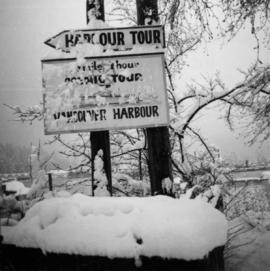
Photograph depicts the North Vancouver Ferry #3 at Western Boat Works at the extreme east end of the Westminster Highway on Lulu Island. It appears to be watertight.