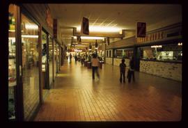
Image depicts the interior of a mall in Prince Rupert, B.C. It is possibly the Pride O' the North shopping mall.
Image depicts the interior of the Pride O' the North shopping mall in Prince Rupert, B.C.
Image depicts the Pride O' the North shopping mall in Prince Rupert, B.C.
Previous site of sawmill in Giscome, B.C. looking northwest. Map coordinates 54°04'19.7"N 122°22'04.7"W
Photograph depicts preserved KVR trackage near Faulder, west of Summerland.
Item is an original BC Parks report entitled "Preservation and Management of the Grizzly Bear in B.C. Provincial Parks: The Urgent Challenge".
Item is a photograph of Mr. Williston presenting Mr. Paget, retiring Deputy Minister of Water Resources, with a certificate for meritorious service.
Photograph taken at Brockton Oval, Stanley Park in Vancouver. Depiction of the Presentation of 2 Colours to the Vancouver City Police Force by Lieutenant-Governor of B.C. At this point, the colours had just been consecrated on an alter of drums. Drummers were regaining their drums.
Unidentified man stands on a log while spreading fish across beach with a poll in preparation for boiling. Handwritten annotation on verso reads: "Ooligans spread over the beach ready to go into the boiling tanks, near the Nass River, 1932."
Photograph depicts Prentiss Gray standing with a rifle in his hand in front of a teepee with a forested area in the background.
Photograph depicts Prentiss Gray standing with his rifle and horse in a grassy field. In the background a forested valley and snow-covered mountain range is visible.
Photograph depicts Prentiss Gray standing with his horse overlooking a backdrop of forest covered mountains.
Photograph depicts Prentiss Gray sitting on a log skinning his trophy mountain goat.
Photograph depicts Prentiss Gray sitting on a tree stump skinning his trophy mountain goat while Bruce Otto looks on.
Photograph depicts Prentiss Gray reaching out to a felled mountain goat lying on a rocky slope. In the background a mountain range is visible.
Photograph depicts Prentiss Gray standing beside a felled mountain goat on a rocky slope. In the background a mountain range is visible.
Photograph depicts Prentiss Gray climbing over fallen logs in an area of windfall.
Photograph depicts Prentiss Gray (left) and Mac McGarvey (right) seated in a boat on the Peace River.
Photograph depicts a man who is probably Prentiss Gray standing over three felled grizzly bears. The man is holding onto the reins of a horse and a rifle while a mountain range rises up in the background.
Photograph depicts a man, probably Prentiss Gray, standing over three felled grizzly bears while holding the reins of his horse and a rifle. In the background a mountain side rises up in the distance.
Photograph depicts a man who is probably Prentiss Gray standing over three felled grizzly bears. The man is holding the reins of a horse while a mountain rises in the distance.
Photograph depicts Premier Peter Lougheed talking with unidentified men at the Crest Hotel in Prince Rupert during Campagnolo's Skeena Riding tour. Campagnolo stands behind Lougheed. Several unidentified people talk behind them.
Photograph depicts Premier Peter Lougheed and an unidentified man sitting at a table and talking at the Crest Hotel in Prince Rupert during Campagnolo's Skeena Riding tour. An unidentified group of people sit a table behind them.
Handwritten annotation on recto: "Hon. Brewster (Premier), Hon. T.D. Pattullo and party on Peace River"
Annotation on photograph verso: "View from Jtn of A Road and Main Road to NE. Pre-logging. 15/1/92. Summit Lake Selection Trial"
Item is a preliminary plan showing traveled route of the Bedaux Sub-Arctic Expedition in 1934.
Colour-coded map depicting lands surveyed as alienated, reserved, and having a timber license, lease, or sale. Depicts land recording divisions, land district boundaries, communities, bodies of water, and transport routes. Includes insets of Stephens Island and Egeria Reach.
Map depicting surveyed lands, statutory timber lands, land recording divisions, game reserves, communities, bodies of water, and transport routes. Includes inset of McBride townsite.
Colour-coded map depicting surveyed lands respectively open and closed to preemption. Depicts land recording divisions, game reserves, communities, bodies of water, and transport routes. Includes inset of McBride townsite.
Colour-coded map depicting lands open for preemption, in “University Reserve,” or reserved for public auction. Depicts land recording divisions, communities, bodies of water, and transport routes.
Colour-coded topographic map depicting lands surveyed as alienated, reserved, or statutory timber land. Depicts land district boundaries, land recording divisions, HBC posts, triangulation stations, telephone lines, communities, bodies of water, and transport routes. Defines resource type areas (“Land Form,” “Soil,” “Forest Cover,” “Grazing,” “Geological & Mineralogical,” “Fur-Bearing Animals & Game”). Includes explanatory “Natural Resources Reference.”
Colour-coded map depicting surveyed lands respectively open and closed to preemption. Depicts land recording divisions, land district boundaries, government reserves, communities, bodies of water, and transport routes. Includes topographical inset.