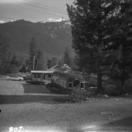
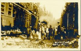
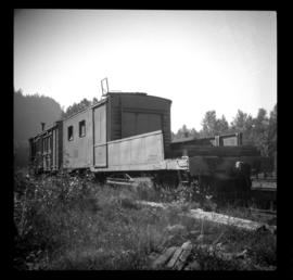
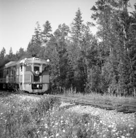
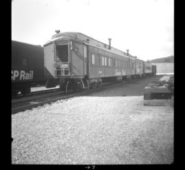
Photograph depicts a 12 wheeler passenger car, CPR #411641, used as car man's sleeper. Behind it is wash/shower car #412718. It is followed by work diner car #411369, which is also a 12 wheeler with an arch bar truck. They are used for work and wreck train service.
Photograph depicts an old passenger car converted to a cafe at Pemberton and Anderson Lake. It is either at Mount Currie or D'Arcy.
Photograph of man on the back of a passenger car attached to a steam engine. Printed annotation on recto is obscured by emulsion damage and reads: "[illegible] Atlin, B.C."
Photograph depicts the Nanaimo passenger depot of the Esquimalt and Nanaimo Railway (at right) and the E & N freight shed (at left).
Photograph depicts the "MV Ballena" docked at a wharf. The Ballena was a passenger ferry built in 1892 by the Albion Iron Works Company of Victoria and originally named the Joan. This ship was sold to the Terminal Steam Navigation Company in 1914 and renamed the Ballena. It was later acquired by the Union Steamship Company in 1920 but burned at the Union dock in November of that year.
Photograph depicts a few passenger trains and a band wearing traditional garb.
Photograph depicts a passing spur on the B.C. Electric Railway at Kennedy Station, 4 miles south of New Westminster. The view is looking north.
Photograph depicts the rail connections below the north bank of the Patullo Bridge in New Westminster. The track in the foreground belongs to C.N. and the flyover foreground rail bridge belongs to the B.C. Electric Railway. The flyover background rail bridge is shared by the Great Northern Rail and C.N. Rail.
Photograph depicts the Patullo Bridge in New Westminster, looking east with the rail bridge in the background.
Photograph taken at the Paulson Highway Bridge.
Photograph taken at the Paulson Highway Bridge. Site of a snow shed until the early 1980's when it was demolished and a slide fence was installed.
Photograph taken at the Paulson Highway Bridge.
Photograph taken at the Paulson Highway Bridge. KVR track visible on a former Boundary Subdivision between Castlgar and Grand Forks.
Image depicts the road to Pavilion Mountain.
Side perspective photograph of a crowd of people gathered around a Portland Canal Short Line Railroad train, presumably either leaving or arriving Printed annotation on recto reads: "Bitter Creek BC Aug 9 1911."
Side perspective photograph of a Portland Canal Short Line engine being either loaded or unloaded by several men at the station in Stewart, BC. Printed annotation on recto reads: "Aug 9 1911 Stewart BC."
Image depicts the Peace Canyon Dam and generating station under construction on the Peace River.
Image depicts what is possibly the Peace River running parallel to a road, possibly Highway 29.
Image depicts a dam, possibly on the Peace River.
Image depicts a dam on what is possibly the Peace River.
Image depicts the W.A.C. Bennett Dam on the Peace River in Hudson's Hope, B.C.
Photograph depicts a pedestrian overpass, with rail below, leading to the Riverside Park and Coliseum. CPR container freight was moving westwards.
Image depicts the CN Station in Penny B.C.
Image depicts the CN Station in Penny B.C. A woman, possibly Sue Sedgwick, is sitting against the outside wall.
Photograph depicts the Penticton CPR depot. The view is looking northwest.
Photograph depicts four people looking at the ocean from car deck of "Kwuna" ferry at Sandspit, Queen Charlotte Islands.
Image depicts two trains in Prince George, B.C.
Photograph depicts a northbound 4 unit Budd passenger train at the flag stop in Australian, BC.
Photograph depicts a Pacific Great Eastern trestle.
Photograph depicts a trestle near Australian, BC on mile 364. Visible is a northbound freight of 2 locomotives and about 60 cars.
Photograph depicts a Pacific Great Eastern ballast car which was built in 1955 by Eastern Car Company in Trenton, Nova Scotia.
Photograph depicts a section house, track motor shed, and a disused bunk house and supplies shed which are property of the Pacific Great Eastern Railway.
Photograph depicts a steel works car with an open end for ties and other material.
Photograph depicts a PGE crossing over the Fraser River.
Photograph depicts a PGE crossing over the Fraser River, north of Lillooet. Visible on the far bank was an old grade that led to a former bridge about a mile downstream.
Photograph depicts an early model Jordan Spreader used in the construction of the Pacific Great Eastern Railway. A railway worker is standing on the spreader. The stencil on equipment states "P.G.W.R.R.". The flora suggests that this photograph may have been taken somewhere in the Lillooet/Clinton area.
Photograph depicts an inspection speeder passing Jordans which was near the Whistler Mountain ski lift.
Photo displays the Pacific Great Eatern Railway depot in Kelly Lake on mile 192.7.
Photograph depicts the remains of Pacific Great Eastern trackage beside a primitive small grain elevator laeding off at the end of the "Y" at Kelly Lake. It was probably not in use for the past 20 or 30 years, as of 1972.
Photograph depicts gondola cars sitting on a turning Y, unloaded, and covered with plastic. They were awaiting switching to an ore mine loading loop about 5 miles up the line.
Photograph depicts a southbound Budd car train about to deport.
Photograph depicts an auxillary car with a powered winch found at the Pacific Great Eastern yards in Lillooet. Inside the roundhouse in the background was a boiler room that contained a locomotive boiler in working order.
Photograph depicts the PGE line at an unknown location.
Photograph taken on mile 178.0. Depicts a work train on a spur with a water tank car.
Photograph taken loooking southwards, down the Fraser Canyon, between Pavilion and Lillooet. Visible is a northbound Budd car going slowly up a steep grade.
Photograph depicts a work train on a spur. Taken from the shelter of the depot in Pavilion.
Photograph depicts a disused snow plow #6001 that was built of wood. Snow plough #6002 is found behind.
Photograph location is unknown, but Davies stated it to be possibly somewhere north of Quesnel. A bridge is visible.