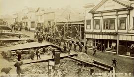
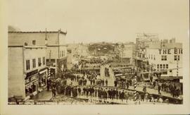
Photograph of a small marching band parading down Second Avenue in Prince Rupert. A large crowd is gathered. Annotation on recto reads: "Photo by MacRae Bros Prince Rupert BC 2nd Ave Prince Rupert BC."
Photograph of a marching band performing down a wooden road. Spectators can be seen in the foreground and various businesses are in the background. Annotation on recto reads: "Prince Rupert BC."
Image depicts a marching band with numerous other unidentified individuals. One man is carrying a Canadian flag with the depiction of men in a boat and the words "Canada Sea-to-Sea" on it, and there is a mascot beside him that appears to be a chipmunk in an RCMP uniform.
Image depicts a marching band with numerous other unidentified individuals. One man is carrying a Canadian flag with the depiction of men in a boat and the words "Canada Sea-to-Sea" on it.
Map depicts the rivers, railways, and select lakes and towns located at Jasper Park between the northern boundary of the park and the townsite of Jasper. Part of the border between Alberta and British Columbia is visible on the west of the map.
Map reflects reserve boundary, roads, trails, 20 feet contour intervals, air photo centre, declination, swamps, and mile post at the Aleza Lake Forest Reserve.
Photograph depicts a map of the Prince George-Peace River district after the 1961 census.
Photograph depicts a map of the Prince George-Bulkley Valley district after the 1971 census.
Photograph depicts colour map displayed in unknown area, second poster semi-visible on left. See item 2008.3.1.22.34 for image believed to depict lava bed.
Image depicts a man holding up a board which appears to have maps of the Cottonwood Park on it.
Item is a photocopied map of the Aleza Lake area annotated to show transects.
Item is a reproduced map of Aleza Lake annotated to show a 1994 RFP study area.
Photograph of the Prince Rupert wharf. Many vessels are docked next to small buildings along the water. Annotation on recto reads: "Prince Rupert BC."
Image depicts the road to Manson Creek, B.C.
Image depicts the Omineca Museum in Manson Creek, B.C.
Image depicts a creek with a half collapsed shack in the background somewhere in Manson Creek. The slide is labelled "Manson workings."
Image depicts the gas station at Manson Creek, B.C.
Image depicts a man and his family filling up their truck with gas at Manson Creek, B.C.
Image depicts Manson Creek, B.C.
Photograph depicts two men in plant site, mountains in background. Corresponding note on accompanying photo description page: "Pictures taken July 3rd, 1952. 3. Quonset warehouse in background. Temporary set-up for circular saw in foreground."
Photograph depicts four unknown animals in distance on mountain slope, valley in background.
Photograph depicts a mill with scaffolding on the left side of the building. A second scaffolding structure is in the foreground with trees and mountains in background. Typed annotation taped to verso of page stapled to photographs: "View of mill building looking west."
Photograph depicts body of water in mountain valley, trees surrounding.
Photograph depicts water tower. Piles of building material in foreground, trees and mountains in background. Corresponding note on accompanying photo description page: "Pictures taken July 17th, 1952: 12. Water tower nearly completed. Piping job underway. Looking northwest."
Photograph depicts tower, small building in base. Vehicle on left, trees and mountains in background. Corresponding note on accompanying photo description page: "July 26th: (6) Water tank & tower."
Photograph depicts pipes laid in ground on wood structure, power house and men on scaffold in background. Building materials on left in foreground. Corresponding note on accompanying photo description page: "August 20th: 7. Installing water pipes from water tank to Power House. Oil tanks on left. Looking southeast."
Photograph depicts dirt in washout on mountainside. Corresponding note on accompanying photo description page: "5. Wash-out past 3rd switchback."
Photograph depicts washed-out areas on mountainside. Corresponding note on accompanying photo description page: "3. Wash-out above road just past 1st switchback. There was no indication of any water running here before."
Photograph depicts dirt area. Shrubs, snow-covered area, and mountains in background. Corresponding note on accompanying photo description page: "6. Wash-out and rock slide in second gully containing snow."
Handwritten annotation in blue ink on recto of photograph: "Warehouse in construction." Photograph depicts two men working in warehouse interior, and one man sitting on top of wall with sledge hammer raised. Miscellaneous building tools and supplies throughout.
Handwritten annotation in blue ink on recto of photograph: "Foreground warehouse under construction and in the background lays asbestos." Photograph depicts two men walking towards warehouse building. Walls are erected though roof is not. Steel drums and equipment under tarp shelter in foreground, trees and mountaintops in background.
Photograph depicts crushed vehicle in wooded area, mountains in background.
Photograph depicts valley and mountain range, speculated to be the Cassiar valley.
Photograph depicts equipment believed to be in the concentrator, dryer, or mill building. Typed annotation taped to verso of page stapled to photograph: "Close-up of vacuum hood which sucks fibre away from the rock."
Photograph depicts unknown structure propped against side of dirt hill and believed to be in plant site. Structure speculated to be a chute or conveyor belt. Trees and mountains in background.
Photograph depicts four large trucks hauling miscellaneous material on road. Mountain in background, believed to be Cassiar area.
Photograph depicts ore truck being loaded at chute, road in foreground, man on right. Corresponding note on accompanying photo description page: "August 5th: 8. Loading truck from chute on top of mountain."
Photograph depicts concrete walls in ground, building materials on right. Corresponding note on accompanying photo description page: "August 25th: 10. Concrete walls for truck dump and coal handling bin. Power house in background. Looking north from mill roof."
Photograph depicts men building truck dump in foreground, building believed to be power house in background. Corresponding note on accompanying photo description page: "Pictures taken June 11th: (3) Framing water tank tower. Water well in foreground and tower timbers and oil tanks in background. Looking east." [Note believed to be incorrect.]
Photograph depicts men building framework for truck dump. Truck and mountains in background. Power house framework believed to be in background.
Photograph depicts crushed vehicle in wooded area.
Photograph was taken facing down a narrow, snowy trench, mountain base visible at end. Corresponding note on accompanying photo description page: "1. Trench through snow banks at mill site. We had to dig these trenches to facilitate surveying the mill foundations."
Photograph depicts track loader moving dirt in semi-cleared area. Trees and mountains in background.
Photograph depicts track loader moving dirt in cleared area. It is believed that the loader may have been excavating area for ore haul truck dump (see item 2000.1.1.2.222). Trees and mountains in background.
Photograph depicts man on dirt road, many small buildings on left. Mountains in background. Corresponding note on accompanying photo description page: "12. Temporary Campsite."