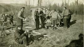
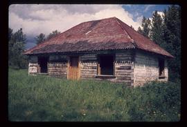
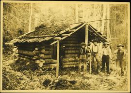
Photograph depicts four men standing in front of small log cabin with sod roof. It is believed that these men are also featured at Ah Yee's in item 2009.5.3.16. A man believed to be Meikle sits in window of cabin. Forest in background. Handwritten annotation on recto of this photograph reads: "Meikle's Cabin mouth of Clearwater".
Photograph depicts Iona Campagnolo, Vic Walton, and John Blake sitting at a table during a meeting with disaster officials in Terrace.
Photograph depicts Iona Campagnolo, Vic Walton, and John Blake sitting at a table and speaking to disaster officials at a meeting in Terrace.
Photograph depicts Brian and Lisa, two students from Booth Memorial High School in Saint John’s Newfoundland, sitting during a meeting in Iona Campagnolo’s Ottawa office.
Photograph depicts a mechanical side cutting machine at the C.P.R. Coquitlam yards.
Photograph taken in Coalmont, a ghost village that was livening up. Visible is the Meat Market store, the only surviving building on the frintage of this block, adjacent to the hotel.
Item is a photograph of a copy print, resulting in a low quality photographic reproduction. Reproduced as a print, slide, and a negative. Location of original photograph is unknown.
Photograph depicts a meat hanging shed on a ranch on Granby River Road, Grand Forks.
Photograph depicts a meat carcass windlass.
Caption: Taking water contents of the snow on the hills for Ocean Falls water supply. Item is a photograph of four men taking a water content measurement on a snowy slope.
Annotation on recto: "I-33253" which denotes the same photograph in the collection of the BC Archives.
Handwritten annotation on recto: "Meal time near Brennan's Flats where gold dredging on Peace River, Sept. 1921". Photo depicts three men standing next to a campfire.
Photograph depicts (from left to right) Bill McPhee, an unidentified man, a dog, and Frank 'Shorty' Weber standing in tall meadow grass in front of a sparsely forested landscape in front of a mountain range. The location of the photograph is noted to be at Duck Creek below Copper Mountain; however, those names may no longer be in current use. Location is assumed to be approximately 55.979291, -125.208415 near what is currently named Wasi Peak.
Frank ‘Shorty’ Weber had a trapline on the upper Ingenika for over 30 years. and he was well-known in the Finlay River area.
Item is a landscape photograph taken across Kitchener Lake.
Item is a photograph of a pack horse train traversing across a meadow.
Photograph depicts McRae Creek Falls.
Photograph depicts McRae creek canyon.
Photograph depicts McRae Creek Falls.
Image depicts part of the McMillan Creek Trail in the McMillan Regional Park in Prince George, B.C.
Image depicts part of the McMillan Regional Park in Prince George, B.C.
Image depicts the McMillan Creek from Northwood Pulpmill Road, in Prince George, B.C.
Image depicts the McLeod River in Carp Lake Provincial Park.
Image depicts a shack with a red roof near McLeod Lake.
Image depicts the old Hudson's Bay Company Trading Post at McLeod Lake.
Image depicts a building by the shore of McLeod Lake.
Image depicts McLeod Lake, with the view facing north-west.
Image depicts McLeod Lake.
Image depicts McLeod Lake and several buildings along the shore.
Image depicts McLeod lake.
Photograph depicts a tiny switcher that belonged to the McLean sawmill and was buily by Buda of New Westminster, circa 1927. Sat on unconnected trackage adjacent to the Alberni Pacific Railway and was part of a sawmill exhibit.
Photograph depicts dry creek bed, tall banks on either side. Hills and lake cross midground, mountains visible in background. Handwritten annotation on verso of photograph: "Looking down McKee Creek across Atlin Lake Towards Taku Glacier 6/27/37."
Image depicts a dirt road and a densely forested treeline, possibly in the McGregor Valley.
Image depicts a pass in the McGregor Valley.
Image depicts a view of a section of a pass in the McGregor Valley.
Image depicts a what is possibly the McGregor River in the McGregor Valley.
Image depicts a gravel road somewhere in the McGregor Valley.
Image depicts numerous felled trees somewhere in the McGregor Valley.
Image depicts a red vehicle parked on the side of the road with a view of the McGregor Valley behind it. The slide is labelled "dam site."
Image depicts numerous burned tree stumps somewhere in the McGregor Valley.
Image depicts a view of McGregor Valley from an uncertain location.
Image depicts a view of McGregor Valley.
Image depicts a view of the McGregor Valley.
Image depicts a view of McGregor Valley.
Image depicts a view of McGregor Valley from an uncertain location.