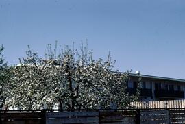
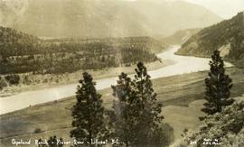
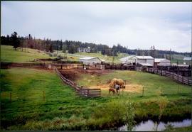
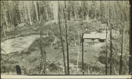
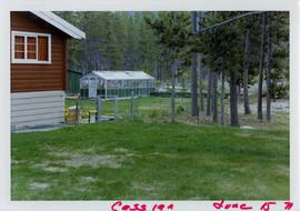
Photograph depicts part of a brown and white building similar to the "Director's Lodge" at Cassiar, B.C. (see items 2000.1.1.3.19.88 and 2000.1.1.3.19.89). Unidentified individuals visible inside greenhouse in fenced back yard. Forest in background. Handwritten annotation on verso of photograph: "Cassiar June 15 71".
Image depicts a cow at an uncertain location.
Photograph depicts a cow with a bell around its neck standing in the front yard of a house.
Item is a photograph of forests and farms from the air.
Image depicts an agricultural field, most likely near Prince George, B.C.
Subseries consists of material collected and created by Kent Sedgwick for research relating to agriculture in Prince George and the surrounding areas including Pineview, Mud River, and Blackburn. Includes material regarding the Prince George experimental farm, historical agriculture, dairying, and ranching.
Image depicts some farmland near Alexandria, B.C.
Slide depicts an apple tree blossoming in a backyard. The yard is surrounded by a wooden fence. Original slide index description: "Apple blossoms Kelowna."
Item is a photograph of a river bend and the surrounding country taken from the air.
Item is a photograph of a rural area taken from the air.
Item is a photograph of boats docked on the shore behind piles of grain or straw.
Item is a photograph of rows of plants in a garden.
Item is a photograph of people harvesting grain by hand.
Item is a photograph of sheaves of grain against a brick wall.
Item is a photograph of a woman working in a field.
Series consists of records created and collected by Gary Runka during and after his time with the British Columbia Agricultural Land Commission. In the early 1970s, Runka served as the first general manager of the BC Agricultural Land Commission, the independent provincial body that has administered BC's Agricultural Land Reserve (ALR) for over 40 years. As the first manager, Runka spearheaded the establishment of the ALR undertaking the technical tasks of setting ALR agricultural use boundaries, policies and procedures, as well as the building awareness and support for farmland preservation within government and with the public. He later served as Commission chair. Records include correspondence, informational material, publications, clippings, news releases, memoranda, symposium/conference material, reports, speech notes, and other textual material. Also includes seven maps, two buttons, six floppies, eighty slides, and one audio cassette tape.
Image depicts a field of hay somewhere in Beaver Valley.
Photograph features a wooden box of pears sitting on grass, bushes in background. Handwritten annotation on recto of photograph: "This is a prize box of pears." It is believed that this photograph was given to Lillian & A.K. Bourchier by their niece Jean.
Typed caption glued to album page directly below photograph reads: "37. Wonderful growth of Cauliflower near Fort Fraser." Photograph depicts an elderly man holding two large cauliflower heads, a small boy stands next to him. Photographer: Dominion Stock & Bond Corporation.
Slide depicts cherry trees blossoming in an orchard. Original slide index description: "Cherry blossoms Lakeview Heights."
Image depicts a view of some farm land in Chetwynd, B.C.
Series consists of the client file project records of G.G. Runka Land Sense Ltd., Gary Runka's consultancy business (co-owned with Joan Sawicki until 1991). G.G. Runka Land Sense Limited was incorporated as a company on 30 Nov. 1978 and dissolved on 30 Nov. 2018. Most business activity ceased after Gary Runka's death in July 2013. The company provided comprehensive professional services in land inventory, environmental assessment, integrated resource management, land and water use conflict resolution and interdisciplinary land use planning. Over the course of the company's operation, Gary Runka and his firm consulted on 681 assignments ranging from very large projects (such as the Site C project) to small residential/commercial land capability assessments.
The Land Sense Ltd. client files generally include records such as correspondence, contracts, invoices, project reports, publications, ephemera, memoranda, map excerpts, legal documents, meeting materials, clippings, and handwritten notes. Some client files are accompanied by related maps, photographs, aerial photographs, and/or digital records on storage media.
Photograph depicts the Copeland ranch on a bench of the Fraser River in Lillooet, BC.
Image depicts two unidentified individuals and a van on a farm at an uncertain location, possibly a place called Cypress Hill, with an atmometer and a sunshine recorder.
Image depicts a farmhouse in Dome Creek, B.C.
Image depicts a horse and a barn in Dome Creek, B.C.
Image depicts a small farm located in Dome Creek, B.C.
Image depicts a view of an experimental farm, possibly taken from Tabor Mountain.
Image depicts a farm likely in Woodpecker, B.C.
Image depicts a farm at an uncertain location.
Image depicts what appears to be a farm at an uncertain location.
Image depicts a farm likely in Woodpecker, B.C.
Image depicts a farm at an uncertain location.
Image depicts a farm at an uncertain location; possibly somewhere in the McGregor Valley.
Image depicts a farm at an unknown location.
Photograph depicts two horses in one of many fenced areas, buildings and machinery in background. Highway, house, and forest also visible in distance.
Photograph depicts snowy area speculated to be a farm yard in foreground. Frozen water crosses midground, opposite shore in distance.
Image depicts a street, possibly in Kamloops, which has been closed for a Sunday morning Farmer's Market.
Photograph depicts farmstead in cleared area of forest. Plowed and fenced area on left, buildings and firewood on right.
Typed caption glued to album page directly below photograph reads: "81. Field of Oats and Potatoes near Fort Fraser." Photographer: Dominion Stock & Bond Corporation.
Barbed wire fence in foreground, shed in background.
Turkeys in foreground, shed in background.
Firewood pile in left foreground. Buggy, wood house, and porch in background. Handwritten annotation on recto of photograph: "Wishing Aunt Lillian + Uncle Alan a very Merry Xmas and Happy New Year. Please do not criticize the stitches too closely Aunt Lillian. These snaps are some of part of my flock of 102 this year. These were snapped about a week before Thanksgiving. All the birds you see are this year's hatch. Some of them dressed 17 1/2 + 18 lbs at Thanksgiving. With love from Jean."
Image depicts a group of unidentified individuals in a greenhouse, possibly somewhere in Fort St. John, B.C.
Image depicts an unidentified man in a greenhouse, possibly somewhere in Fort St. John, B.C.
Photograph depicts young fruit trees planted in fenced area with small wind mill, hills in background. Handwritten annotation on recto of photograph: "This is part of the fruit trees if you place it along side of the other one you can see the location the farm buildings are on the other side I didn't get one of them."
This fonds illustrates the life and work of G. Gary Runka and his contributions to the province of British Columbia. Gary Runka was the first General Manager of British Columbia's Agricultural Land Commission and helped establish the provincial Agricultural Land Reserve. After transitioning from a government career to private consulting, Runka provided comprehensive professional services through his land consultancy business, G.G. Runka Land Sense Ltd., offering land capability and environmental assessments, integrated resource management, land and water use conflict resolution, and interdisciplinary land use planning. Described by colleagues as one of BC's most highly respected agrologists and influential land use planners, Runka had a 52-year career working on (or against) an incredible number of landmark projects in British Columbia, such as the Site C Project. Gary Runka’s partner in life and vocation, Joan M. Sawicki, worked with Gary on many of these projects—as well as her own; her contributions are also represented throughout the records of this fonds.
Gary Runka's deep connection to the land is evident from his earliest papers on aerial photo interpretation, his work with the Canada Land Inventory, through his speeches and his work establishing the BC Agricultural Land Reserve and in his subsequent consulting career through G.G. Runka Land Sense Ltd. Gary Runka's influence and legacy was recognized in the tributes paid after his death, including the post-humus award as the Real Estate Foundation's "Land Champion" for 2014.
The G. Gary Runka fonds has been divided into the following nine series:
1) Personal Records
2) Speeches & Publications
3) Professional Records
4) Agricultural Land Commission
5) Land Sense Ltd.
6) Client Files
7) Maps
8) Photographs
9) Digital Records
Subseries consists of publications, manuscripts, and drafts of worked written, co-written, or edited by G. Gary Runka over the course of his career. Also includes conference proceedings that contain contributions by G. Gary Runka.