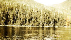
Photograph depicts looking toward a treed shoreline from the water. Klemtu was also known as China Hat due to the shape of Cone Island, which protects it from the open water. Handwritten annotation below photograph reads, "Bay at China Hat, BC Coast".
Series consists of records created and collected by Gary Runka during and after his time with the British Columbia Agricultural Land Commission. In the early 1970s, Runka served as the first general manager of the BC Agricultural Land Commission, the independent provincial body that has administered BC's Agricultural Land Reserve (ALR) for over 40 years. As the first manager, Runka spearheaded the establishment of the ALR undertaking the technical tasks of setting ALR agricultural use boundaries, policies and procedures, as well as the building awareness and support for farmland preservation within government and with the public. He later served as Commission chair. Records include correspondence, informational material, publications, clippings, news releases, memoranda, symposium/conference material, reports, speech notes, and other textual material. Also includes seven maps, two buttons, six floppies, eighty slides, and one audio cassette tape.
Photograph is a group portrait of BC Agricultural Land Commission staff members at a Christmas party. Back row, left to right: Patti, Terry Lewis, unknown, Julie Glover, Gordon Gram, Gary Holisko, Kirk Miller, unknown, Shirley Brightman. Middle row, left to right: Eve Lew, Jim Plotnikoff (Santa). Front row, left to right: Verona Hoosen, unknown, Jane Perch, Denise Jankovich, unknown, unknown.
Subseries contains material collected and created by Kent Sedgwick for research on various areas in British Columbia and Alberta. Includes written notes by Kent Sedgwick, pamphlets, and newspaper clippings relating to towns and settlements. These areas include Quesnel, Likely, the Yukon Telegraph Trail, Barkerville, Wells, the Cariboo region, Fort Alexandria, Soda Creek, the Chilcotin region, Jasper, the Rocky Mountains, Mackenzie, Tumbler Ridge, the Peace River region, Fort St. James, the Omineca region, Kitimat, Lethbridge, the Bulkley Valley, and Fort Mcleod. These files cover a variety of topics including Chinese people in British Columbia, land settlement, tourism, and historic information on the regions.
File contains slides depicting maps from the B.C. Atlas.
Photograph is a group portrait of the British Columbia Canada Land Inventory team. Back row, left to right: Rob Hawes, unknown, Ivan Cotic, Terje Vold, John Wilcox [?], Keith Valentine, unknown, Alec Green [?], Horst Baender, Dick Marshall, unknown, John Senyk, Bill Watt, Neville Gough, Dan Blower, unknown, Gavin Young, Craig Brownlee. Middle row, left to right: unknown, Peter Murtha, unknown, unknown, John Harris, Al Aldred, Gary Runka, Ed Oswald, Mary Redmond. Front row, left to right: Rick Williams, Gerry Howell-Jones, Chris Stanley-Jones, Larry Lacelle, John Jungen, Tom Pierce, Jim Van Barneveld.
Photograph depicts the Department of Highways ferry named "Nimpkish" that was based in Port McNeill. It maintained a frequent daily triangle run, that travelled from Port McNiell to Sointula, then to Alert Bay. It held a capacity for 16 cars and 150 passengers.
Photograph depicts B.C. Electric ballast car #3013 standing on the new industrial siding on the northeast side of the Langley depot.
Item is a photograph of the B.C. Electric Board taken the day after the company’s take over by the Social Credit government on August 1, 1961. Pictured from the left are: Bill Means, former Lieutenant-Governor Frank Ross, Einar Gunderson, board secretary W. Goth, Gordon Shrum, Mr. Williston, Hydro lawyer Arthur Fouks and John Dunsmuir.
Photograph depicts the B.C. Electric rail bridge crossing the north section of the north arm of the Fraser River from Vancouver to Mitchell Island. The span is always kept open except for rail traffic.
Photograph depicts the B.C Electric rail bridge crossing the south section of the north arm of the Fraser River. The view is looking north from Mitchell Island, which takes steel traffic to and from the Western Canada Steel Ltd.
File consists of documentary photographs taken by David Davies of the B.C.E.R. in British Columbia.
File consists of documentary photographs taken by David Davies of the BC Electric Railway on Granvile Island, Vancouver.
Photograph depicts a view looking northeast of the B.C. Electric Railway from the abandoned Sumas substation at Vedder Mountain.
Photograph depicts the B.C. Electric Railway, looking east from the depot at Cloverdale.
Photograph depicts the B.C. Electric Railway crossing 3rd Ave. with the first intersection at the immediate left. Note the abandoned double trackage at left. The view is looking north.
Photograph depicts the B.C. Electric Railway crossing at Serpentine Creek, 2 miles west of Cloverdale. The view is looking north.
Photograph depicts the B.C. Electric Railway crossing on Main St. in Langley, looking southwest.
Photograph depicts the B.C. Electric Railway depot at Huntingdon and Sumas, about 20 ft from the U.S.-Canadian border. The view is looking southeast.
Photograph depicts the B.C. Electric Railway in Langley, looking northeast from town grade crossing.
Photograph depicts a B.C. Electric Railway locomotive #902 and boxcar entering the Kitsilano yards and crossing 2nd Ave., near Fir St. in Vancouver.
Photograph depicts a B.C. Electric Railway locomotive #902 crossing the False Creek trestle, travelling north.
Photograph depicts the B.C. Electric Railway turning east at Glover Rd., south of Fort Langley.
Photograph depicts the B.C. Electric Railway swing bridge at False Creek on the west side looking north.
Photograph depicts the fixed span of the B.C. Electric Railway swing bridge at False Creek looking south.
Photograph depicts the B.C. Electric Railway swing bridge at False Creek.
Photograph depicts the B.C. Electric Railway trestle bridge swinging span at False Creek.
Photograph depicts the B.C. Electric Railway swing bridge at False Creek on the west side looking east as it is about to swing open.
Photograph depicts the B.C. Electric Railway trestle bridge over False Creek looking north at the fixed span. The fixed span can be removed by floating it onto a scow on rising tide to allow large and newly launched ships to get out to sea.
Photograph depicts the under face of the B.C. Electric Railway swing bridge at False Creek looking north.
Photograph depicts the False Creek Trestle bridge open and the Granville Bridge looking east.
Photograph depicts the B.C. Electric Railway swing bridge connecting Lulu Island to the mainland at New Westminster, looking north and taken from Lulu Island. The swinging span is left open except for the passage of freight trains.
Photograph depicts B.C. Electric Railway trackage being removed to approaches of locomotive house in New Westminster. The view is looking northeast, probably up 14th St.
Photograph depicts the B.C. Electric Railway trackage at Kerrisdale in Vancouver. The photo was taken from 49th Ave. and West Boulevard, looking north. The second track used to lie to the right of the existing one.
Photograph depicts a B.C. Electric Railway trolley electric locomotive #960, in freight yard below the Georgia Viaduct in Vancouver.
Photograph depicts the B.C. Electric Railway workshops at the south end of the Burrard bridge in Vancouver. The view is looking west and depicts caboose A10 in the background.
Postcard photograph depicts lofty view of sternwheeler in river, snow capped mountains in background.
Printed annotation on recto reads: “R.M.S. B.C. Express in Upper Canyon Fraser River.”
2 Stern wheelers tied to the river bank. Printed annotation on recto reads: “The B.C. Express mail Steamers No. 102.”
Photograph depicts a paddle wheel conveyor believed to be in distress in the Fort George Canyon on the Fraser River. Rocky bank in foreground, trees on opposite shore in background.
Photograph depicts a paddle wheel conveyor believed to be in distress in the Fort George Canyon on the Fraser River. Trees on opposite shore in background.
Photograph depicts a paddle wheel conveyor believed to be in the Fort George Canyon on the Fraser River. Rocky shore in foreground, trees on opposite shore in background.
Photograph depicts sternwheeler passing through rapids of the Fraser River, B.C. Printed annotation on recto reads: “The B.C. Express Passing through the Grand Canyon B.C.”, handwritten in red ink: “1913”.
Postcard photograph depicts sternwheeler, men visible on deck, hills on opposite shore in background.
Printed annotation on recto reads: “B.C. Express Steamer, Fraser River.” Handwritten annotation in pencil on verso reads: “BC Express Fraser River BC”.
B.C. Express Steamer, Fraser River. Trees and mountains in background. Printed annotation on recto reads: “B.C. Express Steamer, Fraser River.” Handwritten annotation in pencil on verso reads: “BC Express Fraser River BC”
Photograph depicts the "Queen of Victoria," in the Burrard Dry Dock. It was being lengthed by an addition of a new midships section.
Photograph depicts the B.C. Ferry Authority ship the "Comox Queen" at the Little River wharf on Vancouver Island. It is 4 miles north of the village of Comox.
Photograph depicts a B.C. Ferries vessel on standby as a relief slip during winter shedules.
Photograph depicts the B.C. Ferry Authority Vessel M.V. "Jervis Queen" undergoing a refit at Deas Island basin in the Fraser River.